Wisconsin to see near-record-high temperatures as weather turns extra hot
It's set to be a scorcher Monday and Tuesday across Wisconsin, with heat indices exceeding 100 degrees in some areas, according to the National Weather Service.
A heat advisory is in effect for Monday for much of northern Wisconsin until 8 p.m., where heat indices — the combination of temperature and humidity — will reach 100.
The advisory covers the area from Waupaca north to Iron Mountain, Michigan, and west to the Minnesota border.
The weather service has also issued a heat advisory for noon to 7 p.m. Tuesday. It covers the rest of the state: from Green Bay south to Kenosha and west to the Iowa border.
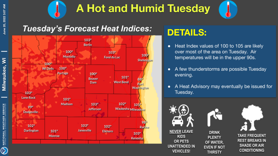
Southeast, south-central Wisconsin
Southeast and south-central Wisconsin on Monday are expected to see heat indices in the low to mid 90s.
But on Tuesday, the regions will likely see heat indices of 100 to 105 degrees, according to the weather service.Air temperatures will be in the upper 90s.
Highs for Monday and Tuesday are expected to be about 15 degrees above normal for this time of year, according to the weather service. The average high in June in Milwaukee is 77 degrees.
It's likely that the heat Monday and Tuesday will near historic highs for the date.
The record-high temperature for June 20 in Milwaukee is 99 degrees, set in 1953. The record for June 21 is 101 degrees, set in 1988.
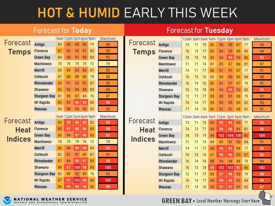
Northeast, central Wisconsin
Northeast and central Wisconsin are expected to see temperatures in the 90s Monday and Tuesday as well.
On Tuesday in Green Bay, heat indices are projected to crest 100 degrees, while in Wausau they could reach 97.
Thunderstorms possible
Scattered thunderstorms are possible late Tuesday afternoon and evening, according to the weather service. Lightning and damaging winds would be the main threats.
"It is possible that storms may not form at all," the weather service said in a notice. "Even if storms form, it is possible that most locations remain dry."
Contact Sophie Carson at (414) 223-5512 or scarson@gannett.com. Follow her on Twitter at @SCarson_News.
Our subscribers make this reporting possible. Please consider supporting local journalism by subscribing to the Journal Sentinel at jsonline.com/deal.
DOWNLOAD THE APP: Get the latest news, sports and more
This article originally appeared on Milwaukee Journal Sentinel: Wisconsin weather: Heat index to top 100 in Milwaukee, Green Bay

