Wisconsin weather live updates: Thousands still face power outages
Editor's note: The USA TODAY NETWORK-Wisconsin is making these severe weather updates free for everyone to read as a public service.
Strong winds are expected to last throughout the day Thursday before subsiding at night, according to the National Weather Service.
This comes after two tornadoes were confirmed in the state: one in Stanley and the other just north of Neillsville in west-central Wisconsin.
Roy Eckberg, a meteorologist at the National Weather Service in Green Bay, said the worst of the windstorm was overnight and continuing into Thursday morning, with strong winds all day and gusts of over 40 mph in the afternoon.
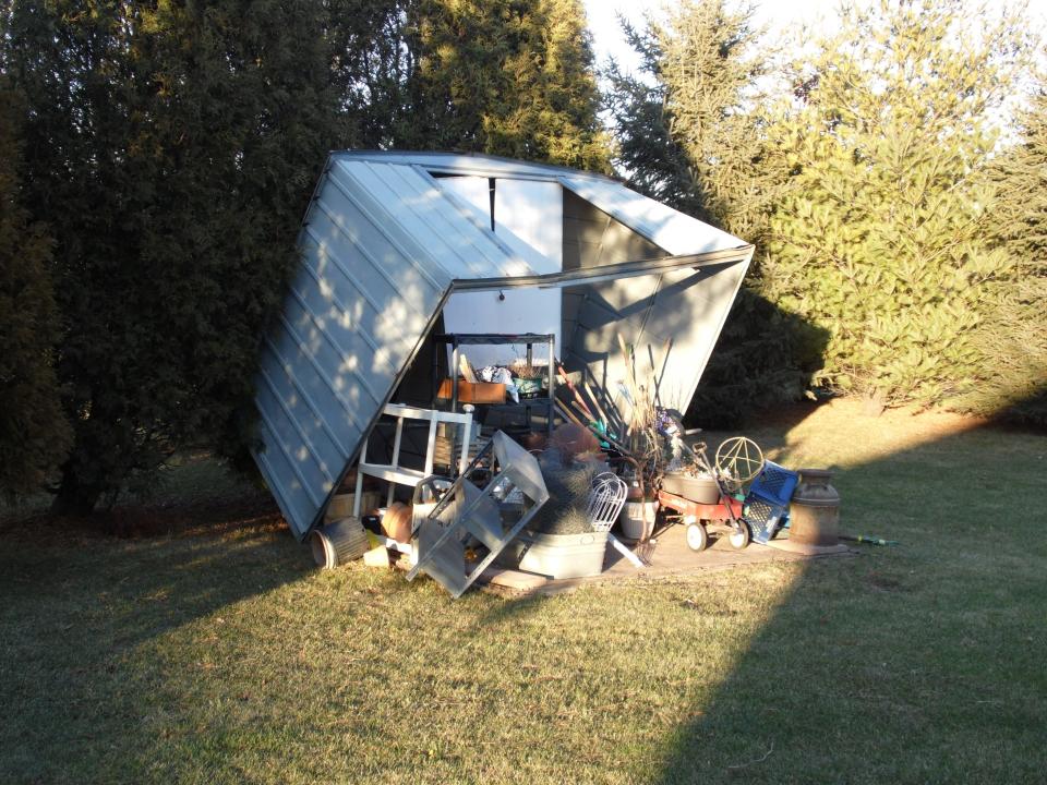
Some parts of the state had wind gusts exceeding 70 mph.
POWER OUTAGE MAPS: We Energies | Wisconsin Public Service | Alliant Energy
RELATED: Here's the latest on power outages in Wisconsin
After record highs were set in many cities in Wisconsin, cold weather moved in on Thursday with more seasonal temperatures and highs in the 30s.
As of 3:15 p.m. Thursday the following customers remained without power:
About 36,000 Wisconsin Public Service customers, around 43,400 We Energies customers and about 3,400 Alliant Energy customers.
Thousands still face power outages
As of 8 p.m. Thursday evening, some lingering power outages remained across the state.
Around 25,800 Wisconsin Public Service customers, 27,000 We Energies customers and 2,200 Alliant Energy customers are still affected by the outages.
For people without power overnight, warming stations are available in some cities. In Wausau, Fire Station #2, located at 3017 Seymour Lane, opened its doors Thursday night for anyone in need of a warm place during the ongoing outages.
Wind advisory for eastern half of Wisconsin expiring at 5 p.m.
The wind advisory issued by the National Weather Service for the eastern half of Wisconsin expired at 5 p.m. That was the last advisory, watch or warning issued as part of a historic December windstorm to expire.
The forecast for the remainder of the night calls for mostly clear skies with the temperature dropping to 22 in the Milwaukee area.
- Drake Bentley
Port Washington treatment plant lost primary power for over eight hours
4:05 p.m. In the city Port Washington, the city’s wastewater treatment plant had primary power knocked out from 3 11:30 a.m. Thursday and operated on backup power during that time, according to City of Port Washington director of public works and city engineer Rob Vanden Noven. He said primary power to the plant is back on.
Vanden Noven also said on the north side of Port Washington there were reports of some power outages but didn't know if there was more. He also said there were some wires down on the Interurban Trail north of downtown Port Washington, but to his knowledge, no one was hurt.
According to We Energies’ power outage map, the city of Port Washington currently has 456 customers without power and the nearby town of Port Washington has 240 customers without power.
Vanden Noven also said the city “picked up a limb here and there out of the street” but said there were no major tree failures.
- Alec Johnson
Tornado confirmed in Stanley
3:50 p.m. On Thursday afternoon, the National Weather Service in the Twin Cities confirmed a tornado hit Stanley. It's not known the strength of the tornado yet.
"The impact throughout the city is quite expansive, with numerous structures sustaining devastating loss," Police Chief Lance E. Weiland said in a Facebook post.
No injuries were reported.
- Christopher Kuhagen
Waukesha County reports some tree damage, minor power outages
12:10 p.m. In the city of Waukesha, a tree clipped the edge of a house, causing minor roof and gutter damage off Grandview Boulevard and Madison Street, near Lowell Elementary School. There were no injuries.
Though most of the city retained power, an outage at Moreland Boulevard and Highway 164 forced road detours for drivers briefly.
In the village of Mukwonago, the winds damaged trees, particularly some large pine trees in the area north of Phantom Lake near Spring Street, but the problem seemed to be contained to that area, said Ron Bittner, the village’s public works director.
Bittner knew of no widespread power outages locally, noting that the windstorm’s seasonal timing helped. “We’re lucky there were no leaves on the trees this time of year,” he said.
The winds were less kind to the town of Mukwonago, where 17 trees scattered throughout the town were reported down as of 11 a.m. Thursday, said Sgt. Eric Schmidt of the town’s Police Department.
Unfortunately, some of those trees caused problems.
“Two of them involved wires down, arching and that kind of stuff, and two involved either a car crashing into it or, in one case, maybe a tree fell on a car, but neither of them generated a (police) report,” Schmidt said.
In New Berlin, about a dozen trees fell into roadways, plus some additional trees blocking parts of the city’s recreational trail system, but all of those had been cleared by early afternoon Thursday, according to the mayor’s office. Roughly 1,200 people lost power.
- Jim Riccioli
EF-2 tornado reported in Clark County
12:05 p.m. Surveyors with the National Weather Service office in La Crosse have confirmed an EF-2 tornado north of Neillsville in Clark County.
Neillsville, roughly 50 miles southeast of Eau Claire, was one of three places so far where La Crosse-based surveyors confirmed a tornado was produced during overnight storms. An EF-0 tornado was confirmed near Lewiston, Minnesota, and an EF-1 hit Rudd, Iowa.
The weather service reported trees and power lines in Neillsville had fallen over roads and roofs were damaged.
An EF-2 tornado is one with winds of 111 to 135 mph.
The weather service also received a report of a funnel cloud Wednesday night roughly 15 miles east in Chili, Wisconsin.
Tornadoes are extremely rare for December in Wisconsin.
This tornado is the first December tornado since 1970 in Wisconsin, according to the National Weather Service.
That year, four tornadoes were recorded on Dec. 1 in central Wisconsin and another was recorded on Dec. 3 in Dodge County.
Reliable tornado recordkeeping in Wisconsin began in 1950. Weather service meteorologists say that Wednesday’s tornado was the latest to occur in the calendar year on record.
— Sophie Carson
Power outages could last into the weekend, We Energies says
11:25 a.m. In a statement late Thursday morning, We Energies acknowledged some power outages caused by Wednesday's windstorm could last into the weekend.
As of about 11 a.m., the utility had restored power to more than 80,000 customers, it said, but some 61,700 or so remained without power in southeastern Wisconsin, according to an outage map.
"With high winds continuing today we are seeing more outages and damage to our network. We expect to have restoration estimates later today when winds subside," said Brendan Conway, manager of media relations for We Energies. "Unfortunately repairs in some areas will take a longer period of time and customers should be prepared for an extended outage that could last into the early hours of the weekend."
Wisconsin cities set record December highs early Thursday
11:00 a.m. In Green Bay, a new record high for December was set early Thursday, according to the National Weather Service. On Wednesday, the high reached 64 just before midnight. That tied the previous all-time high that was first set on Dec. 5, 2001.
However, at 12:46 a.m. Thursday, that tie was erased when the temperature hit 65.
It was also “the latest 60-degree reading in a calendar year,” the National Weather Service reported. The previous mark was Dec. 8, 1946, when it hit 60.
After that, the temperature started dropping to the 30s by Thursday morning.
Several cities throughout Wisconsin set record high temperatures on Thursday. Some exceeded the record by 10 to 15 degrees. According to the National Weather Service in Green Bay, records set on Thursday included:
• Antigo: 51 (43, set in 1894 and 1913)
• Green Bay: 65 (49 in 1998)
• Marshfield: 59 (47 in 1997)
• Oshkosh: 63 (51 in 1984)
• Rhinelander: 54 (48 in 1993)
• Wausau: 58 (48 in 1997)
• Wisconsin Rapids: 63 (49 in 1923)
Some areas also set record high minimum temperatures. They included:
• Green Bay: 39 (tied 39 set in 2014)
• Manitowoc: 42 (39 in 1928 and 1998)
• Oshkosh: 45 (40 in 2014)
• Rhinelander: 37 (tied 37 in 2014)
• Wausau: 39 (tied 39 in 2014)
Milwaukee Public Library staff prepare for possible influx of students
10:45 a.m. Milwaukee Public Library staff rushed to prepare various library branches Thursday morning for a possible influx of local students following widespread power outages that forced more than a dozen Milwaukee Public Schools to move to virtual learning.
Eileen Force Cahill, MPL community relations director, said library staff were readying to welcome students when most branches open at 11 a.m. Staff said there had not been coordination in advance with MPS but the libraries were prepared to help.
"We will accommodate as many students as we can today," Force Cahill said. "We have a shared partnership with MPS to serve the youth of the community and we absolutely have wide open doors."
Fourteen Milwaukee Public Schools closed Thursday due to power outages from overnight high winds.
Sheboygan reports 66 mph wind, highest in southern Wisconsin
10:25 a.m. Sixteen locations in southern Wisconsin experienced winds surpassing 50 and 60 miles an hour during a windstorm that carried over into Thursday morning, according to the National Weather Service in Milwaukee.
As of 6 a.m., the highest wind speed of 66 miles an hour was recorded at the Sheboygan County Memorial Airport. Milwaukee, Kenosha, Racine, Fond du Lac and rural Sauk County also experienced winds of 60 miles an hour or more.
Other communities with recorded wind speeds between 50 and 59 miles an hour include Madison, Monroe, Waukesha, Baraboo, East Troy, Middleton, Juneau, West Bend, Reedsburg and Watertown.
Burlington and Janesville recorded wind speeds as high as 48 and 47 miles an hour.
— Elliot Hughes
High winds to continue through the day
10:20 a.m. Southern Wisconsin residents can expect blustery conditions to continue through Thursday, the National Weather Service said.
A wind advisory remains in effect until 5 p.m. for much of southern and central Wisconsin. Lingering gusts of up to 45 mph will be possible.
Colder air is working its way into the region with temperatures expected to hover in the mid-30s to low 40s, with wind chills in the 20s, the weather service said.
MPS students without power should go to public libraries for virtual school
9:45 a.m. Public school students in Milwaukee whose school has shifted online but do not have power at home after the powerful windstorm are being encouraged to visit public libraries for virtual learning.
Milwaukee Public Schools forwarded the same advice to staff who also do not have power in their homes.
Most public libraries in Milwaukee, however, do not open until 11 a.m.
Last night’s windstorm has knocked out power for nearly 49,000 people in the Milwaukee area as of 9:30 a.m. Thursday, according to an outage map from We Energies.
The outages forced 14 public schools in Milwaukee to shift to online learning Thursday.
In a news release, Milwaukee Public Schools indicated that students and staff in affected schools can expect additional outreach from their child’s teacher for instructions on virtual learning.
— Elliot Hughes
Downed trees strike homes in southern Wisconsin, large structural damage avoided
9:13 a.m. The bulk of damages reported in the Milwaukee area, and southern Wisconsin in general, from the windstorm overnight appears to have mostly amounted to downed trees and power lines, according to the National Weather Service in Sullivan.
A map of storm reports maintained by the National Weather Service shows downed tree limbs in Brown Deer, Waukesha and Slinger.
“In comparison to everywhere west and south of us, we didn’t have nearly as many downed trees or downed power lines,” said meteorologist Taylor Patterson, referring to southern Wisconsin.
The National Weather Service map indicated some of those downed trees did strike homes. Around 11 p.m. Wednesday in Slinger, a “very large” tree branch fell on a house near Highway 60 and Slinger Road.
Another tree limb reportedly fell on a home in Middleton shortly after 4:30 a.m.
Still, Patterson said the region had largely escaped “big structural damage.”
Power outages cause school closures
8:27 a.m. As of 7:35 a.m. Thursday, 14 Milwaukee Public Schools have moved to virtual learning Thursday after high winds overnight caused power outages affecting 77,000 people throughout the city.
The move affects the following schools:
Brown Street Academy
Grant Gordon Learning Center
Albert E. Kagel School
Escuela Vieau
Lloyd Barbee Montessori School
James Fenimore Cooper School
Ralph Waldo Emerson School
Humboldt Park School
Milwaukee Parkside School for the Arts
Frances Starms Discovery Learning Center
Starms Early Childhood Center
Oliver Wendell Holmes School
Dr. George W. Carver Academy of Mathematics and Science
James E. Groppi High School
In northeastern Wisconsin, classes were canceled or are in a two-hour delay:
Crivitz (two-hour delay)
Crandon
D.C. Everest (two-hour delay)
Freedom
Gibraltar (two-hour delay)
Green Bay School District Head Start Learning Center in Bellevue
Greenwood
Marathon
Menomine Indian Head Start
Menominee Indian (two-hour delay)
Merrill
Neillsville (two-hour delay)
Oconto Falls (two-hour delay)
Port Edwards
Pulaski
Rhinelander
Sevastopol (two-hour delay)
Shawano (two-hour delay)
Stanley Boyd
Tigerton (two-hour delay)
Tomahawk
Wabeno (tour-hour delay)
Waupaca
Wausaukee (two-hour delay)
Stanley police report widespread damage; schools in area closed
6 a.m.: The Stanley Police Department reported damage across the community early Thursday as a result of the late-night storm that swept through Chippewa and Clark counties on its march across the state.
The police department, on its Facebook page, said about 75% of Excel Energy customers had been without power since 9:15 p.m. Wednesday as utility crews were "working feverishly" to restore service.
The department advised people to "resist the temptation" to travel around Stanley on Thursday morning to see the damage because of the danger of downed and active power lines.
Police also posted photos showing some of the damage, but reported no known deaths or injuries.
The department said Stanley-Boyd schools would be closed Thursday. Nearby Thorp also closed schools for the day because of a power outage.
RELATED: Tornadoes and 100 mph winds hit Central US
Gusts in the 60s and 70s recorded in spots
5:50 a.m.: The National Weather Service in Green Bay reported that peak wind gusts reached 76 mph in Rhinelander and 74 mph in Marshfield, as well as 62 mph in Wausau and 60 mph in Ashwaubenon.
"This may not be the peak gusts as many locations are still gusting near these values," the weather service posted on Twitter, where it shared peak gusts recorded as of 4 a.m. Thursday.
Here is a look at some of the highest wind reports that we've seen over the past 6 hours (as of 4 am 12/16) across northeast Wisconsin! This may not be the peak gusts as many locations are still gusting near these values. Look for updated peak winds later today! #wiwx pic.twitter.com/fuBz5GFzrh
— NWS Green Bay (@NWSGreenBay) December 16, 2021
Strong winds move into eastern Wisconsin
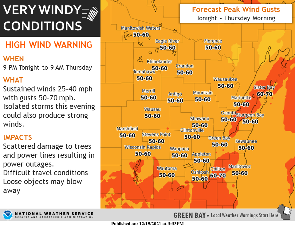
11:31 p.m. The storm system that sped across the state moved into eastern Wisconsin late Wednesday. The National Weather Service reported "very strong winds will accompany a band of showers" into the early hours of Thursday. The area could see wind gusts as high as 50 to 60 mph.
The affected counties include Forence, Menominee, Door, Shawano, Outagamie, Brown, Kewaunee, Calumet, Manitowoc, Marinette and Oconto
The high wind warning is in effect until 9 a.m. Thursday.
WPS reports outages in central Wisconsin
11:23 p.m. In the aftermath of the storm front, Wisconsin Public Service is dealing with power outages from Stevens Point to Eagle River in central and northern Wisconsin.
About 4,500 outages were reported in Portage County and almost 3,800 in Marathon County. A total of 17,197 outages were reported in WPS service area as of 11:23 p.m.
Severe thunderstorm warnings move west
10:45 p.m. The National Weather Service issued a severe thunderstorm warning for parts of Forest, Oneida, Waupaca, Oconto and Shawano counties as well as Menominee and Langlade counties.
The front was moving northeast at 65 mph and could contain wind gusts of 70 mph.
Once the storm front moves through, strong windstorms are still expected behind it.
Wind gusts in Marshfield, Wisconsin Rapids
10:19 p.m. The National Weather Service reported wind gusts of 69 mph at the airport in Wisconsin Rapids and 54 mph at the airport in Marshfield. The weather service urged people in the line of the storm to seek shelter.
A wind gust of 69 mph was just reported at the airport in Wisconsin Rapids!!! Seek shelter as the line of severe storms heads east across the area!! #wiwx
— NWS Green Bay (@NWSGreenBay) December 16, 2021
Thunderstorm warning for 6 counties
9:55 p.m. A thunderstorm warning has been issued for Langlade, Lincoln, Marathon, Portage, Waushara and Wood counties until 11 p.m.
ReadyWisconsin Alert Severe Thunderstorm Warning for Langlade, Lincoln, Marathon, Portage, Waushara and Wood County until 11:00pm. This is a ReadyWisconsin Alert #WIWX
— ReadyWisconsin (@ReadyWisconsin) December 16, 2021
Leo Frigo bridge warning in Green Bay
9:41 p.m. Green Bay Police warned drivers to avoid the Leo Frigo Memorial Bridge when high winds are present. "If wind thresholds get met tonight, there may be a bridge closure," the police said.
Severe thunderstorm watches for central, southern, eastern Wisconsin
9:37 p.m. The National Weather Service has extended its severe thunderstorm watches to 28 counties as the storm enters central Wisconsin. The storm is moving about 60-70 mph.
The thunderstorm watch is in effect until 1 .am. Thursday for the following B counties: Brown, Calumet, Columbia, Dane, Dodge, Door, Fond du Lac, Forest, Green, Green Lake, Jefferson, Kewaunee, Langlade, Lincoln, Manitowoc, Marinette, Menominee, Oconto, Oneida, Outagamie, Rock, Shawano, Sheboygan, Walworth, Washington, Waukesha, Waupaca and Winnebago.
937 PM | Severe Thunderstorms are entering central WI. Yellow boxes show Severe Thunderstorm Warnings. Red boxes show Tornado Warnings. Storms are moving about 60-70 mph. Storms will quickly across the area late this evening. Seek shelter when storms approach! #wiwx pic.twitter.com/vzGe1b1kpD
— NWS Green Bay (@NWSGreenBay) December 16, 2021
Tornado warning for Clark County
9:15 p.m. The National Weather Service issued a tornado warning for Clark and Taylor county until 10 p.m. due to a "severe squall line capable of producing both tornadoes and extensive straight line wind damage" near Neillsville. It was moving northeast at 80 mph.
ReadyWisconsin Alert Tornado Warning for Clark County until 9:45pm. This is a ReadyWisconsin Alert #WIWX
— ReadyWisconsin (@ReadyWisconsin) December 16, 2021
Storm moves into central Wisconsin
9:05 p.m. The leading edge of the storms was about 20 miles from the Wood County border, according to a Facebook post from the the National Weather Service in Green Bay.
It is scheduled to reach the Fox Valley and Green Bay between 11 p.m. and midnight.
Tornado watch issued for central, western
Thirty-four counties were under a tornado watch, the National Weather Service issued Wednesday evening. The watches began at 5:30 p.m. and run until 11 p.m.
The counties under the tornado watch are Adams, Barron, Buffalo, Chippewa, Clark, Columbia, Crawford, Dane, Dunn, Eau Claire, Grant, Green, Green Lake, Iowa, Jackson, Juneau, Lafayette, La Crosse Marathon, Marquette, Monroe, Pepin, Pierce, Polk, Portage, Richland, Rusk, Sauk, St. Croix, Taylor, Trempeleau, Vernon, Waushara and Wood.
A high wind warning will go into effect at 9 p.m. Wednesday until 9 a.m. Thursday for Waushara, Calumet, Winnebago, Brown, Outagamie and Waupaca counties, which can expect southwest winds of 25 to 35 miles per hour with gusts reaching up to 60 mph.
These high winds may be damaging, potentially blowing down trees and power lines. The National Weather Service said some power outages should be expected, and driving may be treacherous for high-profile vehicles.
The National Weather Service advises people to take precautions and stay in the lower parts of homes and try to avoid windows during the windstorms.
RELATED: 7 things Wisconsin DOT wants you to know about driving in windstorm
The strong winds are also creating a storm warning affecting the nearshore water of Lake Michigan from Washington Island to Sheboygan, beginning 9 p.m. Wednesday and lasting until noon Thursday. Large waves may reach 12 to 17 feet.
Dense fog continues to reduce visibility Wednesday evening, especially where there is snow on the ground.
Contact Kelli Arseneau at (920) 213-3721 or karseneau@gannett.com. Follow her on Twitter at @ArseneauKelli.
This article originally appeared on Green Bay Press-Gazette: Wisconsin weather live updates: Thousands still face power outages

