Wisconsin weather updates: Live snow totals, power outages, road closures and more winter storm updates Tuesday
A winter storm has made its way to Wisconsin. Many schools closed for the day.
A winter storm warning is in effect all Tuesday through Wednesday morning for much of the state. Snow arrived in the state overnight on Monday from the Central Great Plains and impacted morning and evening commutes. Check out current road conditions at 511wi.gov.
We'll update this file with the latest on the winter storm and the situation around Wisconsin with snowfall totals, school closings, road conditions and any power outages.
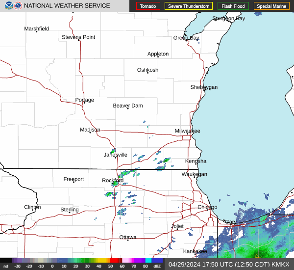
Take a look at Wisconsin's weather radar
See what kind of precipitation is falling across Wisconsin here:
10:10 p.m.: Latest snowfall totals for Wisconsin
A small village with a population less than 1,000 people located in Lafayette County in southwestern Wisconsin, Benton, recorded 10 inches of snow, according to the National Weather Service.
Here are the most recent snow totals across Wisconsin:
Benton: 10 inches
Verona: 8 inches
Redgranite: 8 inches
Plymouth: 7 inches
Waupaca: 7 inches
Clayton: 6.5 inches
Richfield: 5.7 inches
Buckhorn State Park: 4.9 inches
Clintonville: 4.5 inches
Plover: 3.6 inches
Peshtigo: 3.5 inches
West Salem: 3.1 inches
Knowlton: 2.6 inches
Muskego: 2 inches
Kohler: 1.2 inches
9:15 p.m.: Snow will slow down shortly after midnight; 'powerful storm' headed to Wisconsin Friday
Tuesday's storm, which brought several inches of snow to parts of Wisconsin, will slowly move out of Milwaukee metro area overnight.
"If you're within a few miles of the lake, there's gonna be very little snow on the ground," said meteorologist Mark Gehring with the National Weather Service.
Gehring notes that many parts of southwestern Wisconsin received 6 to 9 inches of snow but much of Milwaukee will have about an inch of snow on the ground by morning.
Another storm is headed to Wisconsin with its sights set on Friday night, Gehring said. "This is a very powerful storm," he said.
Gehring said he can say with certainty that it will snow on Friday, but it's too early to tell how much snow will fall on the state. Early projection for Milwaukee, though is a little more than an inch, according to the National Weather Service.
8:30 p.m.: 21 crashes on Milwaukee County highways
The Milwaukee County Sheriff's Office has received 56 calls for service as of 8 p.m. on the area's freeways Tuesday.
The sheriff's office reported 21 crashes, with one of the crashes resulting in injuries. Deputies responded to 27 calls for a disabled vehicle and four calls for debris or hazard on the highway.
6:10 p.m.: More than 16,000 without power across Wisconsin
Tuesday's storm has began to result in power outages for Wisconsin residents.
We Energies, the utility company for much of southeastern Wisconsin and the Fox Valley reports more than 10,000 people are without power as of 6 p.m. Tuesday.
Alliant Energy, which covers much of central and southern Wisconsin, including Madison, reports more than 3,600 customer affected. And the Wisconsin Public Service, covering northern Wisconsin, including Green Bay, reports more than 2,800 residents without power.
5:15 p.m.: Snow totals reach 9 inches in southwestern Wisconsin
Here are recent snow totals across Wisconsin, according to the National Weather Service:
Eastman: 9 inches
Hillsboro: 7 inches
Platteville: 6.5 inches
Dodgeville: 6.5 inches
Seneca: 6 inches
White Creek: 6 inches
Mineral Point: 5.5 inches
Tomah: 4.5 inches
Merrill: 1.5 inches
5 p.m.: Officials ask residents to be mindful of parking regulations for plows as the heavier snow begins to fall
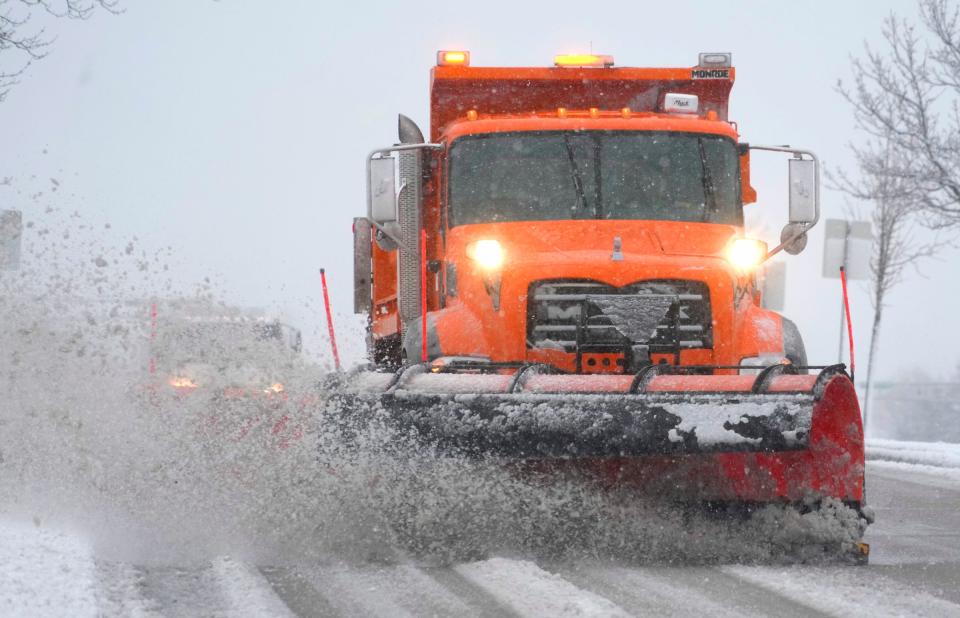
About 100 plow truck drivers working 12-hour shifts have been tending to Milwaukee's streets since 9 p.m. Monday. A Department of Public Works official provided an update Tuesday afternoon.
Tiffany Shepherd, department spokesperson, said, "(snow) will continue to be heavier in the afternoon and evening. So we just urge people to please drive safe. Please give our crews ... space. And, most importantly, please be patient."
DPW salt and plow trucks will travel along 7,000 miles of road.
Shepherd asked that people please obey city parking regulations so plows can clear the street. "Sometimes people have concerns about the east side, about how those streets might look. You have to remember, our plows only have so much space to get down and clear."
4 p.m.: Milwaukee Health Department closes early; shelters available
Milwaukee Health Department offices and clinics closed at 3:30 p.m. Tuesday because of the winter storm.
Closings took place at the Zeidler Municipal Building, Keenan Sexual Health Clinic, Southside Health Center and Northwest Health Center, according to a statement from the department.
All locations were expected to reopen Wednesday for normal operations, but that could change depending on the weather.
Those who need shelter overnight can find it at warming shelters, according to the Health Department:
Guest House Milwaukee (Men only), 1216 N. 13th St. Walk-ins only, 7-10 p.m. intake, can stay from 7 p.m. to 7 a.m.
MRM/Joy House/Door of Hope (Men, Women, Families), 819 N. 18th St. Call ahead for shelter space: (414) 344-2211
St. Ben’s (Men and Women), 930 W. State St. Walk-ins only, 8-10 p.m. intake, can stay from 7 p.m. to 7 a.m.
Repairers of the Breach (Men and Women), 1335 W. Vilet St. Walk-ins only, 8-10 p.m. intake, can stay from 7 p.m. to 7 a.m.
Milwaukee County Hillview (Men and Women), 1615 S. 22nd St. Walk-ins only, 7 p.m. to 7 a.m.
— Alison Dirr
2:50 p.m. Milwaukee area road conditions worsen ahead of evening commute
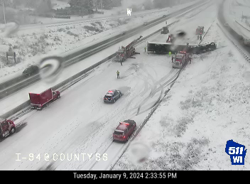
Crashes and disabled vehicles have been reported on the highways in the Milwaukee area throughout the day, but now there is a complete closure on I-94's westbound lanes in Waukesha County due to a semitruck rollover. Crews are on scene and attempting to remove the obstruction.
All lanes of traffic was reopened to traffic by around 4 p.m.
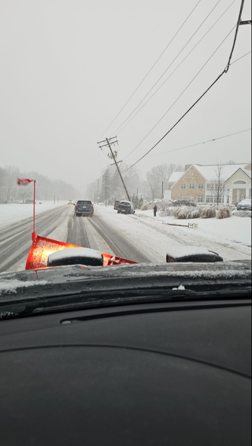
Heading into rush hour, the roads are getting icy and slippery. According to Wisconsin 511, almost all of the roads and highways in Milwaukee, Racine, Washington and Waukesha counties have been designated as having "slippery stretches" or are "snow covered."
With the snow expected to peak this afternoon, conditions are expected to get worse.
— Drew Dawson
1:30 p.m.: Latest snow totals across Wisconsin
Snow continues to fall across Wisconsin. In southeast and northeast Wisconsin, meteorologists expect the heaviest snow to fall in the afternoon and evening hours.
Communities along Lake Michigan have seen little accumulation of snow compared to cities farther west, but rain on the lakeshore could change to snow during the afternoon.
Most highways across the southern part of the state have slippery stretches, according to the Wisconsin Department of Transportation. The right two lanes of Interstate 94 west at County SS near Pewaukee because of a crash. And all lanes of I-94 north at State 158 near Kenosha were blocked because of another crash.
In Green Bay and Fox Valley, driving conditions were deteriorating as heavier snow moved in and winds picked up, the National Weather Service said. There was a half-mile of visibility.
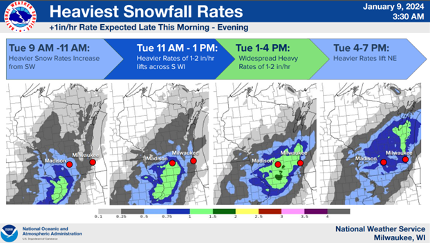
Snowfall rates of 1 inch or more per hour are possible as the system moves north and east, the weather service said.
Here are the latest snow totals, according to the weather service:
Sussex: 3.5 inches
Waukesha: 3 inches
Dane County Regional Airport (Maple Bluff): 1.3 inches
Dundee: 3 inches
Combined Locks: 2.2 inches
Tomah: 3.8 inches
Mauston: 5.4 inches
Boscobel: 6.5 inches
Muscoda: 8 inches
Right now, about 10 miles apart. Bayside, near the lake, no snow. Menomonee Falls, a couple inches. #wiwx pic.twitter.com/rNCyKMNFrd
— Mike De Sisti (@mdesisti) January 9, 2024
11 a.m.: How does Lake Michigan affect snow in Milwaukee?
While lake-effect snow events do happen in Milwaukee, they are pretty rare compared to other cities across the Great Lakes.
For lake-effect snow to happen cold air needs to travel across warm water. A cold, dry air mass will soak up moisture and heat from the lakes like a sponge. The larger the temperature difference between the air and water, the heavier the snowfall. The magic number is at least a 23 degree temperature difference between the water and air at 5,000 feet.
Another important factor is the fetch – or the distance that wind travels over water. The longer the fetch, the more time there is to suck up warm water along the way. And depending on the wind direction, these air masses can spend a lot of time over open water.
When the moist, warmed air finally hits land, it cools and dumps heavy snow. These events typically happen in the late fall and early winter when the lakes are ice-free and the water is still relatively warm. Ice acts as a barrier preventing the air mass from soaking up moisture.
Because the jet stream typically moves from west to east, the eastern side of the Great Lakes are especially susceptible to lake-effect snow. While the ingredients, like cold air and warm water, are there in Milwaukee, the wind direction usually isn’t, said Steve Vavrus, Wisconsin state climatologist.
— Caitlin Looby and Steven Martinez
10:15 a.m.: What's the forecast for the coming days?
Another potential system could bring snow to Wisconsin Friday, but it's too early to predict specifics on timing and amount of snowfall.
Big questions remain on the track of the storm, said Taylor Patterson, meteorologist with the National Weather Service in Sullivan. It could track farther south, giving southeast Wisconsin less snow.
And lakefront counties could see higher snowfall totals if winds from the northeast provide lake-enhanced snow.
Then, heading into the weekend, temperatures will begin to drop, Patterson said.
Friday night into Saturday, temperatures will fall into the teens and will continue to drop into the single digits throughout the day. In Madison and to the west, temperatures could dip below zero.
On Sunday, highs will be around 10 to 15 degrees. Overnight into Monday, temperatures will be below zero. Wind chills will be coldest then, potentially as low as minus-20 degrees.
10:10 a.m.: Where can I find the latest Wisconsin winter weather road conditions?
Check out the the 511 WI website for the latest traffic updates and any road closures across Wisconsin. Stay up to date via their X/Twitter account.
10 a.m.: Latest snowfall totals across Wisconsin
Here are some of the latest snowfall totals from the National Weather Service:
Platteville: 3 inches
Oshkosh: 2 inches
Elkhorn: 2.5 inches
Viroqua: 5.3 inches
Chilton: 1 inch
Sullivan: 1.6 inches
7:50 a.m.: Heavy, wet snow expected across southern Wisconsin
Relatively light precipitation in the early-morning hours is transitioning to heavier, wetter snow across the state as the morning continues, said Marcia Cronce, meteorologist with the National Weather Service in Sullivan.
Snowfall rates of 1 inch per hour, and even up to 2 inches per hour, will be possible in the storm's bands of heavy snow, with the heaviest snowfall in the afternoon and evening, Cronce said.
"If you don't have to travel this afternoon, I would avoid that," she said.
Wind gusts of 35 mph mean the wet, heavy snow could be blown onto trees. And trees laden with heavy snow could snap, potentially knocking down power lines. Sporadic power outages are possible as well.
The wet snow will turn to lighter, fluffier snow overnight as the storm tapers off. That fluffy snow will easily blow over the road, reducing visibility, Cronce said.
7:45 a.m.: Milwaukee-area road conditions clear so far
No weather-related closures or crashes have stalled morning commute traffic Tuesday in and around Milwaukee.
The Wisconsin Department of Transportation indicates there are some slippery stretches, mostly in southwestern Milwaukee and Waukesha counties, but otherwise road conditions remain good for winter driving as of 7:45 a.m.
However, Highway 18, from Jefferson to the Waukesha County line, is covered with ice, 511 Wisconsin shows. Drivers should proceed with caution there or avoid the area if possible.

6:45 a.m.: Latest forecast predicts strong winds, low visibility, poor driving conditions
As the storm moves east across the state, roads in southwest Wisconsin were snow-covered, according to the Wisconsin Department of Transportation. The National Weather Service reported 3.9 inches of snow had fallen in De Soto, on the border with Iowa, and 2.4 inches in La Crosse.
Highways around Madison and east to the Milwaukee area had slippery stretches. Close to the city of Milwaukee, the Wisconsin Department of Transportation said there were good winter driving conditions, as rain was mostly falling near Lake Michigan.

In south-central and southeast Wisconsin, the heaviest snowfall will begin after 9 a.m., the weather service said, with accumulations of 6 to 12 inches. There's the potential for rain and snow to mix along the lakefront.
Travel could be very difficult throughout the day, the weather service said, as patchy and blowing snow will reduce visibility and affect the afternoon and evening commutes especially. Wind gusts up to 35 mph are expected.
Milwaukee's Department of Public Works said its trucks had begun salting the roads overnight. About 100 trucks are expected to be out working throughout the day.
About 2.5 inches of snow had fallen in Elkhorn by 6:30 a.m., according to the weather service.
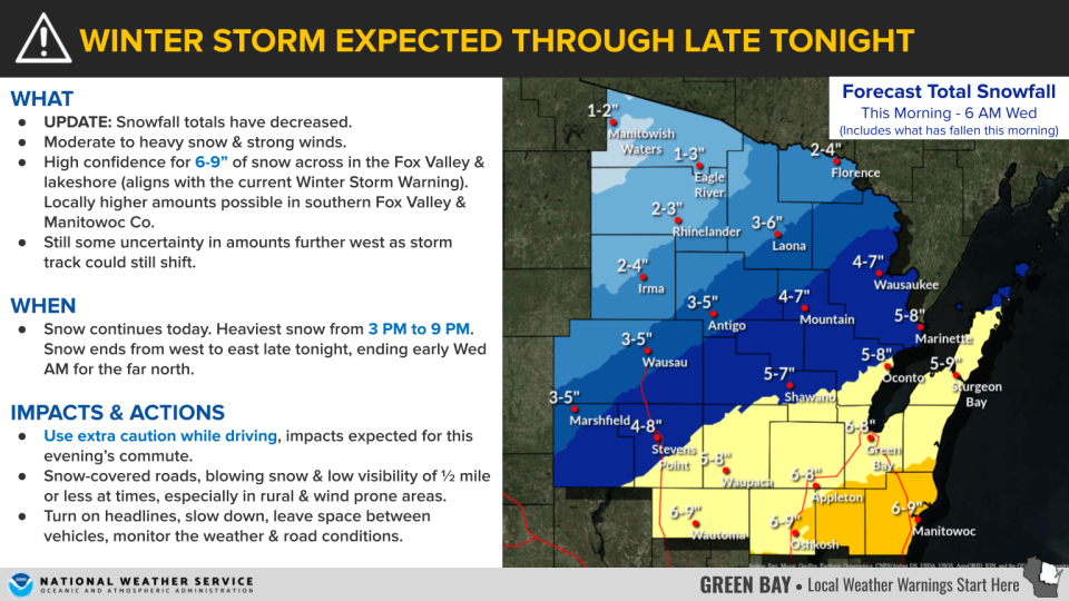
In northeast Wisconsin, weather service meteorologists said they have high confidence in predicting 6 to 9 inches of snow, with higher amounts in the southern Fox Valley and in Manitowoc County. The heaviest snow is expected 3 p.m. to 9 p.m. Snow-covered roads, blowing snow and visibility of a half-mile or less is expected, with poor driving conditions in rural and windy areas.
North-central communities of Wausau and Marshfield are expecting 3-5 inches of snow.
6 a.m.: Milwaukee Public Schools cancels classes
All Milwaukee Public Schools buildings will be closed Tuesday, and all after-school, recreation and athletic programs are canceled. The school board meeting set for Tuesday evening will be held virtually.
Here is a list of Milwaukee-area school closures and a list of Green Bay-area closures.
Wisconsin weather warnings
Steven Martinez of the Milwaukee Journal Sentinel staff contributed to this report.
This article originally appeared on Milwaukee Journal Sentinel: Wisconsin live snow updates: forecast, radar, totals, power outages

