Yes, Indianapolis was hit by a 'derecho' Thursday. Here's what that means.
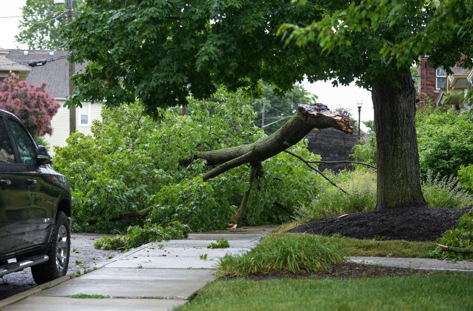
A powerful wind storm known as a "derecho" howled across Central Indiana where it slammed into Indianapolis on Thursday afternoon, damaging trees and cutting power to hundreds of thousands of Hoosiers.
More than 139,000 customers remained without power about 8 a.m. Friday morning.
Power outages: What you should and shouldn't be doing when the lights go out
What is a derecho?
A derecho (pronounced 'deh-REY-cho') is a windstorm spread over hundreds of miles that moves in one direction along a relatively straight path and can produce destruction similar to a tornado, according to the National Weather Service.
"Essentially, it's a complex line of storms at least 240 miles long with severe wind gusts greater than 58 mph along the storm's path, and where wind gusts are greater than 70 mph," said Andrew White, a meteorologist with NWS in Indianapolis.
Experts use the term "straight-line wind damage" to describe the punishing destruction left in the wake of a derecho.
Why is it called a derecho?
The usage of "derecho" to describe these powerful storms was coined in 1888 by Dr. Gustavus Hinrichs, a professor of physics at the University of Iowa. Hinrichs used the term in a paper published by the American Meteorological Journal to distinguish thunderstorm-induced straight-line winds from the damaging, rotary winds of tornadoes, according to NWS.
The word "derecho" is Spanish in origin. Its English translation means "right," "direct," or "straight ahead."
Could another derecho hit Indianapolis this weekend?
White said meteorologists on Friday were paying careful attention to thunderstorms near Illinois, but said those storms weren't near the intensity of what Hoosiers saw Thursday. Nonetheless, more severe weather is expected for Central Indiana going into the weekend.
"The best chance for the most intense storms looks to be Saturday afternoon and evening," White said. "We're expecting additional thunderstorms on Sunday, so we're kind of just in this very active pattern where round after round of storms will be moving through the area."
As Hoosiers celebrate Fourth of July weekend, White recommended people keep a careful watch on the skies.
"With the potential for strong and severe storms, we always want everyone just to be a little bit more aware than they would normally be," White said.
More: Expect damaging winds, storms ahead of July 4 that could slow power restoration efforts
NWS weather outlook for Central Indiana this weekend calls for more storms
Saturday: Scattered showers and thunderstorms. Mostly cloudy, with a high near 88. Light southwest wind increasing to 5-10 mph in the morning. Chance of precipitation is 40%.
Saturday Night: Showers and possibly a thunderstorm. Low around 69. Southwest wind around 10 mph. Chance of precipitation is 90%. New rainfall amounts between a half and three quarters of an inch possible.
Sunday: Showers and possibly a thunderstorm. High near 81. West southwest wind 8-13 mph, with gusts as high as 20 mph. Chance of precipitation is 80%. New rainfall amounts between a quarter and half of an inch possible.
Sunday Night: Showers and possibly a thunderstorm, mainly before 2 a.m., then a chance of showers and thunderstorms after 2 a.m. Low around 66. Chance of precipitation is 80%. New rainfall amounts between a quarter and half of an inch possible.
Monday: A 50 percent chance of showers and thunderstorms. Mostly sunny, with a high near 83.
Monday Night: Mostly clear, with a low around 65.
Tuesday, Fourth of July: A 20 percent chance of showers and thunderstorms after 2pm. Sunny, with a high near 87.
Tuesday Night: A 10 percent chance of showers and thunderstorms before 8pm. Mostly clear, with a low around 67.
Wednesday: A 30 percent chance of showers and thunderstorms. Mostly sunny, with a high near 89.
Wednesday Night: A 40 percent chance of showers and thunderstorms. Partly cloudy, with a low around 68.
Thursday: Showers and thunderstorms likely. Partly sunny, with a high near 86. Chance of precipitation is 60%.
This article originally appeared on Indianapolis Star: Derecho hits Indianapolis with 70 mph wind gusts Thursday

