Zeta is now a Cat 1 hurricane, and the Florida Panhandle is under a tropical storm watch
Zeta is now a Category 1 hurricane, prompting tropical storm and hurricane watches from Louisiana to the Florida Panhandle ahead of a Wednesday landfall.
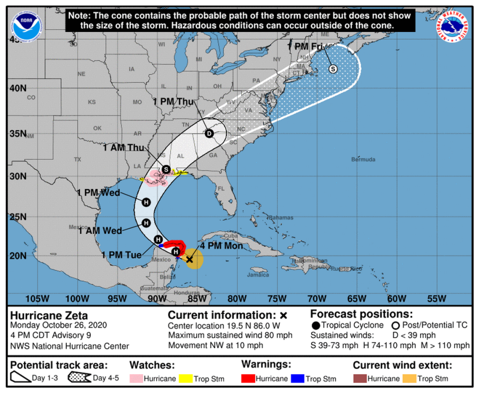
As of 11 p.m. Monday, Zeta is moving toward the northwest near 13 mph with maximum sustained winds near 80 mph with higher gusts, according to the hurricane center. The storm is about 40 miles east of Tulum, Mexico, and its hurricane-force winds extend 45 miles out from the center, while its tropical-storm-force winds extend outward up to 140 miles from the center.
Forecasters expect the storm will pick up speed and see additional strengthening until it moves over the Yucatan Peninsula late Monday, where it is expected to make landfall. By 11 p.m., the Yucatan began seeing heavy rains and wind, according to the hurricane center.
According to the projected track, the center of Zeta will then move into the southern Gulf of Mexico, where conditions are conducive for re-strengthening, and make a turn to the north, forecasters said. Zeta is then expected to approach the northern Gulf Coast on Wednesday, where it is expected to make a second landfall.
Here's the track and intensity forecast for #Zeta. Landfall possible tonight for the #Yucatan then a second landfall possible somewhere in the northern Gulf of Mexico. Deja Vu. Stay with @nbc6https://t.co/PKdbgxwLAa pic.twitter.com/21I5inillb
— Adam Berg (@AdamBergNBC6) October 26, 2020
Zeta’s forecast track is similar to Hurricane Delta’s, which also struck the Yucatan Peninsula in Mexico before hitting the U.S. Gulf Coast on Oct. 9.
But unlike Delta, which struck the Yucatan Peninsula and the U.S. Gulf Coast as a Category 2 hurricane, increasing shear and cooler waters in the northern Gulf are expected to reduce Zeta’s intensity before it reaches the northern Gulf Coast, forecasters said.
That would keep the storm at or near Category 1 hurricane-level strength. There is a risk of storm surge, rain and wind from Louisiana to the Florida Panhandle, according to the hurricane center.
“Residents in these areas should monitor the progress of Zeta and updates to the forecast,” forecasters wrote.
What type of weather will Zeta bring?
Hurricane conditions, including strong winds, rain and dangerous storm surge up to 3 feet and tropical storm conditions are expected by late Monday within the hurricane warning area of the Yucatan Peninsula, and the tropical storm warning area in Mexico from south of Tulum to Punta Allen and from west of Dzilam to Progreso.
Zeta is forecast to bring 4 to 8 inches of rain, with some areas possibly seeing up to 12 inches through Tuesday across the Yucatan Peninsula, the Cayman Islands and central to western Cuba.
From Tuesday night to Thursday, 2 to 4 inches of rain are expected across portions of the central U.S. Gulf Coast, Tennessee Valley, southern Appalachians and Mid-Atlantic States, according to the hurricane center. Some isolated areas may see up to 6 inches of rain.
The rainfall could lead to flash, urban and small-stream flooding, including minor river flooding, forecasters said. The worst of the storm-surge flooding, around 4 to 6 feet, is expected from Port Fourchon, Louisiana, to Dauphin Island, Alabama.
Zeta is the 11th hurricane of the 2020 season and the 27th named storm. This year is still one storm away from tying 2005’s record of 28 named storms. In 2005, Hurricane Zeta formed on Dec. 30 and was the final storm of the year, but in post-season analysis, the hurricane center re-classified an unnamed storm from earlier in the year, bringing the total to 28.
Zeta Watches/Warnings
▪ Mexico extended its hurricane warning west along the northern coast of the Yucatan peninsula to Dzilam. Cozumel is also under a hurricane warning.
▪ Mexico has also issued a hurricane warning from south of Tulum to Punta Allen and from west of Dzilam to Progreso.
▪ A storm-surge watch is in effect for Intracoastal City, Louisiana, to Navarre, Florida, as well as Lake Borgne, Lake Pontchartrain and Vermilion Bay in Louisiana, Pensacola Bay in Florida, and Mobile Bay in Alabama.
▪ A Hurricane Watch is in effect for Morgan City, Louisiana, to the Mississippi/Alabama border, as well as Lake Pontchartrain, Lake Maurepas, and Metropolitan New Orleans.
▪ A Tropical Storm Watch is in effect from the Mississippi/Alabama border to the Okaloosa/Walton County Line in Florida, in addition to the west of Morgan City to Intracoastal City Louisiana.

