Maps show where dangerous summer heat could impact U.S.
Last summer, hundreds of millions of people were faced with triple-digit temperatures across the U.S. And now, weeks away from the hottest part of the year for the U.S., officials are warning it could happen again.
The forecast comes at what is expected to be the tail-end of the latest El Niño, a natural climate phenomenon that happens every few years when the Pacific Ocean develops above-normal sea surface temperatures, weakening trade winds. That typically brings dryer and warmer weather to the northern U.S. and more precipitation and flooding to the Southeast.
But now, the latest El Niño is "rapidly fading," the National Weather Service said in its outlook, with its counterpart, La Niña expected to take its place. Equally impactful, La Niña pushes warmer water towards Asia and causes more drought in the Southwest U.S. while bringing more precipitation and flooding in the Pacific Northwest.
"La Niña conditions [are] favored to strengthen and continue through boreal autumn and winter. Therefore, a La Niña Watch has also been issued."
The last La Niña event contributed to a record hurricane season when it started in 2020. An "explosive" season is expected this year as well, Weather Channel meteorologist Stephanie Abrams previously said.
"Given this switch from El Niño to La Niña, we are expecting to see a hotter-than-normal summer for most of the United States," Scott Dance, a climate report for The Washington Post, told CBS News 24/7.
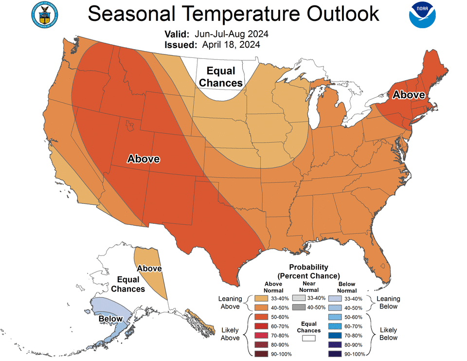
Summer heat 2024 prediction
The National Oceanic and Atmospheric Administration recently released its seasonal temperature outlook with predictions for June, July and August. That outlook shows the majority of the U.S. likely seeing above-normal temperatures this summer. At least 20 states, including Washington, Texas, Colorado and almost the entire Northeast, are most likely to experience the out-of-norm heat. Only one small section of one state, southwest Alaska, is expected to have below-normal temperatures.
La Niña can also bring more heat domes, Dance said, which are essentially high-pressure areas that "keeps it sunny."
"It can last for days," he said. "…We're certainly looking out for that sort of thing this summer."
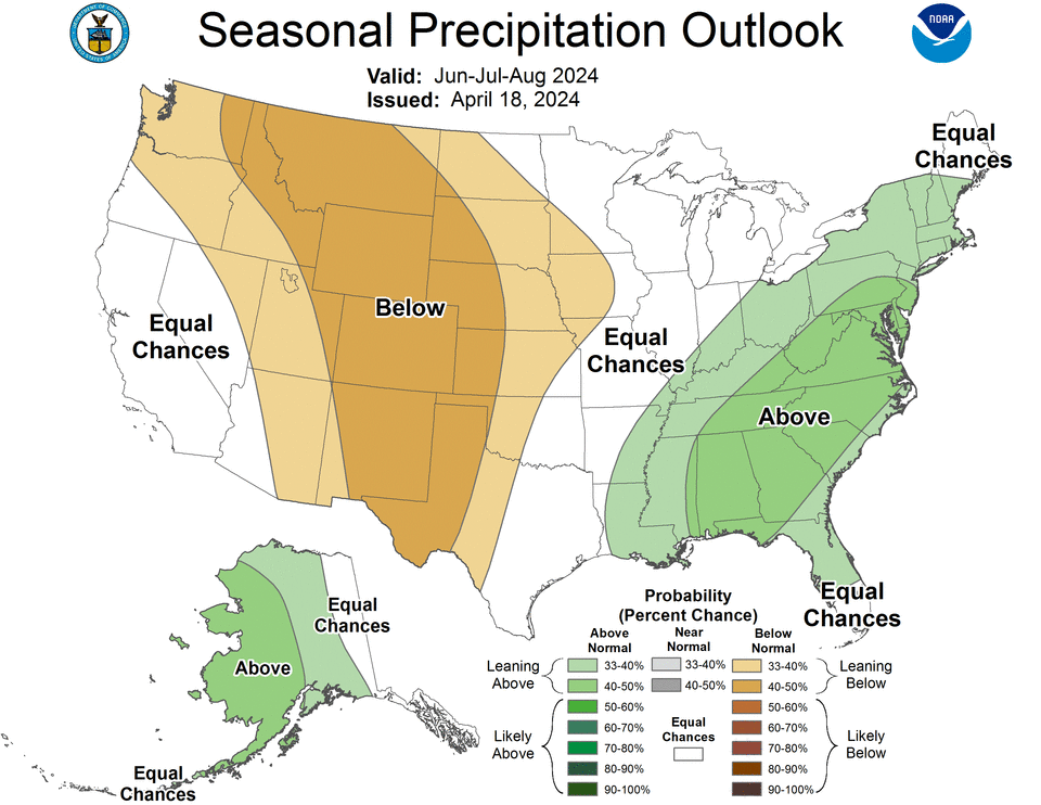
Summer rain 2024 prediction
There will also be a wide range in precipitation, with the western U.S. expected to see below-normal rain while the majority of the east coast and Alaska are expected to see above-normal rainfall. The U.S. seasonal drought outlook shows that many areas where below-normal precipitation is expected are also expected to develop or have persisting drought conditions.
Officials brace for extreme heat in the U.S.
The U.S. Department of Health and Human Services is also warning of the expected temperatures, which even in winter, started popping up across the U.S. On Monday, Philadelphia hit 90 degrees Fahrenheit – marking the first time the city has seen that high of heat in April in 15 years. Last year was also the hottest one ever recorded, with January, February and March all seeing record temperatures.
Based on one model, the department says temperatures are expected to be between 1 and 2 degrees Fahrenheit hotter than average "across almost all of the contiguous United States." Some areas, however, including the Great Plains, the Midwest, southeastern New Mexico and western Texas could see even worse scorchers. Based on the model, the HHS said the 90-day average could be between 1.8 and 3.6 degrees Fahrenheit above normal for the time frame.
If the trend of record-breaking heat continues, this summer could not only be extremely hot – but extremely dangerous.
The forecast comes days after NOAA expanded its heat risk tracking website, called HeatRisk, which is meant to help provide information to vulnerable populations during extreme heat events. Some demographics, including the elderly, children and individuals with some chronic respiratory and heart conditions, are more susceptible to heat-related illnesses that could prove fatal – and extreme heat is only expected to worsen in the coming years.
"Climate change is causing more frequent and intense heat waves that are longer in duration, resulting in nearly 1,220 deaths each year in the U.S. alone," NOAA Administrator Rick Spinrad said. "Last year was the warmest year on record for the globe, and we just experienced the warmest winter on record. HeatRisk is arriving just in time to help everyone, including heat-sensitive populations, prepare and plan for the dangers of extreme heat."
Stormy Daniels' lawyer testifies in Trump trial
Inside America's child care crisis as parents, providers sound alarm
Black male voters in Georgia on why they're backing Republicans

