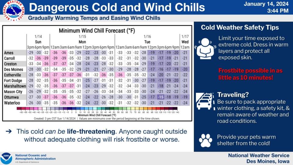
What were the lows around Iowa as arctic cold settles over the state?
While the last of blizzard conditions are expected to end Saturday night in Iowa, what's expected to be one of the longest periods of sub-zero temperatures in decades is setting in, with life-threatening wind chill.
Here are the latest updates.
5:15 p.m. Some actual good news about the weather
The National Weather Service included a long list of bad news/good news in its latest forecast guidance on Sunday. It acknowledged that little of it, such as a Wednesday "warm up" that can only be described as such because the temperatures will finally rise somewhat above zero, was arguably all that good. But there was one undeniably positive nugget at the end of the list: Late in the weekend of Jan. 20 and 21, the weather appears likely to take a turn for the better.
"There is a consistent signal for a pattern change arriving around next Sunday and Monday, Jan 21-22 that may result in much warmer temperatures," it said.
The guidance added that it's too early for a forecast of just how much higher temperatures will go.
"That is in the day 7-8 time range and not all included in this forecast," it said. "Until then, stay warm!"
3:20 p.m. Return to normal will be slow on Iowa roads, IDOT says
The Iowa Department of Transportation in a Facebook posting says condition on the state's roads have improved since Saturday, when sections of Interstate 80 and other highways around the state were impassable because of ice and blowing snow. But there are still trouble spots.
"We'll be using snow blowers to move the snow further back away from the road, but this is a slow process," IDOT said, adding "It could take up to a week to get the mess cleaned up because ditches are full and high winds will continue to cause drifting snow."
It cautioned motorist to slow down, use extra caution and pay attention to what's on the road ahead.
2:15 p.m. Where was it coldest overnight?
The National Weather Service says the lowest temperature it recorded before dawn Sunday was in Pocahontas in northwest Iowa, with a reading of 21 degrees below zero. Here are other lows from around the state on a day when the high in Des Moines is slated to reach just minus 9 degrees:
Ames -17
Boone -20
Cedar Rapids -18
Council Bluffs -17
Davenport -15
Des Moines -17
Dubuque -15
Fort Dodge -18
Iowa City -16
Mason City -15
Ottumwa -20
Waterloo -14
Wind chills ranged as low as 45 degrees below zero.
1:30 p.m. Authorities clear path through storm for mom in labor
From the Marshall County Sheriff's Office comes an account of how deputies and other first responders worked in blizzard conditions to ensure a woman in labor got the care she and her baby needed.
A news release from the sheriff's office said the call for help came at 11:20 p.m. Saturday, while a blizzard warning remained in effect, and deputies were dispatched to the woman's home. Unable to reach her home because of road conditions, they hiked a half mile to reach her as Marshall County communications center personnel remained in contact with her, it said.
The Clemons Fire Department, meanwhile, was able to secure a tractor to clear a path so a Unity Point ambulance could reach the home, the release said. It said the woman gave birth at 12:38 a.m. and she and the baby were taken to the hospital.
8:30 a.m. A very low high in Iowa
The overnight temperature at Des Moines International Airport on Saturday into Sunday, minus 17 degrees, didn't set a record, but the forecast daytime high today could match the one for a Jan. 14: 9 degrees below zero, last seen in 1888, 136 years ago, Allan Curtis, a meteorologist at the National Weather Service in Johnston, said Sunday morning. With gusty winds, the wind chill could hover around minus 40.
And even the low is impressive, if not record-breaking: It's the lowest temperature recorded for a Jan. 14 in Des Moines since 1901 ― 123 years ago ― and tied for second place after a reading of minus 19 in 1888.. It's also the lowest for a January day, or any winter day, since a minus 20 reading in January 2019 ― five years. Wind chill, a more modern statistic, bottomed out at minus 43 degrees just before midnight.
Brace for more. The overnight low for Sunday into Monday is forecast to be only slight less low, at minus 17, with a high on Monday, Iowa Caucuses day and the Martin Luther King Jr. holiday, of minus 5 degrees. The temperature is expected to fall to minus 11 degrees Monday night, with a wind chill of minus 30.
The low temperature isn't expected to return to positive territory until Wednesday, when it will be 5 degrees.
"That'll feel awfully warm and balmy by that point," said Curtis.
Another wave of sub-zeros lows is forecast to arrive Thursday and Friday, at minus 3 and minus 12, respectively.
Want some good weather news? At least the blizzard warning is gone in Iowa. It expired at midnight for the 17 counties in which it remained in effect.
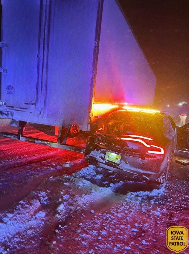
10:05 p.m. Another reel of weather photos from the Iowa State Patrol
Here's yet another Facebook collection of shots from Iowa State Patrol troopers patrolling the state's icy roads in a historic winter storm.
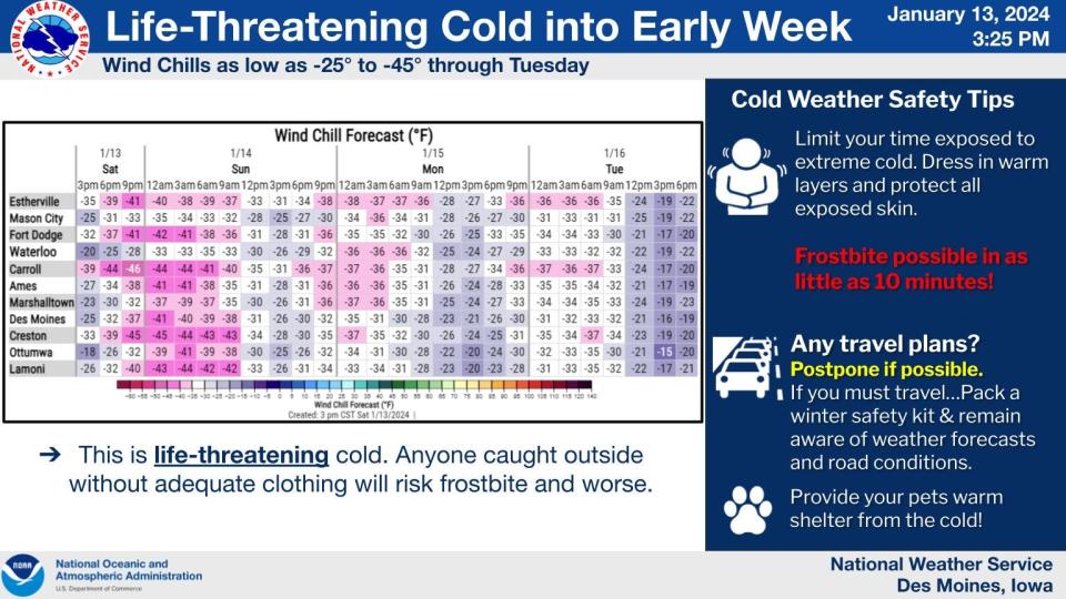
10 p.m. Saturday overnight could be worst of cold snap
The latest National Weather Service forecast has dropped tonight's overnight low to 18 degrees below zero ― the lowest expected in a period of frigid arctic air that's not expected to produce a low temperature above zero until Wednesday, and then only barely. The low and accompanying wind chill of 45 degrees below zero ― yes, you read that right ― is expected around 3 a.m.
This is the kind of weather when pipes can freeze and burst. If you haven't already taken precautions, here are some things you can do:
Leave faucets slowly dripping to keep water flowing through the pipes. The water can be captured in a bucket and used for other purposes around the home, like watering plants and washing dishes.
Open under-sink cabinets to allow warm air to circulate near your pipes.
What if there’s no water coming out of your faucets? Check your water meter. If water is leaking or spraying from your meter or the bottom is cracked, your water meter is frozen. Feel for frozen pipes. Pipes located along exterior walls are most susceptible to freezing. To thaw pipes, contact a licensed plumber or use hot towels or a hair dryer. Never use an open flame.
Also, if you can, get your car into a garage or at least under a carport. Extreme cold is murder on the battery. Even a few degrees can make a difference.
And above all, stay inside if you can. Even if tonight is the coldest, it won't be much warmer Sunday or Monday nights.
7:30 p.m. Another speeder on slippery roads
For the second time in a matter of hours, the Iowa State Patrol reported that a trooper had stopped a vehicle traveling at more than 90 mph on roads so slick with snow and ice that travel was not advised. In a posting on Facebook, it said the SUV, clocked at 94 mph, was stopped on Interstate 80 near Council Bluffs on Saturday morning. The other car, traveling at 92 mph, had been stopped Friday in northwest Iowa.
"Most people would say that 94 MPH is unbelievable during a blizzard," the state patrol commented. "Unfortunately, these speeds are still happening..."
7 p.m. Blizzard warning extended to midnight
The planned 6 p.m. conclusion for a National Weather Service blizzard warning came and went, but the blizzard conditions didn't.
The weather service instead chose to continue the warning for 17 Iowa counties until midnight. It said up to an inch of additional snow is expected in the affected area along and north of Highway 30, mainly in the state's northwest but also including Story and Boone counties in central Iowa. Winds will continue to gust up to 40 mph, above the 35 mph threshold for blizzard conditions, and visibility will fall to a quarter mile or less, another blizzard criterion.
The winds are expected to abate somewhat after midnight, the weather service said, and the focus is turning to the extreme cold building over the state. It said in forecast guidance that the temperature at its Johnston office was zero just before noon Saturday and fell to 5 below by 2 p.m. Maurice in far northwest Iowa reported a temperature of minus 15 and if certain conditions align, the Nishnabotna River valley in western Iowa also could see temperatures plummet, it said.
The wind chill warning blanketing all but the northeasternmost portion of Iowa will remain in effect until noon Tuesday, with the forecast calling for lows of minus 16 both Saturday and Sunday nights in Des Moines and minus 11 on Monday, Caucus Day and the Martin Luther King Jr. holiday. The high that day is expected to be minus 3, and only on Wednesday night will the forecast low creep back above zero, at 3 degrees.
Throughout, wind chills will be life threateningly low: 40 below on Saturday and Sunday nights and 35 below on Monday night.
Another round of deep subzero temperatures is expected to begin Friday.
6:10 p.m. Despite historic storm, crime goes on in Des Moines, keeping police busy
Des Moines police said they have received more than 778 calls for service since Friday morning during the blizzard. But three-quarters of them weren't for what you'd expect: weather-related crashes and stalled vehicles.
Instead, police spokesman Sgt. Paul Parizek said in a Facebook posting, the calls involved the sorts of cases that officers handle whether or not there's bad weather: multiple thefts, assaults, stabbings and a shooting report.
Among them:
An alleged violent attempted theft of a car. Parizek said a motorist picked up a pedestrian who seemed to need assistance shortly after 6 a.m. Friday, and that the man, identified as Jermaine Shetworth Ware, 28, began to assault the 50-year-old in an attempt to steal the car. When Ware failed, Parizek, said he flagged down another motorist on Interstate 235 and stole that car. The Iowa State Patrol stopped the car after a brief chase north of Des Moines and arrested Ware, Parizek said. Ware remained in the Polk County Jail late Saturday.
A hit-and-run accident shortly after 1 p.m. Friday at Southeast 14th Street and Park Avenue. A patrol officer witnessed the accident but because of the weather was unable to pursue the driver, who sped away. A short time later, Parizek said, the apparently intoxicated driver was found with his vehicle stuck in a snowdrift not far from the accident scene. He said the man, 42, was charged with OWI and hit and run.
A stabbing around 2:30 p.m. in the 2300 block of Dean Ave. The victim was taken to a hospital in serious condition was expected to survive, Parizek said. A suspect was identified and the investigation continues.
A report of gunshots just after 10 p.m. Friday in the 6100 block of Winona Ave. Officers called to the scene found evidence of gunfire, Parizek said, but no one apparently had been wounded. He said detectives continue to investigate.
6 p.m. Johnson County requests no travel until noon Sunday
Citing continued poor travel conditions, despite the lifting of a blizzard warning, Johnson County officials are asking resident and visitors to stay put and remain off roads until noon Sunday.
"Road conditions remain poor and light snow and blowing snow is expected to reduce visibility and road conditions in the overnight hours," they said in a news release. "Whiteout conditions and significant blowing and drifting snow is occurring in open areas and this will create dangerous conditions. These coupled with the danger(ous) temperature and wind chill are not safe for anyone to be outdoors."
They cited not only the risk to stranded motorists, but to the law enforcement and emergency services dispatched to rescue them.
"There will be enough emergencies in these conditions, please stay home to reduce the potential to create more," they said.
Motorists are encouraged to utilize the Iowa DOT 511 site, https://511ia.org
to evaluate road conditions. If you have an emergency and must travel, please dress appropriately and prepare your vehicle with first aid and winter travel supplies.
The priority message from the Johnson County Emergency Management –
Do your part; stay home, stay safe, and help keep Emergency Services off the roads.
3:40 p.m. West Des Moines extends parking ban
The city of West Des Moines has extended its emergency parking ban until 5 p.m. Sunday.
The ban, which began on Thursday at 10 p.m., applies to all streets in West Des Moines. Parking while under the ban could result in a $50 fine and towing.
3:25 p.m. Des Moines metro out of blizzard warning
The National Weather Service has lifted the blizzard warning for the Des Moines metro, reducing it to 17 counties, including Story and Boone, through 6 p.m. Most are in northwest Iowa.
The lifting of the warning, which had been in effect since Friday, came as wind gusts dropped below the 35 mph threshold for blizzard conditions. But roads remain extremely hazardous, with slippery conditions, occasional whiteouts and plenty of accidents. And the forecast calls for unfavorable conditions to continue, with gusting winds through at least Monday night.
1:45 p.m. I-80 finally passable
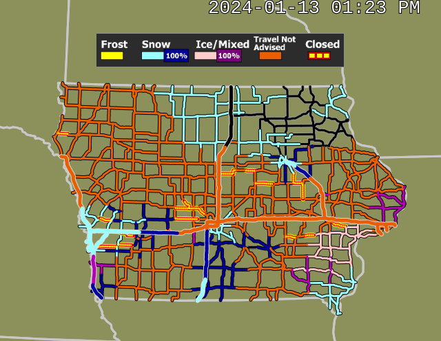
Impassable since Friday evening, the stretch of Interstate 80 from Victor in Iowa County to Tiffin in Johnson County is now more-or-less drivable, the Iowa 511 road conditions site reports. But the Iowa State Patrol and other police agencies, including Des Moines police, continue to advise against any unnecessary travel. And numerous other parts of Iowa's road system, including a stretch of I-80 from Stuart to west of Brayton and Interstate 35 from Highway 5 in West Des Moines to Van Wert, remain in sketchy shape, covered with snow.
Earlier, several cars were stuck for five hours in blowing snow on I-80 after semitrailers jackknifed in the slippery roadway, blocking traffic and leaving 100 vehicles trapped, according to The Associated Press. Altogether, state troopers handled 86 crashes and 535 motorist-assist calls since Friday, State Patrol Sgt. Alex Dinkla told the AP on Saturday afternoon.
1:15 p.m. Des Moines firefighters: Please lend a hand
There's nothing much more challenging than fighting a fire in the middle of heavy snow and extreme cold. So in a posting on X, formerly known as Twitter, the Des Moines Fire Department has a request for residents: If you're out shoveling and see a fire hydrant buried in a snowbank, please clear it off.
11:45 a.m. Des Moines Catholic diocese says mass not obligatory in dangerous weather
The Roman Catholic Diocese of Des Moines on its home page says parishioners are not obligated to attend weekend masses amid blizzard conditions and dangerous wind chill. Some pastors may choose not to hold mass, it said.
"While situations differ across the diocese, canceling a Mass is a legitimate option for pastors during such weather," it said. "If someone is concerned about making it to Mass on Sunday because of the weather and road conditions, know they are not obligated to do that which is unsafe."
Other churches and religious institutions also may be canceling in-person services, so check before setting out.
11:30 a.m. Grimes and Waukee have a message for drivers: Don't
Grimes and neighboring Waukee in Saturday news releases are advising residents to stay off the roads.
"The Iowa DOT is still listing roads in the metro as 'travel not advised'. Please stay home unless you have to leave for an emergency and check the latest road conditions at 511ia.org," Grimes said in its message, adding that it is extending its snow ordinance banning parking on city streets to 8 p.m. Sunday.
"Our crews are still out, but the winds are continuing to cause significant drifting," it said. "They will be able to clear more extensively tomorrow."
Waukee's message was similar.
"Blizzard conditions continue. Stay home and off the roads unless it absolutely necessary to be out," its release said. "Lots of cars are getting stuck in the snow which slows down the plows and makes roads more hazardous. Wind gusts will continue to make travel dangerous with low visibility and drifting snow."
It said a street parking ban has been extended to 5 p.m. Sunday to keep thoroughfares clear for plowing. Violators will be fined $25 and/or towed, it said.
Des Moines Public Schools announced they were canceling all Saturday activities.
10:10 a.m. Despite warnings, motorist getting stranded; speeder clocked at 92
The Iowa Department of Transportation's Iowa 511 road conditions page posts warning about roads that are impassable. Despite that, the Iowa State Patrol says, motorists continue to attempt to traverse those roads and are becoming stranded. Meanwhile, temperatures across the state are in single digits and dropping.
District 7 - Fort Dodge Trooper Ambrose shared this video from Hamilton County. These are the conditions across most of our state today. Vehicles are getting stranded on roads that are showing as “TRAVEL NOT ADVISED” or “IMPASSABLE” on 511ia.org
Posted by Iowa State Patrol on Saturday, January 13, 2024
The recklessness was even more extreme in one case: The state patrol reported stopping a driver on Interstate 35 in northern Iowa who was going 92 mph in the winter storm. "Ridiculous and unacceptable," it commented on Facebook.
8:45 a.m. Cancellations, flight delays continue at Des Moines airport
After a day of flight delays and cancellations Friday because of blizzard conditions, the flight disruptions continued early Saturday at Des Moines International Airport. The airport's online flight status page showed cancelations beginning at 6 a.m. with an American Airlines flight to Washington and a United Airlines flight to Houston.
The airport said its crews were working to keep runway clear, and urged travelers to consult their airline's website or app before leaving to catch flights.
7:30 a.m. Blizzard warning ends for much of Iowa, but continues in Polk, Story, other counties; I-80 has detour
The National Weather Service early Saturday reduced the blizzard warning that had blanketed most of Iowa, leaving it in place until 6 p.m. for 22 counties including Polk and Story.
A wind chill warning is in effect throughout the state, with a winter weather advisory for extreme northeast Iowa.
The weather service said in forecast guidance that the eastern portion of the state can expect blizzard-strength winds, with gusts above 35 mph, to "level off," and visibility to improve to 1 mile through the early afternoon, above the quarter-mile limit of blizzard conditions.
It said the other counties also will see some lessening of wind speeds, but that with another inch of snow expected, it was not enough to warrant lowering the blizzard warning.
The wind chill forecast remained unchanged: For the Des Moines metro, an early morning high of 3 degrees Saturday, falling to temperatures below zero by about 3 p.m. and bottoming out overnight around 14 below, with wind chill as low as minus 40.
Conditions are expected to be similar on Monday, Iowa Caucuses day and the Martin Luther King Jr. holiday, with a midafternoon high of minus 2 and an evening low of 14 below, accompanied by life-threatening wind chill of 30 or more below zero.
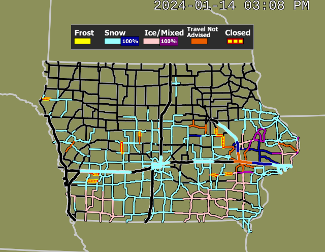
Travel remains hazardous, but the Iowa Department of Transportation reported that a portion of Interstate 80 from Victor to Tiffin, impassable because of blowing snow and accidents, could be bypassed via U.S. 6. Still, it warned on its Iowa 511 website that that route also is snow-covered, and "travel is not advised."
3 a.m. Travel remains extremely hazardous, but some improvement expected
The historic onslaught of winter weather continues across Iowa.
The Iowa 511 website shows both east- and westbound Interstate 80 remain impassable from Victor in Iowa County to Coralville in Johnson County because of blowing snow. Even with less-than-expected snowfall north and west from Audubon to Hampton, wind gusts to 45 mph and whiteouts are expected to continue to make travel throughout most of Iowa hazardous throughout the day Saturday.
As of 10 p.m. Friday, the Iowa State Patrol said on its Facebook page it had provided 436 motorist assists and responded to responded to 72 crashes, including one in which a trooper's cruiser was damaged by a semi unable to stop on I-80 near Williamsburg because of icy conditions. The trooper was uninjured.
The National Weather Service office in Johnston says blizzard conditions are expected to abate later Saturday morning in east and northeast Iowa, where the blizzard warning will be lowered to a winter weather advisory. But it said that from I-35 west and I-80 north, the warning will continue, and travel should be restricted to emergencies only.
The chief hazard will gradually shift to life-threatening cold. The temperature is forecast to fall continually over the next 24 hours, hitting a low of minus 14 degrees in Des Moines early Sunday, with a windchill of nearly 45 degrees below zero. Sunday's high is expected to be minus 6 degrees. Another inch-plus of snowfall is expected, adding to what already is projected to be the second-greatest accumulation in a five-day period recorded in the state.
"The period of extreme, life threatening wind chill will continue Sunday night into Monday with late morning and afternoon wind chills rising to the 20 to 30 below, only to fall to 30 to 35 below Monday evening," the weather service said in 3 a.m. forecast guidance, adding, "Our only day of respite from the cold will be Wednesday as a weak wave tracks southeast from the Northern Plains."
7:35 p.m. Road conditions deteriorate across Iowa; I-80 impassable
Conditions on Iowa roadways deteriorated dramatically as the blizzard intensified across the state.
Interstate 80 west of the I-80/Interstate 380 interchange near Victor was impassable in both directions due to drifting snow, icy conditions and crashed vehicles, according to the Iowa Department of Transportation.
The DOT in a news release traffic should avoid that section of Iowa's main east-west highway until conditions improve.
Surrounding roadways like I-380 and U.S. 218 also were experiencing significant amounts of drifting snow, which the DOT said may make them "difficult or impossible to travel on as the night progresses."
The Iowa 511 traffic conditions page also reported numerous other Iowa roadways as blocked or impassable because of accidents and drifting snow and recommended against travel on I-80 and Interstates 235 and 35 in Des Moines, as well as much of U.S. 65.
Several counties, including Johnston and Story, and cities, including Urbadale and Altoona, suspended snowplowing, say high winds and drifting snow made the work too hazardous to continue.
6:45 p.m. Storm close to record
The National Weather Service says the snowstorm that began Thursday and the one that preceded it this week have dumped snow at a nearly record-setting pace.
Meteorologist Chad Hahn at the weather service's Johnston office said Friday night that by the end of the current snowstorm, an estimated 21.3 inches of snow that will have fallen in the past five days.
That would about an inch-and-a-half shy of the all-time record for Iowa and ahead of the second-place snowfall, making it the most five-day snowfall in 82 years.
The current top five-day snowfalls are:
22.7 inches from Dec. 28, 1941, to Jan. 1, 1942.
20.2 inches from March 14-18, 1923.
17.7 inches from Dec. 5-9, 2009
5:18 p.m. Latest snowfall totals
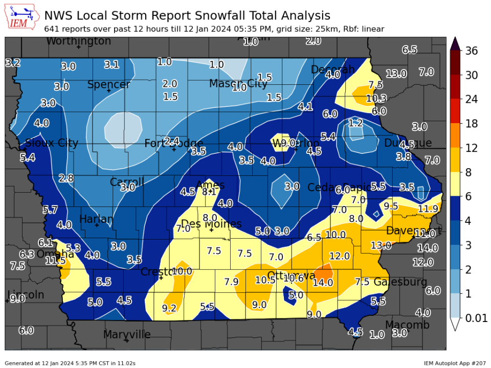
The National Weather Service says 8 inches of snow had fallen in Des Moines by 5 p.m. in the latest storm, on top of 11.2 inches that fell in the previous winter storm that concluded Tuesday. Other totals include 8 to 10 inches in the Iowa City area, 10.5 inches in Osceola, 11 inches in Davenport, 11.5 inches in Council Bluffs, about 12 inches around Washington and Clinton, 13 inches in Muscatine, and, tops for the state, 14 inches around Fairfield. Snow is expected to continue for several hours.
5 p.m. Urbandale suspending snow plow operations
Snow plowing operations in Urbandale will be suspended starting at 7 p.m. Friday due to sustained high winds and significant drifting, according to a news release from the city.
Plowing is expected to resume at 5 a.m. Saturday, when it is anticipated that wind conditions will be better suited for plowing.
3:45 p.m. Wind chills not expected to reach positive numbers again until Wednesday
Bundle up and stay indoors! The wind chill at 3:45 p.m. Friday had dipped to minus 4 and it's only going to go lower.
Wind chills are expected to dip into the negative 20s on Friday night and could reach as low as minus 45 degrees over the weekend.
Des Moines won't see a wind chill index above 0 until Wednesday, said NWS meteorologist Alexis Jimenez.
4:30 p.m. Des Moines Public Schools cancels Saturday activities
All events at or involving Des Moines Public Schools are canceled Saturday, due to weather conditions.
3 p.m.: Iowa State Patrol responds to dozens of crashes, helps hundreds of motorists
Despite pleas for Iowans to stay off the road, the Iowa State Patrol has been called to help hundreds of Iowans in the blizzard on Friday.
Troopers have been dispatched to 34 crashes, including seven with injuries between 12:30 a.m. and 1:30 p.m. on Friday. They've also been called for 355 motorist assists.
3:15 p.m.: Travel not advised in more than half of Iowa
If you're planning to travel anywhere east of Des Moines, you're likely to encounter difficult conditions and dangerous roads.
Travel is not on most highways east of I-35 in central and southern Iowa. Most highways in the southern third of the state are also rated travel not advised. All highways in the state are at least partially covered by snow and ice, according to the DOT.
Visibility in most of Iowa was less than a mile at times. In central Iowa visibility ranged between 0.8 mile to 0.5 mile because of blowing snow, according to the Iowa Environmental Mesonet.
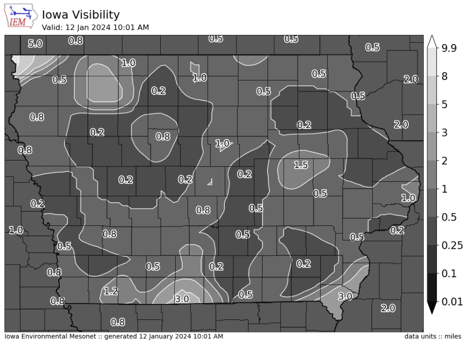
"As expected, road conditions are going downhill fast this morning with heavy snow and strong winds decreasing visibility and causing drifting on some Iowa roads," the Iowa DOT wrote on social media.
(1-12 10:45 a.m.) Conditions are very poor in most of Eastern Iowa this morning and getting worse. Our crews are out, but the snow is blowing back on the roads about as quickly as we get a plow through. Visibility is very low. If you must drive SLOW DOWN!! #IAWX pic.twitter.com/pgh2Qpomlj
— Iowa DOT (@iowadot) January 12, 2024
The DOT has more than 600 snowplows treating roads throughout the state, but high winds and snows are making travel conditions treacherous, according to Iowa 511. In rural areas snow is drifting across roads quickly after plows clear roads.
More: How to check Iowa road conditions, DOT cameras amid winter storms
3:30 p.m.: Some flights are finally arriving at Des Moines airport
Few flights got in and out of the Des Moines International Airport on Friday, but a handful were able to land by early afternoon.
A single commercial flight landed Friday morning — a Frontier flight from Orlando. But, two American Airlines flights and one United flight were able to land as of 2 p.m. and two flights from New York were in the air toward Des Moines as of 3:30 p.m.
As of 3:30 p.m., 69 flights scheduled to go into or leave from the Des Moines International Airport were canceled, according to FlightAware.com. Six other flights were delayed.
That represents 59% of flights originally scheduled to take off from the airport on Friday and 53% of inbound flights.
At least 10 commercial flights have taken off Friday.
Flights across the Midwest were delayed by Friday's storm. At Chicago O'Hare Airport hundreds of flights were delayed or canceled, according to Flight Aware. The Eastern Iowa Airport in Cedar Rapids also experienced numerous cancelations Friday morning.
12:30 p.m.: HHS cancels MLK Day event
Iowa HHS has canceled its Martin Luther King Junior celebration scheduled for Saturday, Jan. 13, due to the weather conditions. The capitol building will also be closed.
Questions can be directed to Kim Cheeks, Office on the Status of African-Americans, at kim.cheeks@iowa.gov, or 515-281-3274 or 800-351-4659.
11 a.m.: MidAmerican Energy crews work to prevent power outages
MidAmerican line crews have been surveying overhead lines in areas that were impacted on by storms earlier this week to reduce threats from tree debris and address any equipment concerns, according to an update Friday morning. MidAmerican's electric and gas delivery teams are fully staffed should any outages occur.
A main concern for MidAmerican is the wind as the storm transitions into blizzard conditions. High winds can cause overhead lines with a freezing precipitation buildup to bounce — known as galloping — which can interrupt service.
Noon: How much snow did Iowa get?
Snow has started to wind down in central Iowa. Reports from across the state are nearing the one-foot mark.
Des Moines (airport): 6.1 inches
Johnston (National Weather Service): 7.2 inches
Fairfield: 11.5 inches
See more: Top snowfall counts from across Iowa
What's the Iowa radar show and what should we expect throughout the day on Friday?

Weather
Embedded content: https://radar.weather.gov/ridge/standard/KDMX_loop.gif
The morning will start with periods of heavy snow, continuing until about 10 a.m. for central Iowa. An additional 3-5 inches of snow is possible by the end of the day. Snowfall rates of about .75 inch to one inch per hour are possible throughout the morning, according to the NWS.
But the weather service warned that blizzard conditions will make travel dangerous or impossible. A blizzard warning will be in effect from 10 a.m. Friday to 6 a.m. Saturday for central Iowa as wind speeds pick up and reduce visibility. Winds could gust as high as 45 mph and wind speeds between 35 and 45 mph are likely.
Temperatures are expected to plunge throughout the day to 13 degrees by 5 p.m. Wind chills could feel as low as -10 degrees, according to the NWS, adding to the danger for motorists stuck outside.
Snow is expected to taper off over central Iowa tonight. But even after snow stops falling it will continue blowing and make travel difficult. "Blowing snow impacts will linger well beyond the end of falling snow, especially in rural and open areas," the NWS in Des Moines warned in its 6 a.m. update.
Blizzard forces GOP presidential candidates to cancel events Friday
Nikki Haley's campaign has canceled three in-person events scheduled Friday in Fort Dodge, Le Mars and Council Bluffs due to the weather.
Instead, campaign officials said they would be hosting telephone town halls.
“Stormy weather won’t stop us from ensuring Iowans hear Nikki’s vision for a strong and proud America,” Pat Garrett, a Haley spokesperson, said in a statement. “With only three days until the caucuses, we’re going to keep telling voters why they should Pick Nikki.”
Read more: Blizzard warning forces GOP candidates to cancel some Friday events days before Iowa Caucuses
Ron DeSantis also canceled two events Friday morning.
However, candidate Vivek Ramaswamy said he would continue on with every event as "long as we can physically make it." His campaign went into a ditch earlier this week and needed the help of a passerby to get out.
In 2016, a volunteer for Ben Carson's campaign died when a campaign vehicle lost control on an icy Interstate 80 and crossed the median.
Traveling on Interstates 35 or 80 and need to escape the blizzard? These are safe places to park.
With difficult travel conditions likely, Polk County has designated the following locations as safe places for interstate travelers to pull over and wait out blizzard conditions.
Prairie Meadows: 1 Prairie Meadows Drive, Altoona
Flying J Travel Plaza: 3231 Adventureland Drive, Altoona
Pilot Travel Center: 11957 Douglas Parkway, Urbandale
Love's Travel Stop: 11820 Hickman Road, Clive
After warm December, winter arrives with a vengeance
Iowa had the warmest December on record, dating back to 1895. On Dec. 24, Des Moines had a high temperature of 58 degrees, 15 degrees above average. Now, within about a week in January the NWS has issued almost every type of winter weather watch or warning, except for an ice storm warning. In the last week the NWS has issued a blizzard warning, winter storm warnings, winter storm watches, winter weather advisories, wind chill warnings, wind chill watches and wind chill advisories.
On Wednesday night the weather service even issued a rare snow squall warning when a snow squall hit the Des Moines Metro area. The snow Friday will make travel conditions dangerous, but sub-zero temperatures will settle in through at least Tuesday, according to the NWS. Arctic air will spill into the Midwest, and could lead to record low temperatures of negative 20 degrees or negative 30 degrees, according to an NWS forecast.
Des Moines Public Schools, others cancel classes for Friday ahead of blizzard; Some city buildings close.
Des Moines Public Schools announced Thursday afternoon that classes will be canceled for Friday due to the forecast. All activities are canceled, and Metro Kids Care is closed. All offices will be closed.
Other large metro school districts including Johnston, Southeast Polk and Waukee have also canceled Friday classes. Urbandale had a previously scheduled professional work day without classes on Friday. Staff will work remote and child care will not be available.
Story County offices and buildings will be closed on Friday because of the snow. Grimes also announced its buildings were closed.
NWS issues blizzard warning for most of Iowa on Friday
A blizzard warning will be in effect from 10 a.m. Friday until 6 a.m. Saturday in northwest and central Iowa, according to the National Weather Service. In eastern Iowa, a blizzard warning starts at 5 p.m. Friday and extends until noon on Saturday.
Wind gusts as high as 40 mph are expected Friday afternoon and night, which will blow around snow and reduce visibility. Travel is expected to be very difficult, and is recommended to be avoided if possible.
What's the difference between a blizzard warning and a winter storm warning?
Blizzard warnings are issued for frequent gusts greater than or equal to 35 mph accompanied by falling and/or blowing snow, according to NWS. Blizzards frequently reduce visibility to less than 1/4 mile for three hours or more.
A blizzard warning means severe winter weather conditions are expected — as in the case right now — or already occurring. Falling and blowing snow with strong winds and poor visibilities are likely, leading to whiteout conditions making travel extremely difficult.
NWS recommends Iowans not travel during a blizzard warning. If you must travel, have a winter survival kit with you. If you get stranded, stay with your vehicle and wait for help to arrive.
Winter storm warnings are issued for a significant winter weather event that includes snow, ice, sleet or blowing snow or a combination of these hazards. Travel is often difficult or impossible when winter storm warnings are in effect. If a winter storm warning is in effect, you should consider delaying your travel plans until conditions improve.
Des Moines Performing Arts postpones STOMP performances
Performances by musical group STOMP, originally scheduled Jan. 12-14 at the Des Moines Civic Center, have been postponed due to “anticipated weather conditions,” according to a Thursday evening press release.
According to the release, all four performances have been rescheduled for June 21-23. All previously purchased tickets will be honored on the new dates.
Ticketholders can contact the Ticket Office at 515-246-2300 or info@dmpa.org.
When is snow supposed to start in Iowa and what does the forecast show?
Snowfall will begin over western Iowa late Thursday afternoon, according to National Weather Service's Des Moines office.
On Thursday, there's a 70% chance of snow in Ames at 6 p.m., an 85% chance in Carroll at 6 p.m. and a 75% chance in Des Moines at 6 p.m.
Heaviest snowfall rates will be early Friday morning through mid-day. There is also a chance of freezing rain in the morning on Friday.
How much snow will Iowa get?
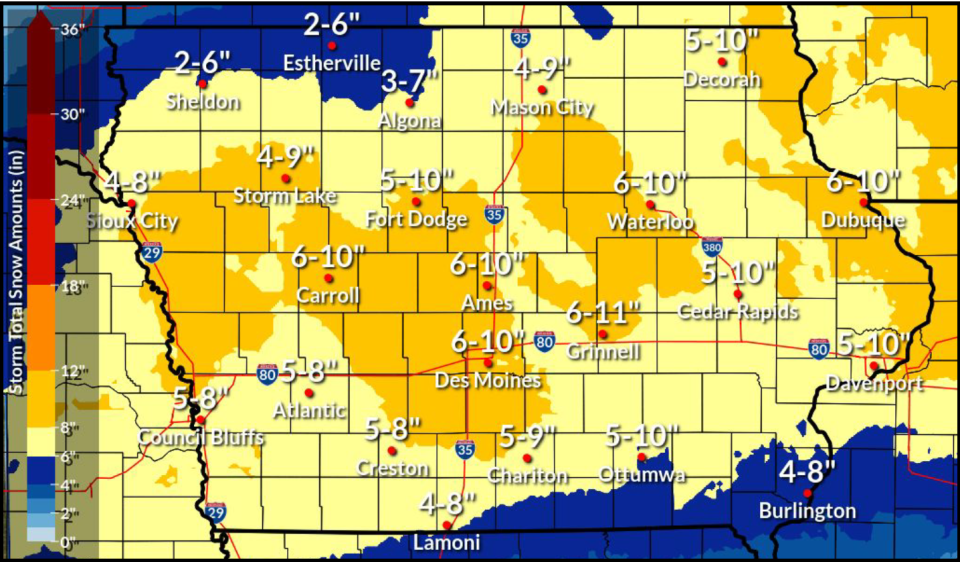
The NWS says significant snow will come to most of the state. Snow could fall at as much as an inch an hour during the overnight hours on Thursday. Wind gusts of 35-45 miles per hour will create "near-blizzard" conditions and could create whiteout conditions.
Most of the state is looking at 5-10 inches of snowfall with the heaviest areas landing around Des Moines, Ames and Carroll. Heavier pockets are also possible around Waterloo and Dubuque.
Des Moines has gotten a lot of snow this week. Will it set another record?
Maybe! The official total at the Des Moines International Airport from the first snowstorm this week was 11.2 inches.
The current 5-day record in Des Moines is 22.7 inches (Dec. 28, 1941 - Jan. 1, 1942), according to a post from the NWS. If Des Moines gets 10 more inches, we won't break that record. But, we could break the second-place record of 20.2 inches (March 14-18, 1923).
DART expects bus service delays as snow approaches
Winter weather will likely delay metro bus services Thursday evening through Saturday, and especially on Friday, according to a news release from the Des Moines Area Regional Transit Authority.
Those using DART Paratransit, On Demand, or Flex Connect services, should prepare for ride delays depending on the amount of snowfall and blizzard-like conditions, DART officials said. DART officials will not be able to pick up or drop off passengers in parking lots that have not been plowed.
Here are the possible service delays depending on the amount of snowfall, according to DART:
2 to 3 inches of snow: Pick-up times could be delayed by 30 to 60 minutes.
3 to 5 inches: Pick-up times could be delayed by 60 minutes or more.
5 to 8 inches: Pick-up times could be significantly delayed by more than 60 minutes. Customers with non-critical trips are asked to reschedule trips for another day.
Buses running more than 20 minutes late will be posted on DART's website.
How cold will temperatures get in Iowa?
The winter storm will also be accompanied by bitter cold temperatures.
Highs across the state will be in the teens to mid-20s on Thursday and will drop into the single digits by Saturday.
Wind gusts will be in the 30-40 miles per hour range through the weekend. Wind chills will reach their lowest levels on Sunday with ranges in the -20 to -45 range across the state.
Are snow ordinances and parking bans in place in central Iowa?
Parking restrictions automatically kick in for most cities in central Iowa once 2 inches of snow have fallen. Often cities will activate restrictions in advance of major snowstorms.
More: Des Moines snow parking rules: Where and when it's safe, and where you could be ticketed
Here are the metro cities that have announced restrictions ahead of this winter storm:
Altoona: The snow removal parking ban is in effect in Altoona beginning at 5 p.m. on Thursday, Jan. 11 through 5 p.m. on Saturday, Jan. 13 or until all city roadways are cleared.
Ames: A snow ban will start at 10 p.m. Thursday for all snow routes marked by red and white signs. The ban continues until roads are completely cleared curb to curb, likely until Saturday morning.
Ankeny: Parking is not allowed on all public streets, alleys and on-street parking within the city from 9 p.m. Thursday to 9 p.m. Saturday. Vehicles parked on the street during the snow ordinance will be ticketed $40 and may be towed. Parking is also prohibited in The District at Prairie Trail and Uptown Business District from 2-6 a.m.
Clive: Residents are asked to move their parked vehicles from city streets.
Des Moines: Snow ordinances are in place. Parking is prohibited on designated snow routes. In odd/even neighborhoods: Drake, Carpenter, River Bend and Sherman Hill. Signage will direct drivers on which side of the street to park based on the day of the week, between 7 a.m. and 7 p.m.
Indianola: Prohibits parking on any public street or alley, this ordinance remains in effect for 48 hours after the snow has stopped falling or until the streets are clear.
Johnston: The City of Johnston has declared a snow ordinance effective Thursday at 6 p.m. until Friday, Jan. 12 at 5p.m. During this time, no parking is allowed on city streets. If residents park on a city street, they could receive a ticket.
Waukee: A parking ban will start at 7 p.m. Thursday and continue until 5 p.m. Saturday. Cars left on city streets are subject to $25 fines and/or towing.
West Des Moines: An emergency parking ban for snow removal goes into effect Thursday at 10 p.m. and has been extended until 5 p.m. on Saturday. The parking ban applies to all streets in West Des Moines, and cars are subject to a $50 fine and/or towing.
Des Moines Register reporters Virginia Barreda and Stephen Gruber-Miller contributed to this report.
This article originally appeared on Des Moines Register: Blizzard hits Iowa with snow, gusty winds; extreme cold expected

