Cincinnati weather: Freezing rain, light snow possible this week; river levels on the rise
When will it snow again in Greater Cincinnati?
According to the National Weather Service in Wilmington, some patchy drizzle may turn into a very light snowfall in much of the area Monday morning.
A hazardous weather outlook is in effect Tuesday, stating that a mix of rain, freezing rain, snow, and some sleet may occur at daybreak through mid-morning. Shortly after noon, the wintery mix will change to all rain.
This precipitation will end in the evening from northwest to southeast, with some snow mixing in after dark, where it is still precipitating. Given the mix and rapid change to rain, little accumulation is expected, but any ice or a slushy accumulation of snow would pose a hazard to commuters during this time.
The advisory is in place for Hamilton, Clermont, Clinton, Butler, and Warren counties in Ohio and Boone, Kenton, and Campbell counties in Kentucky.
A warming trend is expected to occur on Wednesday, but a cold front will cross the region Thursday night into Friday. Only a slight chance of rain showers is in the forecast for this period.
Cloudy skies will persist into midweek. Temperatures this week will be within a few degrees of normal, with highs in the upper 30s and near 40 in the south.
Here is a broad overview for this week.
Thursday will be the warmest day.
A wintry mix will occur on Tuesday.
Clouds will remain persistent into midweek. pic.twitter.com/FupQjwz5z2— NWS Wilmington OH (@NWSILN) January 29, 2024
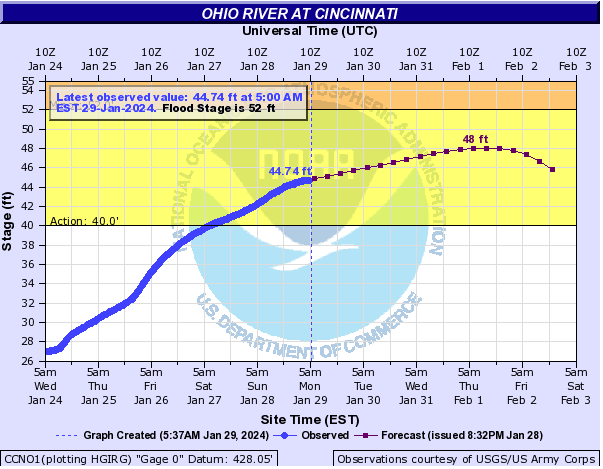
What is the Ohio River level at Cincinnati?
According to the weather service's Advanced Hydrologic Prediction Service, the Ohio River at Cincinnati was recorded at 44.74 feet as of 6 a.m. Monday morning. While that level is still below flood stage, 52 feet, it is above the "action stage" of 40 feet.
More: Ohio River level at Cincinnati is above 'action stage'. What it means
The NWS states the action stage is the river level at which agencies in the surrounding areas should start closely monitoring the river level.
This week, the river is expected to continue to rise, peaking at 48 feet around Thursday before dipping back to around 45.8 feet by Friday.
Detailed Cincinnati weather forecast
Monday: Patchy drizzle and flurries before 9 a.m. Cloudy, with a high near 41. Northwest wind around 7 mph. Mostly cloudy at night, with a low of around 30. Southwest wind 5 to 7 mph.
Tuesday: There is a chance of rain, snow, and freezing rain before noon, then rain. High near 42. South wind 8 to 10 mph. The chance of precipitation is 80%. Little to no ice or snow accumulation is expected.
There is a chance of rain at night, mainly before 7 p.m. Cloudy, with a low of around 33. Northwest wind around 5 mph. The chance of precipitation is 30%. New precipitation amounts of less than a tenth of an inch possible.
Wednesday: Mostly cloudy, with a high near 43. Northwest wind 5 to 7 mph. Partly cloudy at night, with a low of around 32.
Thursday: Mostly sunny, with a high near 51.
Friday: Partly sunny, with a high near 45.
Saturday: Sunny, with a high near 42.
Sunday: Sunny, with a high near 42.
Source: The National Weather Service in Wilmington, Ohio.
This article originally appeared on Cincinnati Enquirer: Cincinnati weather: What is the Ohio River level at? More rain coming
