How will climate change affect Wisconsin in the coming years? Here's what experts say
This probably won't surprise you if you spent any time outside over the past few months, but winter 2023-2024 was Wisconsin's warmest on record by more than two degrees.
Experts say a major reason behind this record-setting winter was a particularly strong El Niño event. El Niño is a regularly and naturally occurring weather phenomenon where sea surface temperatures in parts of the tropical Pacific Ocean warm to above average for multiple months. During a strong El Niño year, the northern United States generally experiences milder winter weather. Last year, the National Weather Service said this winter's El Niño was on track to be one of the strongest on record.
However, many climate scientists also agree that long-term climate warming trends have contributed to the wild weather we saw this winter, which ranged from Wisconsin's first-ever February tornado to a 77-degree February day.
This past winter has been declared Wisconsin’s warmest since record-keeping began in 1895. This 3-month statewide average temperature was 28.3°F, which is 9.8°F above normal (the 1991-2020 normal is 18.5°F). pic.twitter.com/JXr1aqrIcU
— Wisconsin State Climatology Office (@WI_ClimateSCO) March 8, 2024
Experts say it's difficult to determine just yet the extent to which this season's El Niño was caused by climate change, however, they'll certainly study it. Michael McPhaden, senior scientist at the National Oceanic and Atmospheric Administration's Pacific Marine Environmental Laboratory, said that human-influenced climate change may have strengthened El Niño and La Niña events since 1960.
According to data from the Wisconsin Initiative on Climate Change Impacts, or WICCI, average daily winter temperatures in Wisconsin have risen as much as 6 degrees in some areas between 1950 and 2018.
WICCI's project also includes numerous projections of how Wisconsin's climate is likely to change by the middle of the 21st century. These studies find that the state will likely become much warmer and see a "modest increase" in precipitation over the coming decades.
Here's a deeper look at what WICCI's projections could mean for the future of Wisconsin's climate.
How will Wisconsin's annual climate change by 2060?
"Wisconsin is likely to become a much warmer state over the next few decades, with average temperatures more like those currently experienced in states hundreds of miles to our south," WICCI says.
WICCI's projections compare 30-year averages from 1981-2010 to projected averages for 2041-2060.
By the middle of the 21st century, the average daily temperature in Wisconsin is expected to be 5 degrees warmer in most areas and 4 degrees warmer in some of the easternmost counties, including Brown and Milwaukee counties. Between 1950 and 2018, Wisconsin's average daily temperature rose between 2 and 5 degrees, depending on the region.
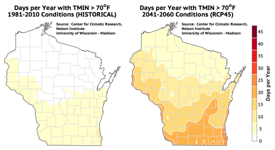
The number of days per year with minimum, or low, temps over 70 degrees is projected to increase from fewer than 5 days to between about 5 and 15 days in northern portions of the state and from between 5 and 10 days to about 20 (and 25 in the Milwaukee area) in southern portions of the state.
Additionally, most of the state experienced fewer than 20 days per year with a maximum temp of 90 degrees during the 1981-2010 period. But, in 2041-2060, all areas are projected to experience at least 20 days above 90 degrees annually, with some areas in south-central Wisconsin experiencing these sweltering temps about 40 days per year.
Nights are also projected to get warmer throughout the state. In southeastern Wisconsin, the number of nights below freezing will drop from between 120 and 140 per year in the 1981-2010 period to about 100 nights or less annually in the 2041-2060 period. In the northernmost portions of the state, these instances will drop from about 180 nights per year to between 140 and 160.
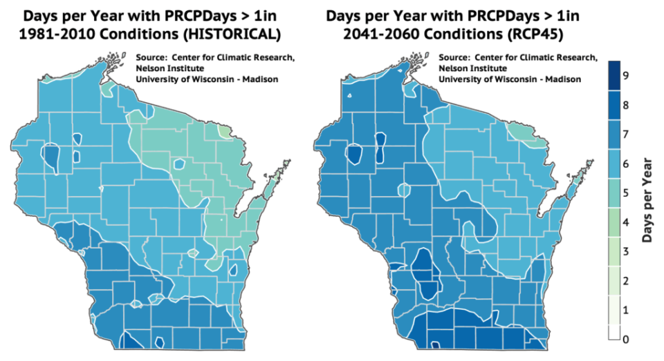
Precipitation is also expected to increase between now and the middle of the century, though less dramatically than temperature. Wisconsin will see about 5% more annual precipitation in 2041-2060 than in 1981-2010.
Between 1950 and 2018, northern Wisconsin saw about 5% more annual precipitation, while the central and eastern regions saw a 15% increase. The west, southwest and south-central regions saw 20% more.
How will Wisconsin's winter climate change by 2060?
Over the last 70 years, the average winter low temp rose between 2 and 4 degrees in the southern portion of the state and between 5 and 8 degrees in the northern and central portions. By the middle of this century, Wisconsin winters are projected to experience the greatest warming effects and the greatest increase in precipitation of any season.
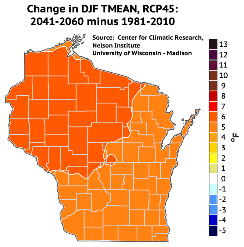
The average daily winter temperature is forecasted to rise about 6 degrees in northwestern Wisconsin and 5 degrees elsewhere. Average winter low temperatures are expected to rise even more, by 6 degrees throughout most of the state and 7 degrees in some northwestern counties.
By 2018, Wisconsin saw about 20% more winter precipitation in most areas than in 1950. By the middle of the century, most of Wisconsin is projected to see 10% more winter precipitation than in 1981-2010, though some areas in the far-southwestern portion of the state are expected to see a 5% increase.
How will Wisconsin's spring climate change by 2060?
Wisconsin's average spring daily temperatures will also increase by the middle of the century. They're expected to be 4 degrees warmer throughout most of the state and 5 degrees warmer in some northern counties.
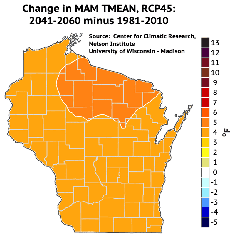
Average maximum, or high, spring temps are expected to rise 5 degrees in numerous counties in the north, central and southeastern portions of the state. Between 1950 and 2018, average daily spring temps rose 2 to 3 degrees across the state.
In the middle of the century, the entire state is projected to see 10% more spring precipitation annually than it did in the 1981-2010 period.
How will Wisconsin's summer climate change by 2060?
Summers will also get warmer and more rainy, but WICCI's maps project they'll see the least dramatic changes of Wisconsin's four seasons. Over the past 70 years, average daily summer temperatures rose 1 to 3 degrees across the state, with summer low temps rising as much as 5 degrees in some areas.
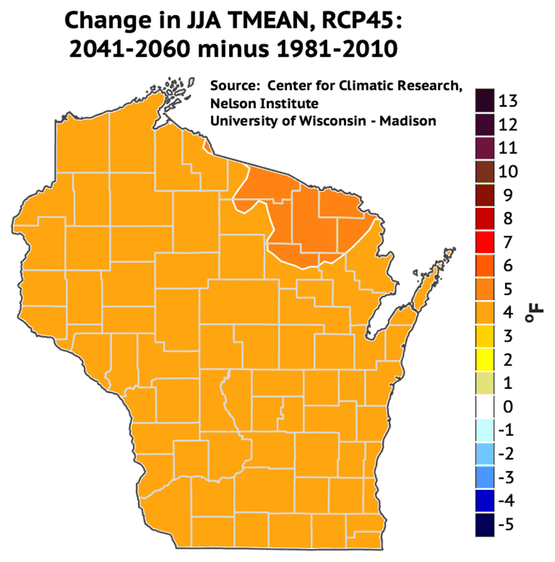
By the middle of this century, average daily summer temperatures could be 4 degrees warmer in most parts of the state. They could be 5 degrees warmer in a few northeastern counties, including Forest, Florence and Marinette. Average daily low summer temps could rise 5 degrees throughout the northeastern and north-central parts of the state and 4 degrees elsewhere.
Most of the state is expected to see less than 5% more summer precipitation annually in 2041-2060 than in 1981-2010, but some northwest and central-west counties could see a greater increase.
By 2018, southern and central Wisconsin received between 10 and 20% more summer precipitation than in 1950. However, northern Wisconsin received about 5 to 10% less.
How will Wisconsin's fall climate change by 2060?
The daily average fall temperature in most of Wisconsin is expected to be 5 degrees warmer in the middle of this century than in 1981-2010. Some areas in the far-eastern part of the state, including Door, Brown and Milwaukee counties, could see a lesser increase of 4 degrees.
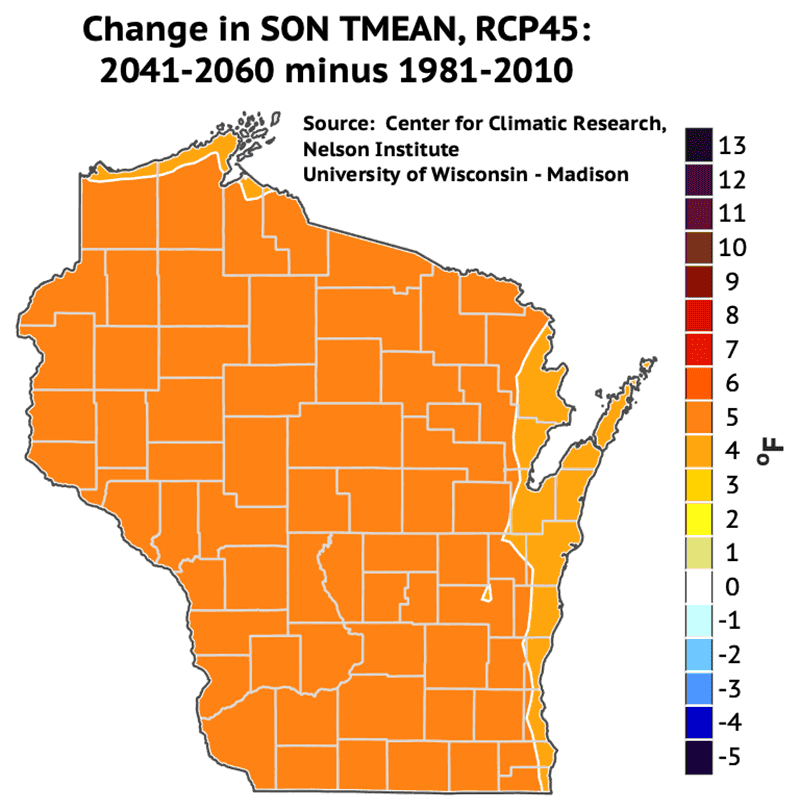
Over the past 70 years, the state's average daily fall temp has risen between 2 and 5 degrees, depending on the region. By 2018, western and northern Wisconsin received 20% more annual fall precipitation than in 1950. The rest of the state received between 10 and 15% more.
Most of the state is expected to see 5% more fall precipitation in the middle of the century than in 1981-2010. However, some parts of Douglas and Bayfield counties at the very top of the state could see 10% more, and portions of counties along the Illinois border could see less than 5% more.
Check out all of WICCI's maps here, including historical maps for the 1950-2018 period and projections for the 2041-2060 period averages.
More: A new map shows how vulnerable neighborhoods are to climate change. Here’s how Wisconsin fares
This article originally appeared on Milwaukee Journal Sentinel: How will climate change affect Wisconsin weather by the year 2060?

