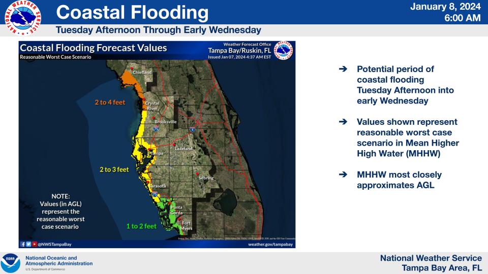
Coastal flood watch for Sarasota-Manatee; storm could bring flooding, tornadoes
The National Weather Service in Ruskin issued coastal flood and gale watches Monday for an eight-county region including Sarasota and Manatee counties in preparation for an approaching storm front that should impact the region by Tuesday.
Gale and coastal flood warning were scheduled to be in effect starting at 1 a.m. Tuesday.
A weather service alert noted that flooding could occur Tuesday morning as higher winds precede rain from the front.
Large breaking waves could result in dangerous swimming and surfing and/or local beach erosion Tuesday and Wednesday.
A "rare" storm warning was issued by the National Weather Service for Gulf waters beginning Monday afternoon for all the bays, sounds and waterways in the area, as well as the Gulf of Mexico because of the approaching front.
"This is only the second storm warning issued by us since 1994 for the Gulf waters," forecasters said.
Paul Close, a forecaster with the National Weather Service in Ruskin, said that the flooding impact could be similar to what was experienced in mid-December.
“The wind is going to start picking up late" Monday and early Tuesday, said Close, who anticipated gusts of up to 50 mph Tuesday. “It looks similar to the one we had last month.”
Forecasters posted a gale watch from late Monday until 1 a.m. Wednesday, warning of south winds of 20 to 30 knots on the Gulf and seas of 7 to 10 feet possible.
"Strong winds can cause hazardous seas which could capsize or damage vessels and reduce visibility," the alert said.
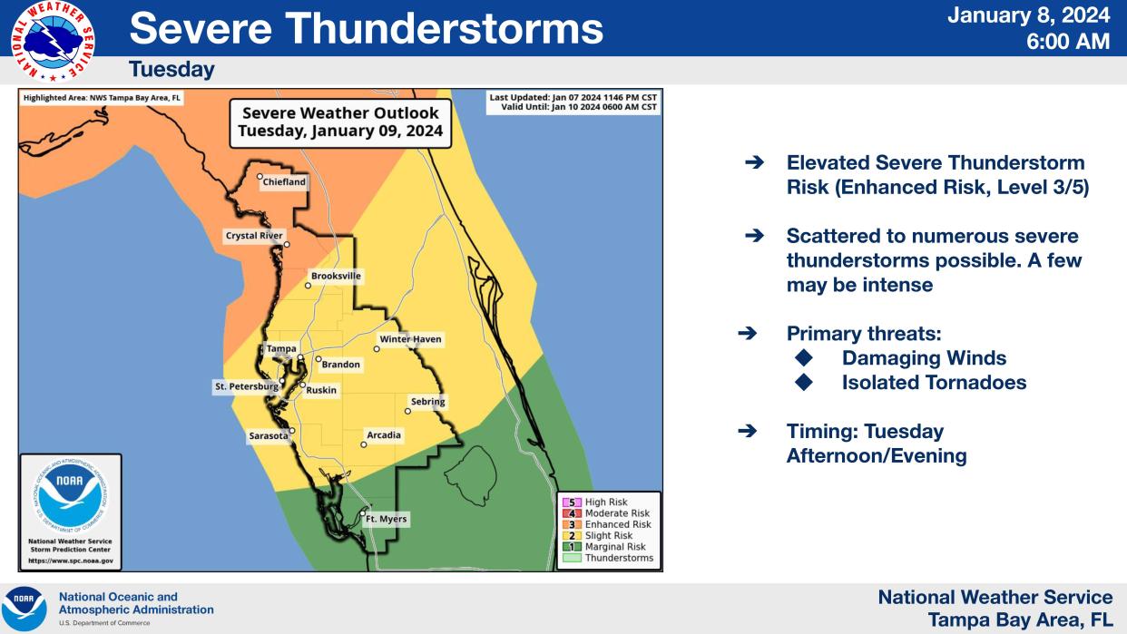
This front also has a greater potential to produce tornadoes than last Saturday's storm front, which produced an EF-0 tornado in Fort Lauderdale.
What to expect Tuesday morning
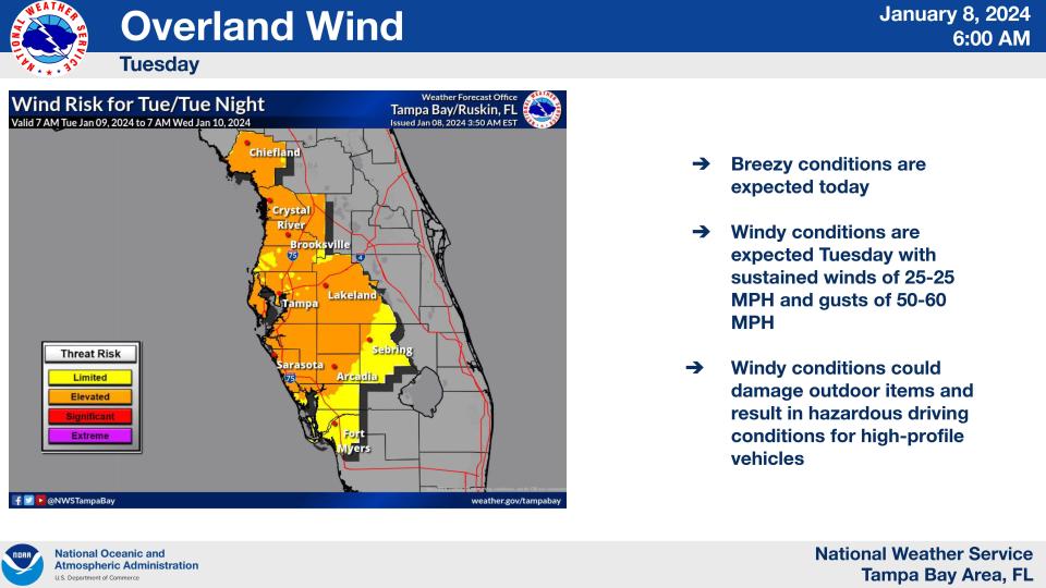
Elevated wind conditions – ranking 2 on a 5-level scale – are expected with sustained winds in the 25 mph range, with gusts between 50 and 60 mph. The weather service noted that those conditions could damage outdoor items and result in hazardous driving for high-profile vehicles.
“It’s going to be windy and warmer for most of the day,” Close said. “There will be some rain. The actual line of storms doesn’t look like it’s going to arrive until late afternoon – it’s going to be 4 to 5 p.m. at the earliest before the line of storms gets here.”
The forecast calls for a high near 77 degrees and winds from the south and southeast and an 80% chance of rain.
“You should definitely stay in if you have a small boat,” Close said.
Gusts approaching 50 mph could occur anytime Tuesday.
Winds will gradually shift to the west, with gusts as high as 33 mph still possible Tuesday night.
The wind was expected to pick up late Monday night into Tuesday morning and "then by this time tomorrow it will be blowing pretty good in Sarasota, at least at the airport,” Close said, early Monday afternoon, adding that winds at the Sarasota Bradenton International Airport should be 20 to 30 mph by mid-morning Tuesday.
What are the chances for tornadoes and flooding?
More severe weather conditions are anticipated north of Tampa Bay, with Sarasota and Manatee counties at a slight risk – a rank of 2 on a 5 level scale – for severe weather.
Close noted that the current storm front has more wind energy than last Saturday’s storm front.
“This one is a little more organized, so there’s a higher potential – especially the farther north you go,” Close said, noting that Crystal River north to Cedar Key is at an enhanced risk of tornado activity.
Still, he added, the region could see isolated tornadoes and “wind gusts 60 miles per hour or so when that line comes through.”
Wednesday should be a nicer day but a high threat of rip currents will remain at least through Thursday.
“Wednesday will be a much nicer day,” Close said. “But it still won’t be safe to go into the water when you head back to the beach.”
Manatee County Public Works crews prepared tons of sandbags to distribute at flood-prone locations.
Sandbags stations open in Manatee County
Manatee County also opened up self-service locations with bags and sand at several locations Monday, including Manatee Beach, 4000 Gulf Drive, Holmes Beach; Coquina Beach, 1465 Gulf Drive South, Bradenton Beach; and the Manatee County Utilities Building, 4700 66th Street West, Bradenton.
Manatee County Code Enforcement Department staff is also making sandbags available to Rubonia citizens door-to-door.
For a map of sandbag locations visit mymanatee.org/sandbags.
In Venice, city public words staff secured benches and trash cans at Humphris Park at the South Jetty. While the park remained open Monday evening, a city spokeswoman said there's a strong possibility the park will be closed sometime Tuesday.
This article originally appeared on Sarasota Herald-Tribune: Weather: Tuesday storm may bring winds and floods to Sarasota-Manatee

