Colorado weather alert: Timing, travel impacts and forecast snow totals for latest storm
Fort Collins and the Interstate 25 corridor were forecast to see enough snow to make Friday evening's commute a concern as the latest storm system moves into Colorado.
The quick-moving storm produced accumulating snow and quickly deteriorating travel conditions Friday evening.
Here's what you need to know regarding the storm's timing, travel impacts, snowfall forecast and the spring-like warmup that's expected to follow it, according to the National Weather Service.
How much snow did Fort Collins get?
Fort Collins got 2.5 inches of snow at the city's official weather station on the Colorado State University Campus. Here's more snow totals reported through the Community Collaborative Rain, Hail and Snow Network on Saturday morning.
— Sarah Kyle
Weather service: Use caution on snow-covered, slippery roads Saturday morning
The National Weather Service said roads would be snow-covered and slippery Saturday morning but should improve Saturday afternoon.
"Use caution and allow extra time to reach your destination," the weather service said in a post on X early Saturday morning. "Sunny skies will help to slowly improve road conditions through the day."
Saturday's high in the Fort Collins area is expected to be in the mid-30s.
— Sarah Kyle
Colorado State University on accident alert
Those involved in minor crashes that don't involve "injuries or suspected intoxication" should exchange information with the other driver(s) and report crashes online, Colorado State University Police and Safety said in a post on X around 4:45 p.m. Friday.
— Sarah Kyle
Fort Collins on accident alert
As snow began to fall and roads became slippery Friday, Fort Collins police announced that the city is now on accident alert until 7 a.m. Saturday.
That means if you're involved in a minor crash without injury, impairment, a noninsured vehicle or vehicles that can't be moved, you should exchange information with the other driver(s) and make an accident report at https://www.fcgov.com/police/accidents.
In a post on X, the social media platform formerly called Twitter, police urged people to avoid travel Friday evening "as much as possible."
— Sarah Kyle
Fort Collins and surrounding area added to winter weather advisory
When: 4 p.m. Friday to 2 a.m. Saturday.
Where: All of Larimer County and the municipalities of Fort Collins, Loveland, Greeley, Red Feather Lakes, Estes Park, Eaton, Denver, Boulder, Golden, Longmont, Castle Rock, Idaho Springs, Georgetown, Brighton, Highlands Ranch, Lakewood, Fort Lupton and Littleton as well as Denver International Airport.
Snow accumulation: 2 and 6 inches with isolated totals greater than 6 inches possible in persistent bands of snow.
Heaviest snow timing: Expected 6 p.m. to 10 p.m., creating snow-covered roads and hazardous driving conditions during Friday evening commute for I-25, Colorado Highway 14 west of Fort Collins, Interstate 76 between Denver and Fort Morgan, U.S. Highway 85.
Here is one model's take on what radar will look like this evening. Initially snow will be more localized/banded, before transitioning to a light to moderate widespread snow. Where those bands set up - expect the higher end of the forecast (4-6"), with less elsewhere! #cowx https://t.co/ODaYgxgJt6 pic.twitter.com/YmTJtz0LhK
— NWS Boulder (@NWSBoulder) February 16, 2024
— Miles Blumhardt
More: Ready for spring? What the weather service, Farmers' Almanac say it'll be like in Colorado
Colorado I-70 ski traffic likely to see impact over busy Presidents Day weekend
The storm will likely impact Interstate 70 mountain traffic ahead of Presidents Day weekend. The Colorado Department of Transportation said in a news release that Presidents Day, which is Monday, is one of the busiest mountain traffic weekends of the year.
More than 1 million motorists travel through the Eisenhower-Johnson Memorial Tunnels on I-70 each February on average. In February 2023, the daily traffic count average was more than 38,000 motorists.
CDOT says the highest number of crashes on I-70 occur in February and March. Since 2018, more than 630 crashes have happened in February and March. That crash total accounts for 37% of the total crashes on the I-70 mountain corridor October to April in that five-year span.
Motorists are urged to plan ahead, slow down, drive safely around large vehicles to minimize the risk of a crash, and stay at least three car lengths behind snowplows and never pass them on the right.
U.S. Highway 40 also expected to be impacted.
— Miles Blumhardt
When snow is expected for Colorado mountains, I-25 corridor
Mountains: Snow has already fallen in the mountains. There will be a break Friday morning before snow redevelops Friday afternoon, with an additional 4 to 12 inches possible into Saturday, according to the National Weather Service.
I-25 corridor/Eastern Plains: Snow is expected late Friday afternoon, with 2 to 6 inches forecast, making for slick travel conditions that worsen after sunset.
Dude Dad, Fort Collins police answer: How much do you have to scrape off your windshield?
— Miles Blumhardt
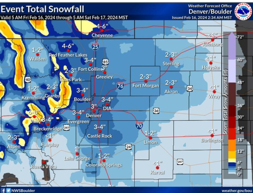
Expected snow totals for Fort Collins and Denver areas, Eastern Plains and Colorado mountains
According to the National Weather Service:
Fort Collins: 3 to 4 inches
Loveland: 1 to 4 inches
Greeley: 2 to 3 inches
Windsor: 2 to 3 inches
Estes Park: 2 to 3 inches
Wellington: 2 to 4 inches
Red Feather Lakes: 3 to 5 inches
Bear Lake (Rocky Mountain National Park): 4 to 7 inches
Cameron Pass: 4 to 8 inches
Buckhorn Mountain: 2 to 5 inches
Denver area
Denver: 2 to 3 inches
DIA: 2 to 3 inches
Boulder: 2 to 4 inches
Longmont: 2 to 3 inches
Eastern Plains
Fort Morgan: 2 to 3 inches
Sterling: 2 to 3 inches
Akron: 2 to 3 inches
Wray: 1 inch
Mountains
Winter Park: 6 to 8 inches
Vail: 6 to 8 inches
Steamboat: 3 to 4 inches
Eisenhower Tunnel: 3 to 6 inches
Keystone: 2 to 5 inches
— Miles Blumhardt
Fort Collins forecast to go from snow and cold to spring-like temperatures
Here is the forecast from the National Weather Service:
Friday: 70% chance of snow, mainly after 2 p.m., with daytime accumulation of around 1 inch. High near 32 degrees.
Friday night: 70% chance of snow, mainly before 2 a.m., with 2 to 4 inches of new snow possible. Low around 14.
Saturday: Patchy fog until mid-morning, with a high near 38 and low around 16.
Sunday: Partly sunny, with a high near 50 and low around 28.
Monday (Washington's Birthday): Sunny, with a high near 56 and low around 28.
Tuesday: Sunny, with a high near 62 and low around 31.
Wednesday: A slight chance of rain. Mostly sunny, with a high near 57 and low around 31.
— Miles Blumhardt
This article originally appeared on Fort Collins Coloradoan: More snow expected for Colorado, Fort Collins: Live updates on impacts

