Enjoy the warm weather, temps to drop Thursday in Bucks County. What to know
An unsettled weather pattern will stick over Bucks County through the weekend, with AccuWeather warning of potential hazards caused by Wednesday's storm, which will be followed by a roughly 20-degree temperature drop on Thursday.
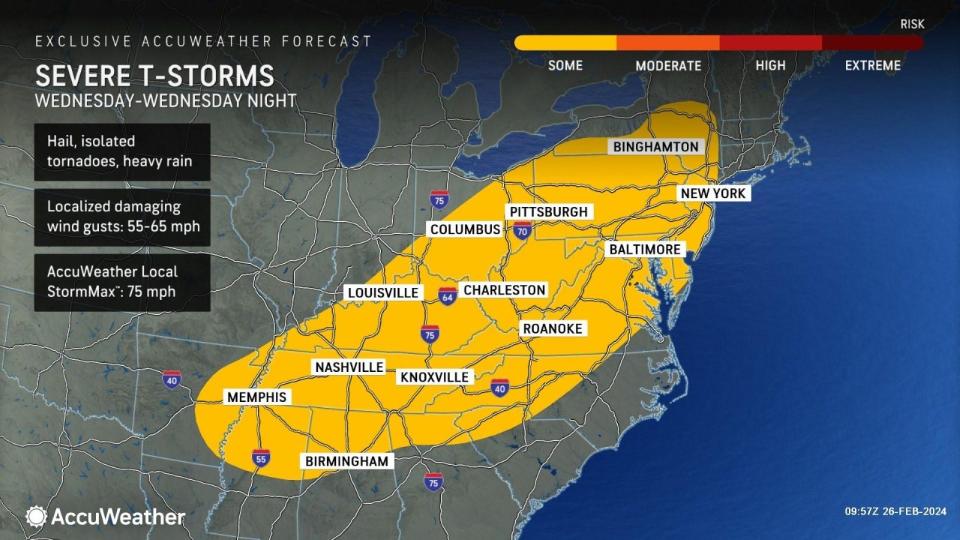
"There's potential for storms capable of causing property damage and localized power outages on Wednesday," read an alert from AccuWeather. "As the powerful cold front presses on toward the mid-Atlantic coast, storms will bring brief downpours and strong wind gusts, as opposed to a tornado threat.
"In some cases, the squally storms may occur without thunder and lightning by the time the storms reach the coast."
Wednesday's temperatures should reach 61 degrees, with wind gusts approaching 35 mph, according to the National Weather Service in Mount Holly's forecast.
Here's everything else to know about this round of storms and the double-digit temperature drop.
Wet, windy weather coming after Tuesday warm up
Eric Hoeflich, a meteorologist with the National Weather Service, said the next storm will develop Tuesday evening after a warm day.
"We are expecting periods of rain to last through Tuesday night and into Wednesday. There's no concerns about flooding; it will just be wet weather and certainly no snow," Hoeflich said. "We could have a rumble or two of thunder mainly on Wednesday evening, but it doesn't look like it will be anything too bad."
Was your car recalled? How to check: Ford, Toyota, Hondas among 2.3 million vehicles recalled. See if your car is included
As of Tuesday morning, the water level of the Delaware River at Trenton stood at 9.72 feet, and is expected to reach 13 feet on Thursday before receding. The flood stage of the Delaware River at Trenton is 20 feet.
Also as of Tuesday morning, the water level of the Neshaminy Creek at Langhorne stood at 1.56 feet and is expected to reach 3.9 feet on Wednesday before receding back to about 1.4 feet on Friday.
The flood stage for the Neshaminy Creek at Langhorne is 9 feet.
"We are more concerned with the winds," Hoeflich said. "The gusts will be close to 40 mph Wednesday night."
Gusts could even get as high as 45 mph during Wednesday's overnight hours, leading to a sunny, but very chilly Thursday.
Thursday's high will be roughly 41 degrees, with winds of 20 mph, and gusts nearing 30 mph.
"It shouldn't be anything too extreme," Hoeflich said. "Once the cold front comes through, we will see tmeperatures drop from the 60s on Wednesday to upper 30s Thursday morning, so some standing water might freeze.
"We should start to warm up this weekend."
'Rocky Festival' in Philly: Philadelphia's 'Rocky Day' to expand into 'Rocky' festival this year. Here's what to know
Mixed bag of sun, wind and rain Friday through Monday
Friday will be sunny, with highs in the low 50s, according to the National Weather Service's forecast. There's a slim chance it may rain overinight.
That chance of rain extends into Saturday, with rain expected before 1 p.m. Otherwise, Saturday will be mostly cloudly, with temperatures near 56.
The sun returns on Sunday, when it will be partly cloudy with temperatures in the high 50s.
The workweek begins with a 30% chance of rain on Monday, and mostly cloudy throughout. Monday's temperatures will hover arounf 57 degrees.
This article originally appeared on Bucks County Courier Times: Bucks County weather forecast: Warm weather ends with storm, cold

