Flood watch, high wind advisory for Salisbury heading into weekend: All to know
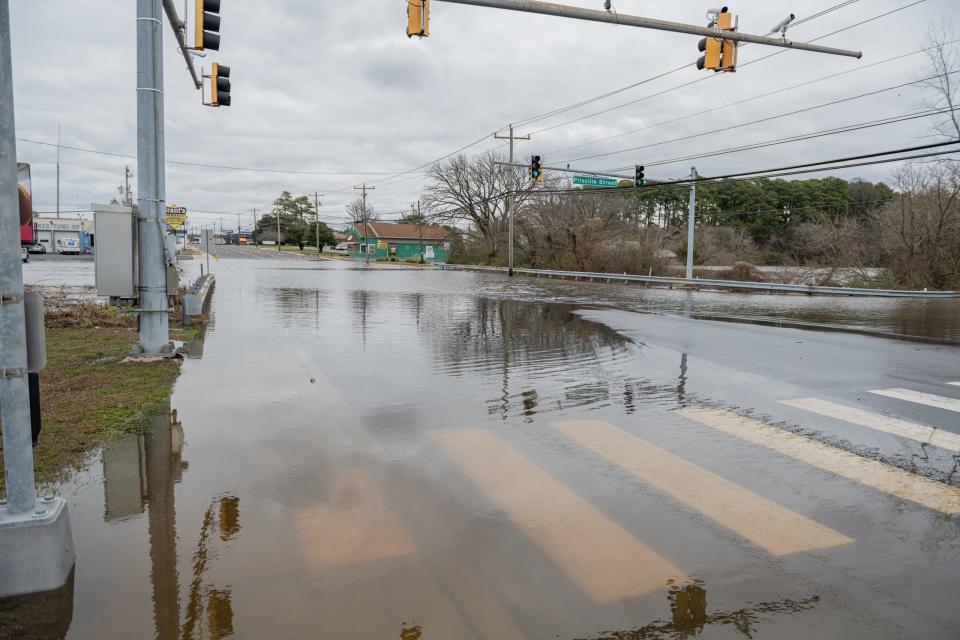
After a storm brought flooding to downtown Salisbury this week, there's another flood warning set for late Friday night/early Saturday morning, plus more heavy winds.
Here's all to know.
New flood watch, wind advisory in effect for Salisbury for early morning
The National Weather Service has issued a flood warning for Wicomico starting at midnight Saturday and lasting until 4 a.m. Here's what the NWS advised:
"Widespread flooding of vulnerable areas will result in an elevated threat of property damage to homes and businesses near the waterfront and shoreline. Water will be 1 to 2 feet above ground level in some areas resulting in a sufficient depth to close numerous roads and threaten homes and businesses. Flooding will extend inland from the waterfront along tidal rivers and bays resulting in some road closures and flooding of vehicles."
A wind advisory is also in effect for all of the Lower Shore of Maryland, including Ocean City, and the Eastern Shroe of Virgina from 7 p.m. Friday until 4 a.m. Saturday.
App tracks Maryland flooding: Flooding photographs can be put to good use with Maryland-backed app
The Friday/Saturday forecast for Salisbury
The NWS forecast calls for showers before 10 p.m. Friday, showers and possibly a thunderstorm between 10 p.m. and 4 a.m., then a chance of showers after 4 a.m. Low around 49 degrees, and windy, with a southeast wind 18 to 23 mph becoming south 24 to 29 mph after midnight. Winds could gust as high as 49 mph. Chance of precipitation is 90%. New rainfall amounts between a quarter and half of an inch possible.
Saturday will have a chance of showers before 7 a.m. Sunny, with a temperature falling to around 45 by 5 p.m. Breezy, with a west wind 15 to 24 mph, with gusts as high as 41 mph. Chance of precipitation is 30%. New precipitation amounts of less than a tenth of an inch possible.
Bay oysters thriving: Oysters enjoy 'prolific' year all around Chesapeake Bay. Here's what to know.
High surf advisory as huge waves expected in Ocean City
After Tuesday's storm brought huge waves to Ocean City earlier this week, a new high surf advisory is now in effect for 10 p.m. Friday through 10 a.m. Saturday. That advisory extends also to coastal areas of Virginia's Eastern Shore, including Chincoteague.
Here's the Friday/Saturday forecast for Ocean City from the NWS:
Showers before 10 p.m. Friday, showers and possibly a thunderstorm between 10 p.m. and 4 a.m., then a chance of showers after 4 a.m. Low around 49. Windy, with a southeast wind 23 to 28 mph increasing to 29 to 34 mph after midnight. Winds could gust as high as 49 mph. Chance of precipitation is 100%. New rainfall amounts between a quarter and half of an inch possible.
Saturday has a chance of showers before 7 a.m. Sunny, with a high near 54. Breezy, with a west wind 17 to 25 mph, with gusts as high as 37 mph. Chance of precipitation is 30%. New precipitation amounts of less than a tenth of an inch possible.
Hattie's Trail opening: Hattie's Trail, honoring local black history in Eden, to open on Martin Luther King Day
This article originally appeared on Salisbury Daily Times: High winds, flood watch for Salisbury for weekend: All to know

