Get ready now: Indiana weather will change fast as winter blast brings frigid temps, high winds
The National Weather Service in Indianapolis continues to monitor the strong storm system expected to move into Indiana this weekend, bringing with it rain, high winds, frigid temperatures and snow.
While snow is expected, the high winds and plummeting temperatures starting Friday are what meteorologists say to watch out for the most.
The amount of snow that could come with this system remained unknown as of Friday morning, but the NWS Indianapolis office shared the most likely outcome is 1-2 inches for most areas north and west of the I-70 corridor.
NWS has been monitoring this system since late last week.
Temperatures will plummet into the 20s overnight with any lingering moisture on roadways freezing into black ice. In addition light snow may collect on roadways this evening and overnight, especially areas north of I-70. #INwx #indy pic.twitter.com/RzzgKKDsFV
— NWS Indianapolis (@NWSIndianapolis) January 12, 2024
Meteorologists recommend checking the weather frequently this weekend as the beginning phases of the storm sweeps in.
Current Indiana weather forecasts for Friday
Weather
Embedded content: https://www.weather.gov/images/ind/wxstory/Tab3FileL.png?92b35d59f47f97f09255b2c83dfafc64
Indianapolis weather radar
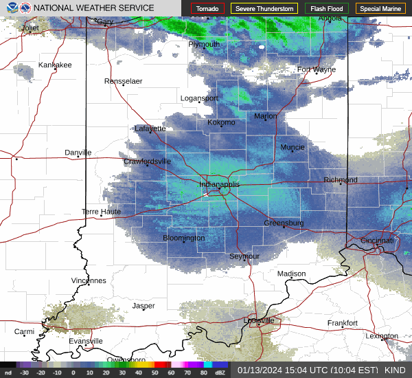
Starting Friday, two waves of rain will fall over Indianapolis. The precipitation will continue and slowly morph into snow flurries about 7 p.m. Strong winds will be felt throughout the day, but gusts will start to ramp up about 4 p.m. and could reach 55 mph. Temperatures are expected to hover around the low 40s and plummet to the upper teens and low 20s as the wind picks up.
Meteorologist Cody Moore said the wind advisory is in place until 4 a.m. Saturday morning and could be extended.
As for snow, Moore said the high winds on Friday will deter any from accumulating. The most likely outcome is Indianapolis recording less than an inch north of the city, toward Lafayette and Kokomo, to see a couple of inches, according to Moore.
He cautioned those intending to drive on Friday that the combination of rain and steep temperature drops create patches of black ice on the roads.
"Be cautious and allow extra time," he said.
On Saturday, there's a chance for snow showers before 9 a.m., then a chance of flurries from 9 a.m. to 1 p.m., according to NWS. Temperatures will hover around 24 degrees with breezy winds of 21-28 mph. Winds could gust as high as 48 mph.
Evansville weather radar
Evansville is expected to get rain on Friday with a temperature high near 48 degrees. It will be breezy, with an east-southeast wind 18 to 25 mph, with gusts as high as 39 mph. Chance of precipitation is 90%.
Friday night it will rain before 7 p.m., then snow is likely; possibly mixed with rain until 1 a.m., then a chance of snow after that. It will be mostly cloudy, with a low around 20 degrees, breezy, with a west-southwest wind 25 to 28 mph, with gusts as high as 39 mph.
On Saturday, forecasters with NWS predict partly sunny skies with a high near 32 degrees. Conditions will be breezy, with a west wind of 13-21 mph, with gusts as high as 33 mph. Saturday evening should be mostly cloudy, with a low around 7 degrees. The wind chill could be as low as -6 degrees.
Fort Wayne weather radar
Snow likely before 2 p.m. on Friday, then a mix of rain and snow. The temperature high will be near 37 degrees and breezy. Chance of precipitation is 100%. New snow accumulation of 1-3 inches is possible.
Rain and snow are expected Friday night, becoming all snow after 11 p.m. with a temperature low around 23 degrees. It will be blustery. Chance of precipitation remains 100%. New snow accumulation of 2-4 inches is possible.
On Saturday, more snow is likely, according to NWS, mainly before 11 a.m. The skies are expected to be cloudy with a high near 26 degrees. Conditions will be windy, with a west wind of 25-30 mph, and gusts as high as 50 mph. Chance of precipitation is 60%. New snow accumulation of less than one inch possible, according to NWS.
South Bend weather radar
South Bend is expected to get snow on Friday. The snow could be heavy at times. The temperature high will be near 34 degrees and breezy. Chance of precipitation is 90%. New snow accumulation of 2-4 inches is possible.
Friday night is expected to have more snow that could come down heavy. The temperature low is around 23 degrees and blustery. Chance of precipitation remains 100% that night. New snow accumulation of 3-5 inches is possible.
On Saturday, forecasters predict snow before 2 p.m. Temperature will fall to around 21 degrees by 5 p.m. and conditions should be breezy, with a west wind 20-25 mph, and gusts as high as 45 mph. The chance of precipitation is 90%, according to NWS, with new snow accumulation of 1 to 3 inches possible.
Driving in the snow: Indiana has snow in the forecast. Here's how to drive with common sense in icy weather
Be prepared for winter weather
While the severity of the storm is unknown, it is important to make sure you are prepared. Meteorologist Greg Melo recommends having a preparedness kit in your car and home and layer up if you need to go outside.
"Make sure you have any kind of preparedness kits that you need in your house to stay warm and if you have to go outside to make sure you're bundled up," Melo said.
NWS has a Winter Preparedness Checklist on its website with recommendations for what to include in your kits should you need them.
Indianapolis residents can follow the Indy Department of Public Works on X, formerly known as Twitter, for updates about snow removal.
Indy Department of Public Works also manages Indy Snow Force, their winter weather operations team, with an online map showing what roads have been plowed already in the city.
The Indy Snow Force road map can be found online at maps.indy.gov/IndySnowForceViewer. You can also follow them on X, @IndySnowForce.
Katie Wiseman is a trending and breaking news intern at IndyStar. Contact her at klwiseman@gannett.com. Follow her on Twitter @itskatiewiseman.
This article originally appeared on Indianapolis Star: Indiana weather forecast: Rain, freezing temps blow in with winter storm

