Lake Shasta 'too high' for February so Shasta Dam to release more water
Winter storms continued to fill Lake Shasta this week, dropping almost half a foot of rain into the reservoir in three days.
Even with increasing amounts of water being released from Shasta Dam, Lake Shasta rose 6.2 feet between Feb. 17 and 11 a.m. Wednesday Feb. 21, according to Don Bader, area manager for the U.S. Bureau of Reclamation, which manages Shasta Dam.
Bader said water levels are 20.8 feet from the very top. The lake is 1,046.2 feet above sea level — and 33.3 feet above where it was on Jan. 1.
As of Feb. 20, Shasta Lake was 87% full, and contained 124% of the water it's usually holding on that date. Much of the water arrived since mid-January, when the lake contained 113% of the water it usually holds at that time of year, according to the state.
Read more: On the wave of a wet winter, here's how water supplies are shaping up in 2024
While Shasta County will have the rest of the week to dry out, more rain is on the way starting Sunday, according to the National Weather Service.
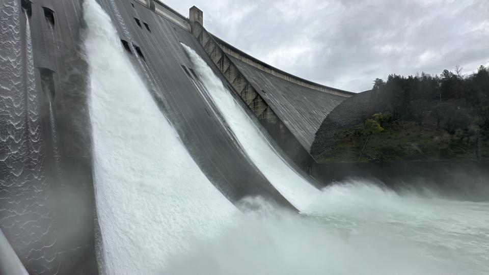
With less than 21 feet "from the top of our storage maximum," Lake Shasta's waters are too high for this time of year, Bader said. So starting Thursday, the Bureau of Reclamation will increase the amount of water it releases from Lake Shasta through the dam to 35,000 cubic feet per second — up from 25,000 cfs on Wednesday.
"We want to leave enough room” to hold water from any future storms in February and March, while still minimizing flood risk downstream, said Bader, who hopes to get the reservoir down to 82% to 84% full by Feb. 29.
Glory Hole in Redding: 'Emergency overflow valve' at Whiskeytown Lake spills for the first time in 2024
The bureau started releasing more water than usual on Jan. 30. Before then, "we were doing normal winter releases of 5,000 cfs," Bader said.
How much rain fell this week at Lake Shasta and Redding?
Lake waters are brimming in part because the latest of this winter's wet storms dumped 5.16 inches of rain on Lake Shasta between Sunday and Tuesday, according to the National Weather Service.
Since Jan. 1, a total of 31.37 inches of rain fell at the dam, well beyond its 19.22-inch historic average for the year up to Feb. 20, according to the agency.
Read more: Is Prop 1 the answer to homelessness in Shasta, Siskiyou counties?
Note to readers: If you appreciate the work we do here at the Redding Record Searchlight, please consider subscribing yourself or giving the gift of a subscription to someone you know.
As usual, Redding Municipal Airport got less rain than Lake Shasta received during the same three days, Shoemaker said: 1.61 inches.
But 2024 is so far a very wet year for Redding, too. Since Jan. 1, winter storms dropped 12.7 inches of rain on the city, compared to the 10.01 inches Redding usually gets by Feb. 20, Shoemaker said.
A few days of drier weather arrives during the second half of this week, but more light showers could show up as early as Sunday.
This winter's rain and a wet water year in fall and winter 2023-2024 went a long way to repairing damage to North State ecosystems, which were pummeled by three years of drought, Bader said.
Dry weather continues in parts of Siskiyou and Modoc counties
Although much of the state is getting soaked this winter, some Northern Californians still struggle with dryer-than-average conditions.
Parts of northern Siskiyou and Modoc counties, and eastern counties along the Nevada border from Lassen to El Dorado, are abnormally dry, according to the weather service and the National Drought Mitigation Center.
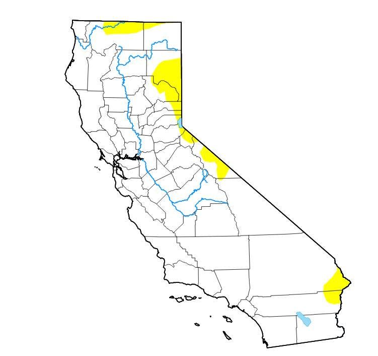
Dry soil and vegetation means 2024 could be an "active fire season" and farmers in dry areas will likely have to irrigate their fields earlier than usual, according to the U.S. Drought Monitor.
Northern California received less of a benefit from extremely wet storms that dropped rain on most of the southern and central parts of the state, according to the California Department of Water Resources.
Read more: After operating in Burney for nearly nine decades, this historic restaurant's for sale
But winter storms filled reservoirs enough to allow more water to go to parts of California than state officials had predicted earlier this winter.
The Bureau of Reclamation and the Department of Water Resources on Wednesday announced larger than expected water allocations for areas from Oroville to Los Angeles. But that won't help parched areas near the Oregon border, water department spokesman Ryan Endean said, since California's water flows south.
Jessica Skropanic is a features reporter for the Record Searchlight/USA Today Network. She covers science, arts, social issues and news stories. Follow her on Twitter @RS_JSkropanic and on Facebook. Join Jessica in the Get Out! Nor Cal recreation Facebook group. To support and sustain this work, please subscribe today. Thank you.
This article originally appeared on Redding Record Searchlight: Shasta Dam releases more water. Lake Shasta just 21 feet from the top.

