UPDATE: Winter storm warnings issued for Hagerstown, Chambersburg, Martinsburg areas
UPDATE at 10:45 a.m. Friday, Jan. 5, 2024: The National Weather Service has issued a winter storm warning for Saturday morning through evening that includes Washington and Frederick counties in Maryland; Franklin and Fulton counties in Pennsylvania, and Berkeley, Jefferson and Morgan counties in West Virginia. The warning for local Pennsylvania extends into Sunday morning.
The warnings state that heavy mixed precipitation is expected, with total snow and sleet accumulations in excess of 3 to 6 inches for local Maryland. Up to a quarter inch of ice also is possible.
For local Pennsylvania, snow accumulations of 5 inches to 8 inches are possible. A wintry mix is possible.
For local West Virginia, heavy mixed precipitation is expected, with total snow and sleet accumulations of 3 inches to 6 inches; 1 inch to 3 inches over lower elevations of the central Shenandoah Valley. Ice could accumulate from 1/10 of an inch to 1/4 of an inch.
Travel conditions could be difficult, including slippery roads.
More: Snow is in the forecast. If you live in Hagerstown, here's what you need to know
UPDATE at 3:55 p.m. Thursday, Jan. 4, 2024: The National Weather Service has issued a winter storm watch for Saturday morning through evening that includes Washington and Frederick counties in Maryland; Franklin and Fulton counties in Pennsylvania; and Berkeley, Jefferson and Morgan counties in West Virginia.
The watches state that heavy mixed precipitation is possible, with total snow accumulations in excess of 4 to 5 inches, depending on the area. For Washington County, in excess of 5 inches; for the Pennsylvania region, 4 to 7 inches; and for the West Virginia area, more than 5 inches.
Ice accumulations of more than a 1/4-inch could occur in the Maryland and West Virginia region with a light glaze possible in Pennsylvania.
Travel conditions could be difficult, including slippery roads.
------------------------------------
National Weather Service meteorologists are advising Tri-State area residents to stay off the roads during this weekend's winter storm, if they can. Otherwise, take your time.
The storm is expected to start Saturday with snow and end Sunday with snow, with a chance for a wintry mix in between. Windy conditions will contribute to wind chills in the 20s Sunday morning.
Snow accumulation totals range from 3 to 9 inches, with snow expected to stick to untreated surfaces.
How much snow, wintry mix is forecast for the Hagerstown, Martinsburg, Chambersburg areas?
Washington County and Berkeley County, W.Va., can generally expect 3 to 5 inches of snow and wintry mix, said meteorologist Eric Taylor with the weather service's Baltimore/Washington forecast office.
There could be more precipitation in the higher elevations toward the Catoctin Mountains in northern Frederick County, along South Mountain in Washington County and in the Sideling Hill area in western Washington County, Taylor said.
If a weather band sets up, there could be reports of 6 inches in those areas, he said.
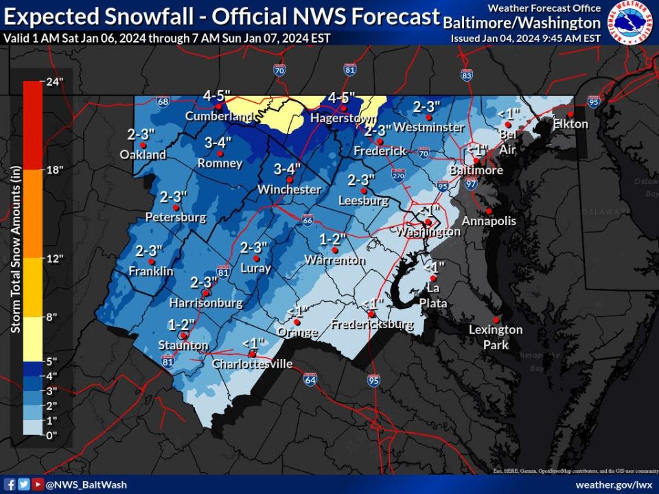
Accumulation totals also could be higher to the north as Chambersburg, Pa., could see upwards of 6 inches or possibly up to 8 inches, give or take, said meteorologist Sonya Lewis with the State College, Pa., forecast office.
Residents in the Greencastle and Waynesboro areas in southern Franklin County, Pa., could see slightly less, maybe closer to 6 to 7 inches, Lewis said.
Folks to the west in the Mercersburg area could see more snow, possibly 7 to 9 inches depending on elevation, she said.
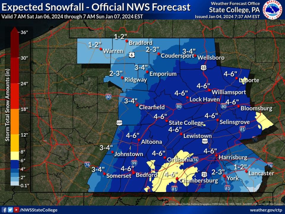
The forecast models were still jumping around a bit Thursday morning regarding how much snow and when it will arrive, but weather service officials were fairly confident Franklin County is getting "some sort of snow," she said.
Taylor said confidence was relatively high at the Baltimore/Washington forecast office for impacts from the event, though snowfall totals could depend on the track of the weather system. There could be subtle differences, he said.
When will precipitation be the heaviest?
The heaviest precipitation in Washington and Berkeley counties is expected Saturday afternoon into the evening, Taylor said. Sleet and a bit of freezing rain could join the snow as early as mid-Saturday afternoon, though the timing of that mix was not certain. More of a wintry mix is expected to occur during the evening.
By Sunday morning it will be snow again, with that tapering off in the late morning to midday, he said.
The heaviest precipitation in southern Franklin County is expected during late Saturday afternoon into the evening, Lewis said.
W.Va. man held without bond: Martinsburg man steals two cars in Hagerstown area in three days, reaches 100 mph fleeing
For Franklin County, the wintry mix is forecast to start later, into Sunday morning and afternoon, she said. The storm should wrap up around late Sunday morning to early afternoon.
Forecasters are anticipating precipitation to start around daybreak Saturday morning below the Maryland-Pennsylvania state line and during the late morning to early afternoon to the north.
How cold and windy will it be?
On Sunday morning, winds out of the northwest will be 10 mph to 15 mph with gusts up to 30 mph in Washington and Berkeley counties, Taylor said.
Saturday also will be windy with gusts upward of 30 mph to 35 mph during the late afternoon and evening. Those winds will be out of the west, and then shift to come from the south and southeast.
With winds, the temperatures will feel like the low to mid 20s through Saturday afternoon and evening, and then back to the mid to upper 20s on Sunday, Taylor said.
In southern Franklin County, Lewis said winds will pick up Saturday evening, with gusts up to 10 mph to 15 mph.
Maryland population shifts: Eastern Shore, Southern and Western Maryland attract residents departing metro areas
Wind chills on Saturday will make the high temperatures feel like the mid to high 20s.
On Sunday, the temperature will be right around freezing at 32 degrees. But with the wind, it will again feel like the mid to high 20s, she said.
Meteorologists expect some snow melt to begin Sunday, but that it will refreeze Sunday night before melting more on Monday.
This article originally appeared on The Herald-Mail: NWS forecasts snowstorm in Hagerstown, Chambersburg area Jan. 6 and 7

