Nor'easter, snow and storms forecast across New England through Tuesday
A fast-moving storm pushing through the eastern half of the country could bring major disruptions to travel in the Northeast through Tuesday.
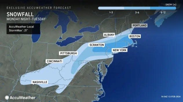
Widespread heavy snowfall was expected across northern Pennsylvania and southern New York late Monday, then southern New England on Tuesday morning, the Weather Prediction Center forecast said.
Boston is the biggest city in the path of the storm, forecasters said, where up to a foot of snow was possible. Schools in Boston will be closed Tuesday.
The probability of more than 8 inches of snow was 70% to 90% along a swath on the Pennsylvania/New York border and across most of Massachusetts, according to the weather prediction center.
Snow has started across Southern states
Snow was already reported across several Southern states Monday, as winter storm advisories and warnings remained in place Monday afternoon across portions of Oklahoma, northern Arkansas, southern Missouri and northern Kentucky. Earlier, the storm had dumped as much as 14 inches of snow in Plainview, Texas.
Just which areas of New England could be hit hardest will be determined as the storm develops, said David Roth, a meteorologist with the Weather Prediction Center in College Park, Maryland.
An intensifying Nor’easter along the coast was forecast to cause “moderate coastal flooding” at high tide along the Jersey shore and portions of the New England coast, which has already seen at least two big coastal flood events this winter, as well as higher than normal tides over the weekend.
Fortunately, the system will be faster-moving, which reduces the risks, Roth said. “This doesn’t have the hallmarks of a record event.”
Rain and wind were forecast in southern Louisiana but were expected to clear out in time to prevent major interruptions to Mardi Gras festivities in New Orleans, he said.
Excessive rainfall could lead to flash flooding in mid-Atlantic
Areas across parts of the southern Appalachians and the southern mid-Atlantic faced a risk of excessive rainfall into Tuesday with a chance for local flash flooding as the system moves through.
A new low will form over North Carolina that will move into the mid-Atlantic, Roth said. The path of that movement will help determine where the storm’s worst effects will be felt.
“Boston seems like the major city impacted, with a slight chance closer to New York City,” Roth said.
Onshore winds could push the ocean up into inland rivers and increase the chances for coastal flooding, he said.
The storms will see enhanced rainfall because a lot of moisture is flowing up over Mexico along with moisture moving into the region from the Gulf of Mexico, Roth said. “You’re getting moisture from both oceans, at multiple levels, and that’s why we’re experiencing some flash flooding.”
Warmer than normal sea surface temperatures in the Pacific have been helping boost rainfall in systems coming off the Pacific this winter.
This article originally appeared on USA TODAY: Storms to bring rain, snow across eastern US on Monday and Tuesday.
