Possible tornadoes, coldest temps of season expected for Florida. Here's what to expect
As Florida residents recover from Tuesday's storms and tornadoes, what they probably don't want to hear is the possibility more storms are on their way.
And we don't have much time to prepare, especially for those living in homes damaged or destroyed.
AccuWeather warned many of the same areas that experienced severe weather this week will again be dealing with potentially damaging storms at the end of the week.
"There will be another threat for severe storms over the Gulf Coast Thursday night into Friday with the next storm," said AccuWeather Meteorologist Elizabeth Danco. "Flooding rainfall and hail can occur with any of these thunderstorms."
Tornadoes confirmed: National Weather Service confirms multiple tornadoes punched Florida, including powerful EF-3
When is the next round of severe storms expected to hit Florida?
I don't like showing loops of operational models because details are often lost in time. However for the sake of argument on how active we are I wanted you to see high impact powerful storms that will unleash COLD ARCTIC AIR across the central USA from border to border by the… pic.twitter.com/JNaximHOuH
— Jim Cantore (@JimCantore) January 10, 2024
Expect severe weather to arrive Friday, Jan. 12, warned the National Weather Service, Tallahassee.
Timing of the severe thunderstorms could start Thursday night and continue through Friday evening, the National Weather Service Jacksonville said.
The storms are part of a system expected to move across Midwest, South and East from late Thursday into Saturday, forecasters said.
What types of weather can Florida expect Friday from an approaching cold front?
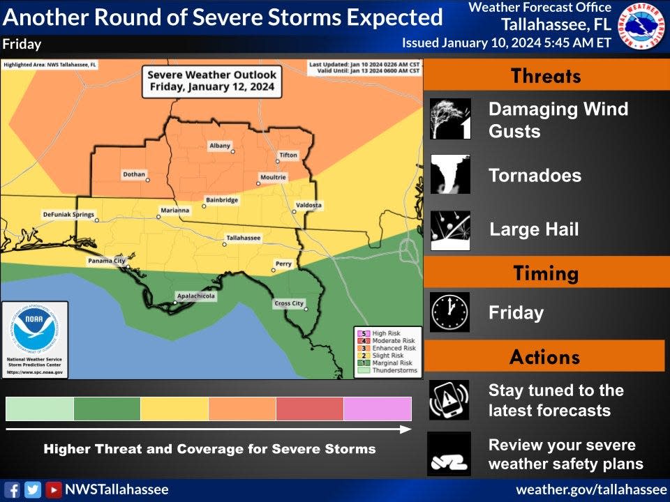
Friday's storms have the potential of bringing tornadoes, damaging winds, large hail and isolated heavy rainfall, the National Weather Service said in a tweet. Wind gusts could exceed 40 mph.
The storms are developing out of a cold front approaching the Southeast Friday and a warm front moving north out of the Gulf of Mexico.
"Rain chances increase with the possibility of severe storms during the day as supercells may develop ahead of the squall line," the National Weather Service said.
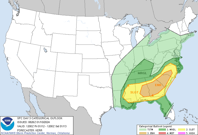
The Storm Prediction Center puts areas north of the Florida state line in an enhanced risk (3 of 5) for severe weather, with areas to the south in a slight risk (2 of 5). The rest of the state, with the exception of South Florida, is under a marginal risk (1 of 5) for severe weather.
There's a 15% chance for severe thunderstorms across North Florida Friday. As the system moves east, the strong cold front will move along the I-10 corridor during the afternoon and evening and then throughout the Florida Peninsula during the overnight hours, the Florida Division of Emergency Services said.
Isolated strong to severe thunderstorms will be likely along portions of the northern Peninsula and towards the I-4 corridor, Friday. Like the previous system, the quick-moving nature of this system will lead to all hazards of severe weather possible including damaging wind gusts (45-60 mph), isolated tornadoes, hail and heavy downpours.
What's the Florida weather forecast for the MLK holiday weekend?
The cold front will push through the state Friday night.
Expect warmer and drier daytime temperatures Saturday and Sunday. Wind gusts of 20 to 25 mph will be possible across the Panhandle and North Florida Saturday morning and into the afternoon behind the strong cold front, the Florida Division of Emergency Services said in its five-day forecast.
On Monday, an apparent strong cold front will approach the state, bringing with it an increased chance for rain. Behind the front, expect the coldest temperatures of the season by Tuesday. Highs in Tallahassee could drop to the upper 40s to mid-50s and overnight lows could fall into the mid-20s by Tuesday night, the National Weather Service Tallahassee said.
A polar vortex is poised to bring the coldest air of the season across the central and eventually eastern U.S. over the next week, the National Weather Service said. By Monday morning, 88% of the contiguous U.S. could see below-freezing temperatures.
How low will temperatures drop in Florida?
Behind the cold front, high temperatures will fall into the low to middle 50s across North Florida, middle 50s to middle 60s across Central Florida and middle 70s to low 80s across South Florida, according to the Florida Division of Emergency Services.
Overnight Friday low temperatures will fall into the 30s and low 40s across North Florida, upper 40s to upper 50s across Central Florida, and middle 60s to low 70s across South Florida.
There is a chance for patchy frost to develop overnight and early Saturday morning along portions of the interior Panhandle and Suwannee River Valley.
Overnight temperatures Saturday are expected to fall into the low to middle 30s across North Florida through Nature Coast, upper 30s to middle 40s across Central Florida, and 50s and low 60s across South Florida and the Keys.
There may be a chance for patchy frost and a light freeze will be possible overnight Saturday and into Sunday morning depending on the cloud cover and light winds.
Worst of storms expected to impact North Florida, Panhandle but rest of Florida could feel effects
As the warm front moves north across Central Florida Thursday night and early Friday, expect to see increased rain chances and isolated storms, the National Weather Service Melbourne said.
"Increasing wind fields on Friday afternoon and evening will bring a risk of strong to marginally severe storms from Osceola and Brevard counties northward.
"The primary threats will be strong wind gusts and lightning strikes. The next cold front is forecast to push across the area early Saturday. Unsettled weather is forecast to return Monday and Tuesday with isolated storms."
As the system approaches South Florida toward the end of the week, "strong winds and hazardous marine conditions may materialize once again periodically over the weekend," the National Weather Service Miami said.
Tornadoes? NWS sending survey teams to assess damage across Florida
Whether Florida was hit by tornadoes Tuesday — and if so, how many — will be determined by the National Weather Service.
The National Weather Service office in Tallahassee said it plans to send out three survey teams Wednesday and two additional teams Thursday to survey suspected tornado damage.
Teams on Wednesday will be surveying suspected tornado damage in Walton, Bay and Jackson counties in Florida. Other teams will head to Georgia and Alabama.
The National Weather Service Jacksonville also will be sending out survey teams today.
One team will be surveying suspected tornado damage in St. Johns and Duval counties. Another will be heading to several counties in Georgia.
This article originally appeared on Treasure Coast Newspapers: Florida weather forecast: Cold front, tornadoes, strong storms

