Seacoast NH and Maine brace for heavy rain, high winds, flooding in coming storm
Avoiding shoveling the snow that piled up in Sunday’s snow storm? That strategy could work if you can hold out a couple days. By the end of Wednesday, most of the accumulation should be melted away due to a warm, rainy and wind-filled system moving toward the region.
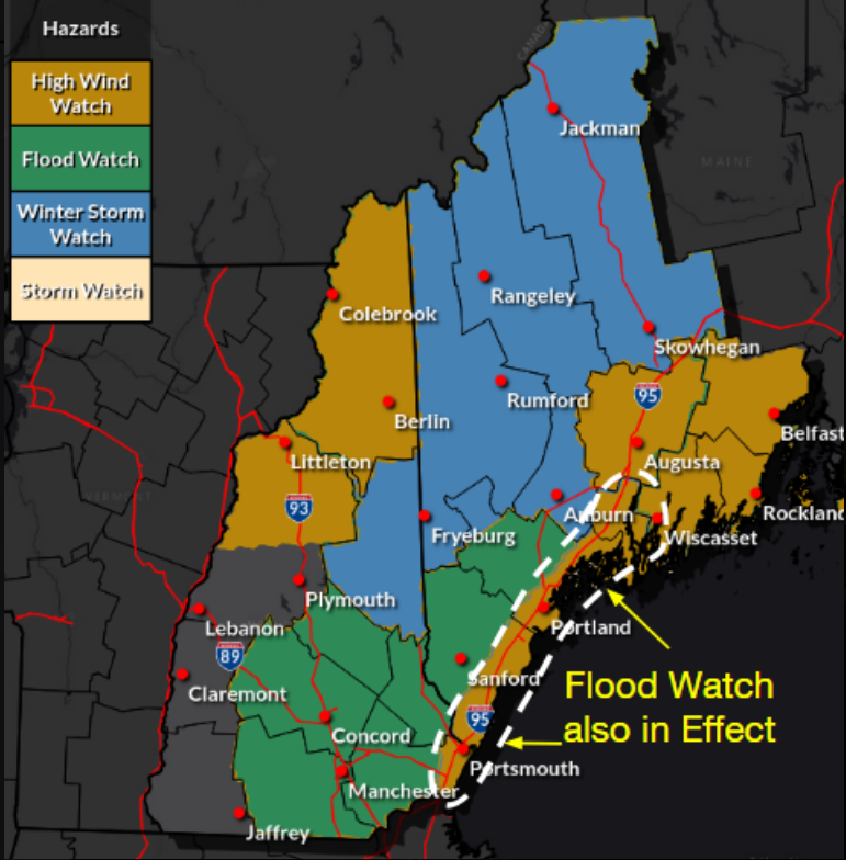
The coming storm is expected to have wide-ranging impact in the Seacoast, and throughout New Hampshire and Maine. It is forecast to move into the region Tuesday night, bringing with it storm and high wind and flood watches throughout the two states, according to the National Weather Service in Gray, Maine.
Locally, light snow is expected to be followed by heavy rainfall, high winds, unseasonably warm temperatures and possible coastal flooding.
“Tuesday night we’re anticipating the precipitation to move into the region maybe a little after dinner time,” meteorologist Jon Palmer said Monday morning. “It’ll start out as snow in the interior portions of the Seacoast and York County in Maine, but as you go closer to the coastline, it’ll rain mostly to start out. As the night goes on, warm air continues to move up into the region with all locations changing over to rain by Wednesday morning. Rain will continue through the day on Wednesday and the storm will exit the region by dinnertime on Wednesday.”
Initial Tuesday snowfall amounts will vary between communities before the all-rain switchover into Wednesday. According to Palmer, just over two inches could fall in Sanford, Maine, less than two inches in Rochester, roughly one inch in Dover and Somersworth, a “trace” of snow at Pease International Tradeport, and likely no accumulation along the New Hampshire coastline.
How fast will the snow melt?
Some communities in the Seacoast received a foot or more of snow on Sunday, but much of it could be short-lived.
Temperatures on Tuesday will be in the 30s before warming to above 40 degrees Wednesday morning and reaching the 50s in the afternoon, Palmer said.
“The snow that just fell could withstand quite a bit of rain,” Palmer said, predicting the new storm will be a "snow ablation event. ... I could make a pretty solid bet that at least 80% of the snowpack will be gone by the end of the day on Wednesday, if not more."
How much snow did we get?: NH and Maine totals listed here
Heavy snow to north of Seacoast
Areas north of Maine and New Hampshire’s coastal communities, particularly the White Mountains, are projected to receive another large amount of snow. On Mount Washington, the incoming storm could result in another 21 inches of snow before rain sets in, Palmer said.
On the Seacoast, forecasters predict upwards of two inches of rain on Wednesday.
“The Seacoast is most likely going to be the first area that changes over to rain. The Seacoast will be mostly rain if not all rain by midnight Tuesday into Wednesday,” Palmer added.
High winds could bring power outages
The coastline could see winds between 55 and 60 mph Wednesday morning, with communities in Rockingham County and Strafford County projected to get consistent wind gusts of 40 mph during the day. Later Wednesday, gusts could still top out at 35 mph.
High tides Wednesday morning in areas like Hampton may lead to ocean splashover and coastal flooding. The National Weather Service notes much of southern New Hampshire, including Portsmouth, is under flood watch, with the advisory in effect as far north as the Auburn, Maine, area.
In the Seacoast region, the potential for isolated to scattered power outages is also on the National Weather Service’s radar. Heavy, wet snow in the northern communities brings risks, too.
Portsmouth in 2024: Development surge in North End, Route 1 corridor
“This is a big, multifaceted system,” Palmer said. “There’s going to be a lot of impacts, a lot of rain, a good amount of wind. The wind is the big issue.”
The next storm’s radius is slated to impact the Great Plains, upper Midwest, the Gulf Coast, southeastern United States and mid-Atlantic region alongside New England, according to the National Weather Service’s Weather Prediction Center.
This article originally appeared on Portsmouth Herald: Seacoast NH, Maine brace for rain, high winds in next storm

