Severe storms, strong winds move through Cincinnati. But how long will it last?
A tornado watch issued Tuesday night for the Greater Cincinnati region was dropped at 6 a.m. Wednesday.
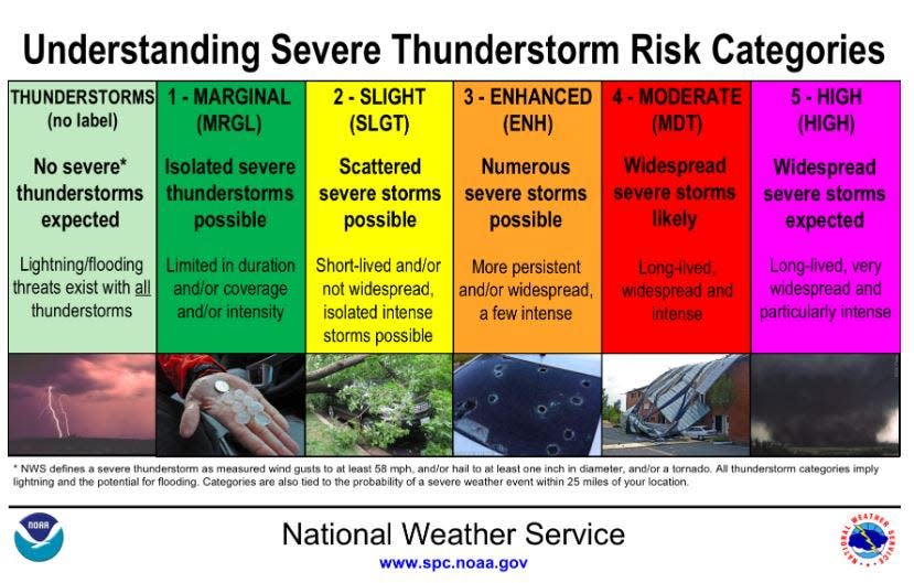
A hazardous weather outlook is still in effect in the region, with storms, hail and strong winds possible Wednesday.
Intense downpours with a lot of lightning moved through the region but no tornadic activity was reported in the region. There are reports of tornado damage near Dayton and Columbus.
In Greater Cincinnati, showers and possibly a thunderstorm are in the forecast before 11 a.m., then a chance of showers between 11 a.m. and noon. Some of the storms could produce heavy rain. New precipitation amounts between a tenth and a quarter of an inch, except higher amounts possible in thunderstorms.
Dry weather will move in this afternoon. The cold front that pushed in will bring a major cool down. The temperature was 64 degrees at 6 a.m. and is expected to fall to 38 degrees by 5 p.m. Temperatures will fall to 25 degrees overnight Wednesday into Thursday.
Skies will be mostly clear tonight and sunny on Thursday. Temperatures will fall a few degrees below normal, with lows in the 20s tonight followed by highs in the 40s on Thursday.
Winter Tornadoes: They're more common in Ohio than you think
Tornadoes touch down in Ohio
Tornadoes missed Greater Cincinnati, but the threat remains in Central Ohio. According to the Columbus Dispatch, there was a confirmed tornado sighting Wednesday morning in Madison County near the Franklin County border, moving west to east.
More: See where tornadoes may have struck in Ohio on Wednesday
Tornado debris was reported near West Jefferson along the Madison-Franklin border. A tornado touched down east of London moving eastward into Franklin County, the National Weather Service tweeted at 5:22 a.m.
At least one tornado also touched down in Clark County east of Dayton, FOX 19 reports. A radar-indicated tornado struck down in Clark County from Springfield through the county line just before 5 a.m.
Another possible tornado was reported nearby a few minutes later southeast of Springfield, moving toward South Vienna.
The Clark County Emergency Management Agency said in its news release that it received reports of multiple structures collapsing. The agency is working with local fire departments to assess the damage.
The NWS says it will also conduct damage surveys following severe thunderstorm activity that resulted in multiple areas of damage from Dayton to Columbus along the I-70 corridor. The final results of the surveys are expected to be completed over the coming days.
[6:15 am update] As the primary tornado-related activity in the Columbus, OH area shifts out of the area, strong storms remain possible in southern Ohio and northern Kentucky. At this time, tornado threat appears limited for these storms. Can't rule out hail and strong winds. pic.twitter.com/h7Xwh3CBM8
— NWS Wilmington OH (@NWSILN) February 28, 2024
Anderson Ferry closes due to high winds
Anderson Ferry shut down Wednesday due to high winds from the storms and will remain closed until further notice.
“Sorry for the inconvenience. The wind is now an issue. For the safety of our customers and staff we are now closed. We will keep an eye on the conditions and keep you posted,” operators posted on Facebook at 8:38 a.m.
FOX 19 reports that the Anderson Ferry, which has been operating for over 200 years, is the only automobile crossing between the Brent Spence Bridge along Interstates 71/75 and the Carrol Cropper Bridge. Two boats typically operate during peak hours.
Detailed Cincinnati weather forecast
Wednesday: Showers and possibly a thunderstorm before noon, then a chance of showers between noon and 1 p.m. Some storms could be severe, with large hail, damaging winds, and heavy rain. Temperature falling to around 39 by 2 p.m. Breezy, with a southwest wind of 18 to 21 mph becoming west in the afternoon. Winds could gust as high as 34 mph. The chance of precipitation is 100%. New precipitation amounts between a quarter and half of an inch possible.
Clear at night, with a low of around 25. West wind 9 to 14 mph.
Thursday: Sunny, with a high near 46. Northwest wind around 6 mph becoming southwest in the afternoon.
Partly cloudy in the evening, with a low of around 30. Southeast wind around 5 mph.
Friday: A chance of rain, mainly after 2 p.m. Mostly cloudy, with a high near 51. South wind 6 to 9 mph. The chance of precipitation is 40%. New precipitation amounts of less than a tenth of an inch possible.
A chance of rain before 2 a.m. Mostly cloudy, with a low of around 42. The chance of precipitation is 40%. New precipitation amounts of less than a tenth of an inch possible.
Saturday: Mostly cloudy, with a high near 62.
Sunday: Mostly sunny, with a high near 71.
Monday: A chance of rain. Mostly sunny, with a high near 73. The chance of precipitation is 30%.
Tuesday: A chance of rain. Partly sunny, with a high near 62. The chance of precipitation is 50%.
Source: The National Weather Service in Wilmington, Ohio.
This article originally appeared on Cincinnati Enquirer: Cincinnati weather: Severe storms, strong winds Wednesday morning

