'This event will go from 0 to 100 very quickly': EF-2 tornadoes, 70 mph gusts forecast
Update: 7:20 a.m.: Escambia Bay Bridge opens
The closure of the Escambia Bay Bridge has been lifted at this time, but motorists are advised to use caution as they travel around the area.
Tornado warnings canceled
The tornado watch for Escambia County was canceled at approximately 6:18 a.m. after the squall line moved through the area. While the tornado watch was canceled for Santa Rosa County at approximately 6:54 a.m.
Overnight, there were two tornado warnings and five severe thunderstorm warnings for the area.
Florida Power and Light reports that 3,962 customers in Escambia and Santa Rosa counties are without power.
Update 9 p.m.: Tornado watch issued; Escambia Bay Bridge closed to commercial vehicles
Escambia Bay Bridge has been closed to commercial vehicles such as semi-trucks and box trucks due to sustained high winds estimated at around 46-48 mph.
The bridge will remain closed until further notice. These type vehicle have a tendency to overturn from the winds on the bridge and the current speeds or higher. All other motorist use extreme caution on the bridge, if you are able to avoid traveling at all that would be suggested.
The following alternate route is suggested for safety:
Scenic Highway to US 90 to Avalon Blvd for eastbound
and Avalon Blvd to US 90 to Scenic Highway for westbound
Escambia and Santa Rosa counties are both under a tornado watch until 7 a.m. Tuesday.
Update 5:30 p.m.: In the latest update from the National Weather Service office in Mobile, Alabama, forecasters say areas east of Interstate 65, which includes all of Northwest Florida, have the greatest risk of seeing strong tornadoes as the storm system moves through, meaning EF-2 tornadoes or stronger.
An EF-2 tornado is rated a tornado that has a three-second wind gust of between 111 and 135 mph.
The weather service said the greatest risk for seeing tornadoes in the area that includes Northwest Florida is from 2 a.m. to 8 a.m.
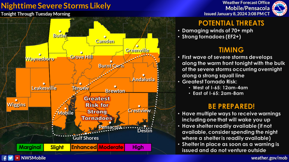
"No mincing words here, our concerns for the overnight period tonight is serious," the weather service said in a discussion of the area forecast. "An incredibly impactful system has begun across our area, and conditions will rapidly deteriorate throughout the night."
The severe weather is expected to impact the area in two or three rounds, the weather service said.
"This event will go from 0 to 100 very quickly," the weather service said, adding that similar weather setups have led to the region's strongest tornadoes in the past.
The final round will come in the early morning hours as the storms form into a squall line that moves from west to east over the region. This line of storms will bring wind gusts of 70 mph and will be "primed" to produce tornadoes.
"The compounding impacts of increased winds and ongoing rainfall to saturate the soil will make trees and power lines more susceptible to being blown over outside of any thunderstorms," the weather service said. "Because of this, power outages will be possible well before any severe thunderstorms arrive, so it is very important to have multiple ways to receive warnings overnight. Be sure to charge battery-powered methods of receiving warnings before going to bed and be sure to secure loose items outside."
Update 2:41 p.m.: The National Weather Service has expanded the high wind warning to cover all of Escambia and Santa Rosa counties until Tuesday at 9 a.m. Sustained winds of between 30 to 40 mph are expected, with gusts up to 60 mph.
A wind advisory will remain in place Tuesday from 9 a.m. to 6 p.m. with winds of 15 to 25 mph expected and gusts of up to 40 mph.
Original story: Severe thunderstorms are expected to bring high winds, tornadoes and flooding to Northwest Florida late Monday night and earlier Tuesday morning.
There is the potential for thunderstorms throughout the day on Monday, but the greatest risk for severe weather will happen overnight.
Weather alerts: Weather watches, warnings issued for Pensacola area. See radar, current conditions
Closings: Escambia County schools closed Tuesday due to severe weather
The National Weather Service has much of the entire Pensacola area in an "enhanced risk" for severe weather, which is level three out of five risk categories.
The risk includes the potential for a few strong tornadoes and "widespread destructive wind gusts" for the Gulf Coast region, according to the weather service's Storm Prediction Center.
The National Weather Service office in Mobile, Alabama, warned that a line of severe thunderstorms is expected to move into Northwest Florida around midnight bringing damaging winds in excess of 70 mph and the possibility of a few strong tornadoes in the EF-2 category or greater. The greatest risk for tornadoes will be between 3 a.m. and 9 a.m. Tuesday.
Escambia County Public Schools and the Santa Rosa County School District both announced Monday morning that schools will be closed Tuesday. Escambia County has canceled all extra-curricular activities for Monday.
Santa Rosa County said extra-curricular activities will end at 6 p.m. Monday, and all activities on Tuesday are canceled.
“We anticipate normal district operations will resume on Wednesday, Jan. 10," Escambia Superintendent Keith Leonard said in the announcement. “Of course, we'll continue to work closely with local emergency operations officials to determine what is safest for our families and staff.”
Get ready Florida: Forecasters say brace for possible tornadoes, damaging winds, flooding
The greatest chance of damaging winds is in areas south of Interstate 10. Southern Escambia and Santa Rosa counties are under a high wind warning beginning at 4 p.m. Monday until 9 a.m. Tuesday with expected sustained winds of 25 to 35 mph and gusts of more than 60 mph.
The rest of the area is under a wind advisory until 6 p.m. Tuesday, with sustained winds of 20 to 30 mph expected and gusts of up to 50 mph.
Coastal areas are also under high surf warnings and coast flooding advisories as waves are expected to build up to 10 feet by Tuesday.
🌪️Severe storms are possible tonight as a warm front lifts into the area and along an intense squall line that will move east through Tuesday morning. Damaging winds in excess of 70 mph and tornadoes are the main threats with a few strong tornadoes (EF-2+) possible. pic.twitter.com/ZiSngsJgFT
— NWS Mobile (@NWSMobile) January 8, 2024
The Gulf Islands National Seashore has already closed ahead of the storm. The campgrounds at Fort Pickens were ordered to leave by 10 a.m. Monday ahead of the weather.
Winds will ramp up through the day Monday, and there is the chance strong winds could cause trees to fall and knock out power lines before the arrival of severe weather. The weather service said because of the potential for power outages, it's important for people to have multiple ways to receive severe weather warnings for their area.
This article originally appeared on Pensacola News Journal: Pensacola weather Severe thunderstorms could bring tornadoes, flooding

