Shocking erosion along coastal RI the worst since Superstorm Sandy, experts say
It wasn’t just inland areas of Rhode Island damaged by last week’s storms.
While torrential rains inundated neighborhoods from West Warwick to Johnston to East Providence last Tuesday and again on Saturday, the state’s southern shore was pounded by wind-whipped waves that washed out beaches, dunes and even stretches of road.
The erosion in parts of South Kingstown, Westerly, Narragansett and Charlestown was the worst that coastal geologist Janet Freedman had seen since Superstorm Sandy in 2012. And that was based only on looking at some of the beaches after the first storm. She had yet to visit the coastline after the second one.
“These were the biggest since then,” said Freedman, who’s retired now after 22 years at the Coastal Resources Management Council.
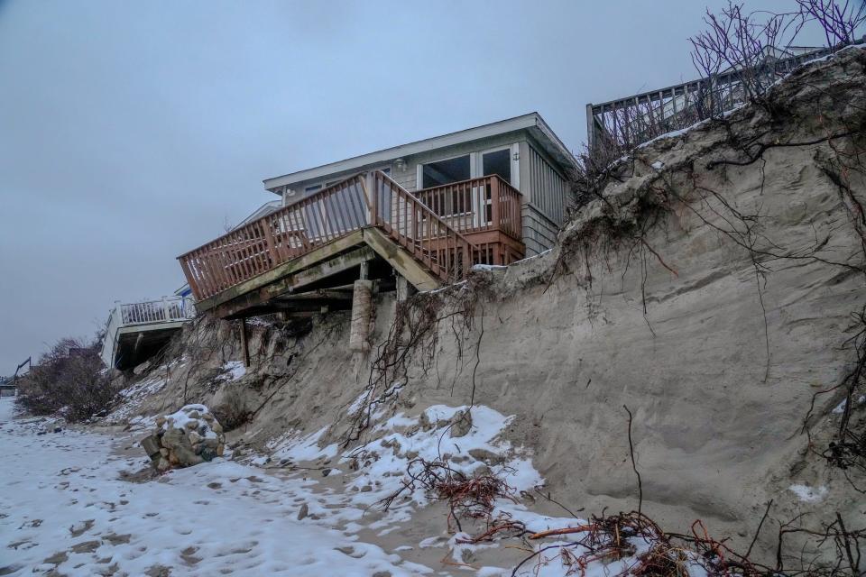
Roads washed out, foundations exposed, decks sagging on the sand
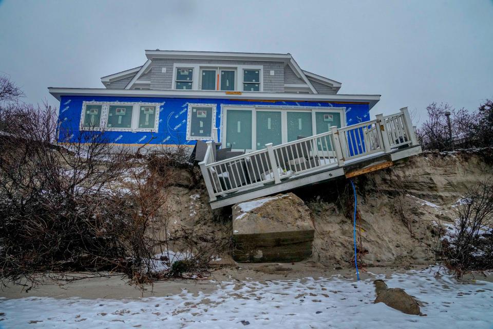
The damage could be seen all along the coast. On the South Kingstown side of Charlestown Beach Road, the storm ripped out an entire section of roadway, cutting off access to five houses. Waves undercut a building at one end of Narragansett Town Beach, leaving the foundation exposed and crumbling. Near Roger Wheeler State Beach in Narragansett, decks above the sand sagged on crooked pilings.
Staff with the CRMC and town officials were still inspecting the damage on Tuesday, but South Kingstown Town Manager James Manni said it was clear that the impacts were significant. He pointed to Matunuck Town Beach, where much of the sand had been carried away, leaving behind a rocky moonscape.
“There’s a 6-foot drop-off where the beach once was. I’ve never seen the beach erode to that point,” said Manni, who’s lived in South Kingstown for 25 years.
Some erosion is normal on the Rhode Island coast. Subject to the forces of winds and waves, the shoreline is locked in a constant cycle of change. Northeast winds in the winter bring waves that scour away the sand. And in the spring, southwest winds push in waves that carry back some of the sand stored in banks offshore.
But over time, the beaches have experienced a net loss, and the ocean continues to encroach. Scientists expect that the forces driving erosion will only grow more powerful as extreme storms become more frequent and as seas rise, amplifying the height of waves and allowing them to reach farther inland.
The impact can be seen in places like Matunuck, where the South Kingstown town beach is receding at a rate of nearly 5 feet a year, faster than anywhere else in the state, and where a sandy expanse fronting Matunuck Beach Road has experienced some of the highest amounts of historic erosion, losing more than 100 feet in places between 1939 and 2014 as it was winnowed down to what today is just a narrow strip.
A string of coastal storms
You have to go back a month to get a full picture of what happened along the coast. That’s when the first of this winter’s big storms occurred. Waves of about 30 feet were recorded offshore at a buoy near Block Island. That's close to the heights seen during Sandy, according to Bryan Oakley, chair of the Environmental Earth Science Department at Eastern Connecticut State University. When they reached the shore, they knocked down dunes that would normally protect inland areas.
Without those dunes in place, the waves from Tuesday’s storm reached farther inland, even though they weren’t as large as those in the December event. The waves in Saturday’s storm were even smaller, but their impact was intensified because the storm rolled in on a higher tide.
“The back-to-back nature of the storms really enhanced the damage, because you lose that first line of defense,” said Nathan Vinhateiro, science director of the University of Rhode Island’s Coastal Institute.
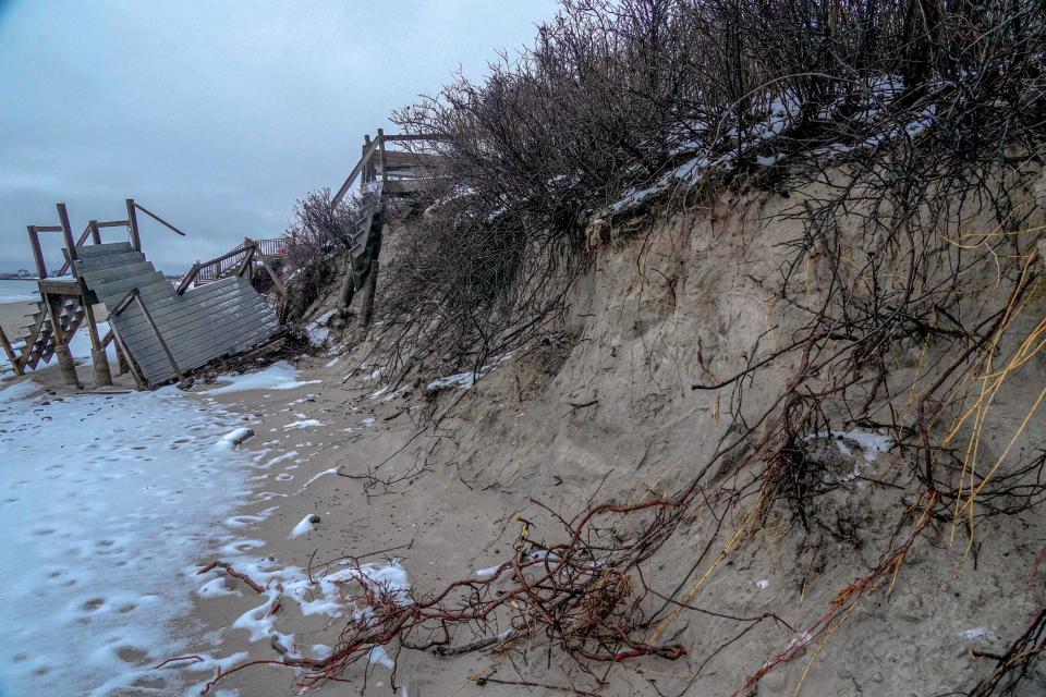
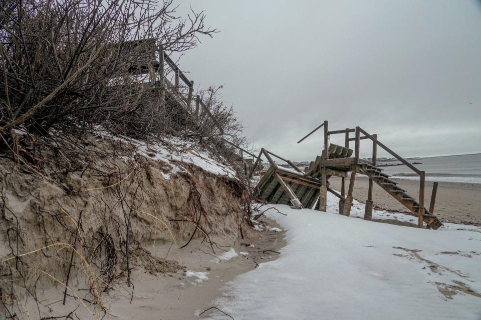
The effect was evident on Charlestown Beach Road, where structures built up to cross over high dunes now look like they’re suspended in mid-air with no sand underneath.
“They look like bridges to nowhere,” Vinhateiro said.
More: In retreat from rising waters, RI steps in to buy out flood-prone homes
It could also be seen on the northern side of Narragansett Town Beach, where the building near the Dunes Club sustained damage to its foundation after the loss of what Vinhateiro estimated to be 15 to 20 feet of dunes.
The power of the waves was also evident just nearby at the mouth of the Narrow River. Sand pushed back from a spit that juts into the river has reconfigured the tidal delta, shifting the boat channel over, said Freedman.
Something similar has happened over a longer period of time at Napatree Point in Westerly, which is moving back and forth with each new storm.
That’s how the rest of the Rhode Island coastline would behave absent human development. But seawalls, roads and houses along the shore create barriers that interfere with natural forces and, in many places, only exacerbate the rate of erosion.
A recovery is expected
To coastal experts, the damage from the succession of storms in such a short window of time was to be expected.
“Winter storms tend to do this,” said Laura Dwyer, spokesperson for the CRMC. “Having three in the span of about a month, it shows.”
Although many of the same places hit by Sandy were hit again, the impacts weren’t as bad this time around. That’s in part because Sandy was an unusually big storm. It lingered over several tidal cycles. The recent storms were each shorter in duration.
The good news is that the shoreline will recover. Within a matter of weeks, at least some of the sand should naturally return to Matunuck Town Beach and other beaches along the south coast.
Manni said the town will also look at trucking sand in. The more immediate focus is on repairing Charlestown Beach Road, he said. He’s set to meet on-site Wednesday with contractors to consider options.
The dunes along the shore will come back too, though it could take years for them to reach their previous size, said Oakley.
More concerning is what the storms could herald for the future.
“With these more frequent storms and with sea levels creeping up, we may see bigger impacts as we go forward,” Oakley said.
This article originally appeared on The Providence Journal: Storms heavily erode South County beaches. Will they recover?

