Snow alert: Weather Service says up to 8 inches of snow possible in northern Ohio
Friday weather update: Up to 7 inches of snow now expected in the area; schools cancel
It's a good news, bad news thing weather wise in northern Ohio.
The good news is things are about to warm up slightly across the region.
The bad news is winter is not going away anytime soon and heavy snow is in the forecast.
Winter storm watch for northern Ohio
The National Weather Service says the weather will be quite active over the next few days with bouts of snow that are expected to impact travel across northern Ohio.
A winter storm watch will be in effect from 1 a.m. Thursday to 1 a.m. Saturday for Erie, Huron, Lorain, Medina, Cuyahoga, Summit, Geauga, and Lake counties.
The weather service says "heavy snow" is possible across the region.
"Travel could be very difficult," the weather service said. "The hazardous conditions could impact the morning and evening commute."
Temperatures will be in the teens and the 20s through Sunday but rise above freezing by Monday.
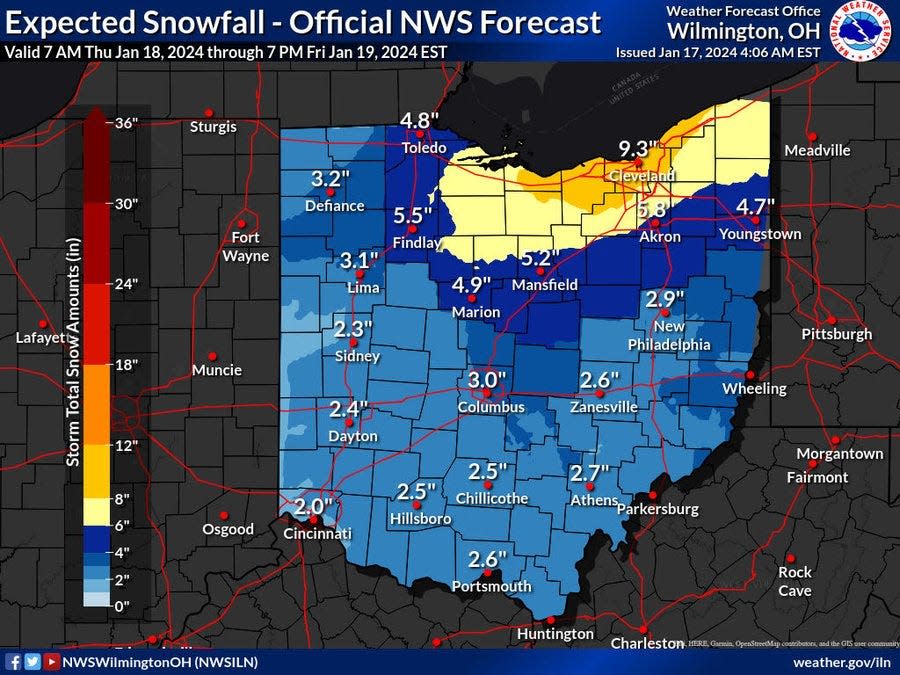
How much snow will Akron get?
The real weather story will be the anticipated snow from a series of storm systems that will make their way across the region.
Anywhere from 4 to 8 inches of snow are possible in Greater Akron, the weather service says, starting Thursday through Friday night.
"A widespread plowable snow is becoming likely late Thursday night into Friday," the weather service says.
The blast of Arctic Air that preceded the anticipated rounds of snow forced most schools across northern Ohio to close on Wednesday as dangerously cold wind chills made it unsafe for kids to walk to school.
Wednesday school closures: APS closed Wednesday due to cold temperatures, UA cancels early classes
When will the snow start in northern Ohio?
The first round of snow is expected between 10 a.m. to noon on Thursday with anywhere from 1 inch to 2 inches possible.
Snow showers will continue through the day with another round of general snow after 1 a.m. Friday with 1 to 2 inches possible.
The widespread snow is expected to continue through Friday with 2 to 4 inches of additional snow possible.
Snow showers Friday night could bring another inch.
The snow showers are expected to end in the region by 1 p.m. on Saturday.
Partly sunny skies are possible on Sunday with chances of rain on Monday and Tuesday.
Akron warming centers
To help residents cope with the cold temperatures, Akron plans to offer places for residents keep warm.
The Summit Lake Community Center at 380 W. Crosier St. is open as a warming center 8 a.m. to 7 p.m. through Friday along with the city's other community centers. The Emergency Overnight Shelter at 111 East Voris St. will be open 7 p.m. to 8 a.m. through Monday.
What's the weather forecast?
Wednesday: Sunny, with a high near 20. Wind chill values as low as -11. Southwest wind 13 to 16 mph, with gusts as high as 28 mph.
Wednesday night: A slight chance of snow after midnight. Cloudy, with a low around 17. Southwest wind 9 to 14 mph, with gusts as high as 24 mph. Chance of precipitation is 20 percent.
Thursday: Snow likely, mainly between 10 a.m. and noon. Cloudy, with a high near 25. Southwest wind 7 to 9 mph. Chance of precipitation is 60 percent. New snow accumulation of 1 to 2 inches possible.
Thursday night: A chance of snow showers before 1 a.m., then snow after 1 a.m. Low around 21. Light and variable wind. Chance of precipitation is 100 percent. New snow accumulation of 1 to 2 inches possible.
Friday: Snow. High near 26. Northwest wind 5 to 11 mph, with gusts as high as 21 mph. Chance of precipitation is 100 percent. New snow accumulation of 2 to 4 inches possible.
Friday night: Snow showers likely. Cloudy, with a low around 11. Chance of precipitation is 70 percent. New snow accumulation of around an inch possible.
Saturday: A chance of snow showers before 1 p.m. Mostly cloudy, with a high near 18. Chance of precipitation is 40 percent.
Saturday night: Mostly cloudy, with a low around 10.
Sunday: Partly sunny, with a high near 24.
Sunday Night: Mostly cloudy, with a low around 14.
Monday: Mostly cloudy, with a high near 34.
Monday night: A chance of showers. Cloudy, with a low around 30. Chance of precipitation is 40 percent.
Tuesday: Showers likely. Cloudy, with a high near 40. Chance of precipitation is 60 percent.
Check Akron weather hourly
Need to know weather conditions by the hour? Make sure to check out our weather page here.
This article originally appeared on Akron Beacon Journal: Winter storm watch in effect Thursday into Friday in northern Ohio

