Snow in South Jersey this weekend? Here's what the latest forecast says
South Jersey will probably not see its first measurable snow since 2022.
A winter storm building across the greater region is likely only to bring rain, according to the National Weather Service said Thursday morning in an updated forecast.
⚠️❄️ A coastal system will bring widespread precipitation to our region. Snow and some mixed precip will occur northwest of I-95. The immediate urban corridor is unlikely to experience anything more than a wet coating of snow.https://t.co/JiD09ByGTv#PAwx #NJwx #DEwx #MDwx pic.twitter.com/LdbaspdfxS
— NWS Mount Holly (@NWS_MountHolly) January 4, 2024
The National Weather Service had said that a potential for 3 to 4 inches of snow was possible for parts of South Jersey, but the latest forecast now has the snow/rain line cutting a southwest-to-northeast line across the state from just above Philadelphia to the upper parts of North Jersey.
That puts all of South Jersey in the rain zone.
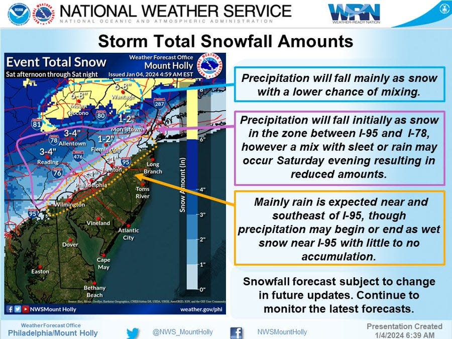
Snow is still likely above the line, with some areas forecast to get 3 or more inches and the Poconos expecting up to half-a-foot.
Despite the latest call, the NWS is still suggesting residents make preparations for any outcome this weekend, with the storm coming in Saturday evening and lasting through Sunday morning.
This is a developing story and will be updated.
Nick Butler is an impact reporter for the Courier Post, the Daily Journal and the Burlington County Times covering community news in South Jersey. Have any tips or stories? Reach out to NButler@Gannett.com. Subscribe to stay in the loop.
More: Miss the winter weather in South Jersey? We're keeping track of our 2024 snowstorms.
This article originally appeared on Cherry Hill Courier-Post: Will first winter storm of 2024 break two-year snow drought?

