'Get home and don’t leave': Parts of Oregon powerless amid ice storm: Live updates
While the vast majority of Americans grappling with freezing temperatures could find comfort inside heated homes and businesses, more than 50,000 were out of power Tuesday evening in Oregon, where half of the 14 deaths attributed to the arctic blast have occurred.
The Pacific Northwest in general was bracing for freezing rain and ice, but western Oregon was expecting the worst of it as the state's three largest cities − Portland, Salem and Eugene – were forecast to get up to half an inch of ice through early Wednesday before a reprieve later in the day.
Many of their residents will have to brave the frigid weather without heat after power in some areas was knocked out by a weekend storm and the harsh weather hindered restoration efforts. Though smaller blackouts have hit other parts of the country, no other state has as many as 10,000 electric customers in the dark, according to poweroutage.us.
More outages may happen, according to electricity provider Portland General Electric and the National Weather Service, which posted a warning saying: “Power outages and tree damage are likely due to the ice. Travel could be difficult.”
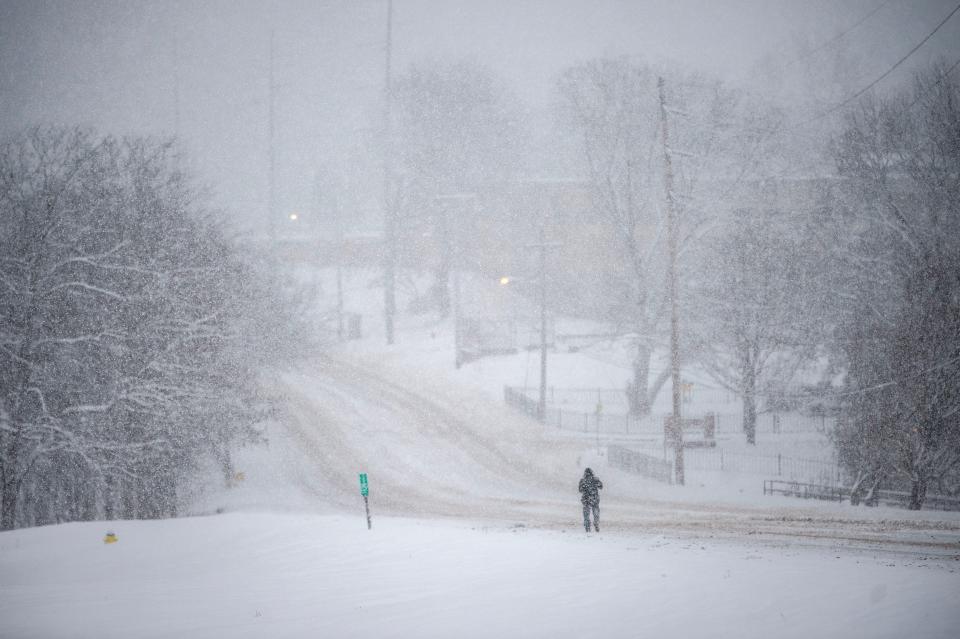
A 47-mile stretch of Interstate 84, which connects Portland with the Columbia River Gorge, was closed in anticipation of the icy conditions, and residents have been encouraged not to venture out even on foot because of slick sidewalks.
That message was clearly stated by the lead headline on the website of the Portland Oregonian newspaper, which said, "Get home and don’t leave: Ice storm arrives in Portland.''
150M under weather alerts: 'Dangerous cold' has US in its clutches
Developments:
∎ Among the 14 deaths linked to the weather over the last few days, five people in Oregon died of hypothermia and two were killed by falling trees. A snowmobiler was hit by a truck in Utah, a skier was killed by an avalanche in Wyoming and three people died of suspected hypothermia in Wisconsin. In New Jersey's slippery Garden State Parkway, two people died Tuesday when their SUV collided with a snowplow.
∎ More than 10,500 flights had been delayed or canceled as of 8 p.m. ET. More than 36,000 such disruptions were reported Saturday through Monday, a high-travel weekend because of the Martin Luther King holiday.
∎ Classes were canceled for millions of students from Portland to Chicago to Denver to Dallas to Baltimore. Many schools already canceled classes for Wednesday as well.
∎ Authorities in Texas and the Tennessee Valley area asked residents to voluntarily cut back on electricity use to avoid blackouts caused by high demand.
∎ In Kentucky, Powell County Search and Rescue led a team that extricated four hikers trapped in the Red River Gorge, calling it "one of the most dangerous rescues ever attempted in the Gorge."
About 3/4 of the US in a deep freeze
Millions of gleeful students were kept out of schools, travel was chaotic and the federal government shuttered offices around the nation’s capital Tuesday as a wall of bitter cold temperatures, ice and snow descended on a broad expanse of the country.
The sweeping mass of arctic air crashing down from Canada was forecast to deliver subfreezing temperatures to three-fourths of the nation, and 68 million Americans were under a winter weather advisory Tuesday. New York, Philadelphia, Baltimore and Washington, D.C., saw an end to snow droughts that lasted almost two years.
“Once again, winter weather headlines dominate much of the weather story,” National Weather Service meteorologist Jacob Asherman said. Part of that story is the death toll from the cold front, now at 14 after five more fatalities were reported Tuesday.
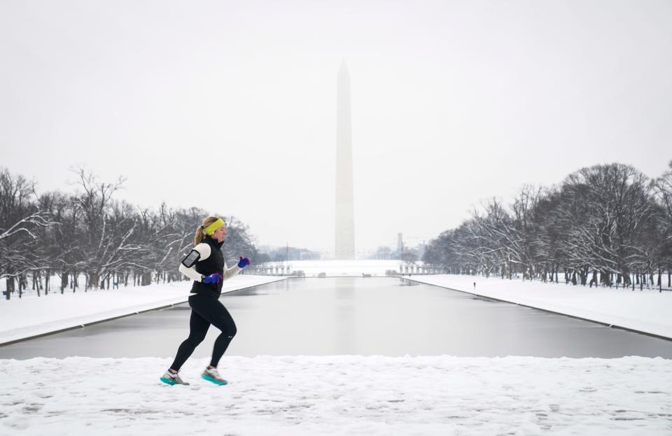
About 4 inches of snow fell in the Washington, D.C., area, closing many businesses, offices and schools. The snow was finished, but the deep freeze was just beginning − the temperature wasn’t forecast to rise above freezing until Thursday. By Friday another system could mean another deep freeze lasting through the weekend.
In suburban Virginia, Mark Hyatt, 47, went for a 3-mile run before shoveling out two cars and the steps to his Arlington home. Hyatt, a defense contractor, was working from home because his office was closed. He was not complaining.
“I think its wonderful to have snow here after two years,” Hyatt said. “I hope they have some on the ski slopes. It’s been tough − global warming is a real thing.”
Nashville gets more snow in a day than in a typical year
In Tennessee, almost two dozen abandoned cars lined the steep, icy entry to a Nashville apartment complex. The area averaged 4.7 inches of snow a year from 1991 to 2020, but this storm dumped 8 inches on the National Weather Service office. And it won't melt soon − the temperature isn't forecast to rise above freezing until Thursday afternoon.
Elijah Clark shouldered his backpack as he left his Honda Civic in the middle of the road. Clark said he had driven to a friend's house to drop off a guitar.
"We're stuck-stuck," he told The Tennessean, part of the USA TODAY Network. "I came back hoping I could make it up the hill − front wheel drive and all that − and it did not work out. It did not work out at all."
− Keith Sharon, Evan Mealins and Angele Latham, Nashville Tennessean
More record-breaking cold for much of the nation
A similar narrative is playing out across much of the nation. Asherman cited areas of wintry precipitation along the Atlantic and Pacific coasts and said frigid Arctic air is "sandwiched" over the central and southern U.S. After producing widespread snow, sleet and freezing rain over the Deep South on Monday, the fast-moving system spread moderate to heavy snowfall into the mid-Atlantic Tuesday morning.
The Pacific Northwest faced "significant" freezing rain as well. Portions of the Cascades into the Northern Rockies could see 15-28 inches of snow, Asherman said. And another day of record-breaking cold was expected across much of the Rockies, Great Plains and Midwest, he said. Wind chills below minus 30 could extend as far south as the Mississippi Valley, Asherman said.
A reprieve is expected Wednesday, but another surge of arctic air is forecast to sweep across the Plains and Deep South by Thursday or Friday.
Northeast snow drought comes to an end
Philadelphia saw more than an inch of snow for the first time in 715 days. Baltimore's 1.4 inches snapped a streak of 716 days. Washington, D.C., ended its 1-inch streak of 728 days.
"It's official! Over 1" of snow so far in DC & Baltimore, first time in approx. two years we've had this much snow!" the weather service office serving the cities said in a social media post.
Washington DC Snowball Fight Association ( Yes, it’s official)
held a early morning Battle of Snowpenheimer snowball fight at the national mall. A few locals came out to participate. pic.twitter.com/jTfiQtCfhD— Washington Informer (@WashInformer) January 16, 2024
New York's Central Park drew more than 1 inch of snow for the first time in 701 days.
"The streak has ended!" the weather service in New York City said in a post.
Looking ahead, more of the same
For those looking forward to a midweek warming, enjoy it while you can. It will be brief.
Next weekend's weather forecast has the makings of another arctic blast hitting much of the country, though not as powerfully as the one still causing shivers to most Americans. The central and eastern U.S. are expected to bear the brunt of this next cold front, particularly Friday and Saturday.
"While temperatures are forecast to be generally 15-30F below average, this second round of cold temperatures should be less extreme than the current cold wave at most locations,'' the Weather Prediction Center says.
The low temperatures and expected precipitation mean snow will accumulate in cities like Chicago, St. Louis, Washington, D.C., and New York, AccuWeather reports, adding that some locations could get blanketed by several inches starting as early as Thursday night for the Midwest cities.
More snow in store for Buffalo, but residents ready to help
The Buffalo area, where they measure the snowfall in inches per hour instead of per day, received 1 to 3 feet of snow overnight after another 3 feet on the weekend forced the NFL Bills' playoff game to be delayed by a day.
Images of Buffalo residents clearing snow from the seats before Monday evening's playoff game at Highmark Stadium revealed the city's passion for the team, which may call on fans to help them again Sunday when the Bills host the Kansas City Chiefs. There's snow in the forecast most of the week before a partial clearing Sunday.
"Lake effect snow off Lake Erie is shifting southward this afternoon,'' the National Weather Service office in Buffalo said in a social media post. "Snowfall rates of 1-2" per hour will be possible.''
A foot or more of fresh snow is forecast through Thursday, providing plenty of opportunities for the 14-year-old who came to Belinda Bonacquisti's aid to work his snowblower magic. She had only a shovel to remove 3 feet of snow from her suburban Buffalo driveway when he showed up Monday.
“I didn’t know where he came from or what direction,” she told WKBW-TV. “He just really bailed me out.”
Contributing: The Associated Press
This article originally appeared on USA TODAY: Winter storm updates: Oregon powerless amid ice storm; 14 dead in US

