Storm prompts San Bernardino County officials to declare state of emergency
San Bernardino County officials declared a state of emergency late Sunday in anticipation of extreme rain and snow.
They also announced an evacuation warning for portions of the San Bernardino Mountains due to potential mud and debris flows.
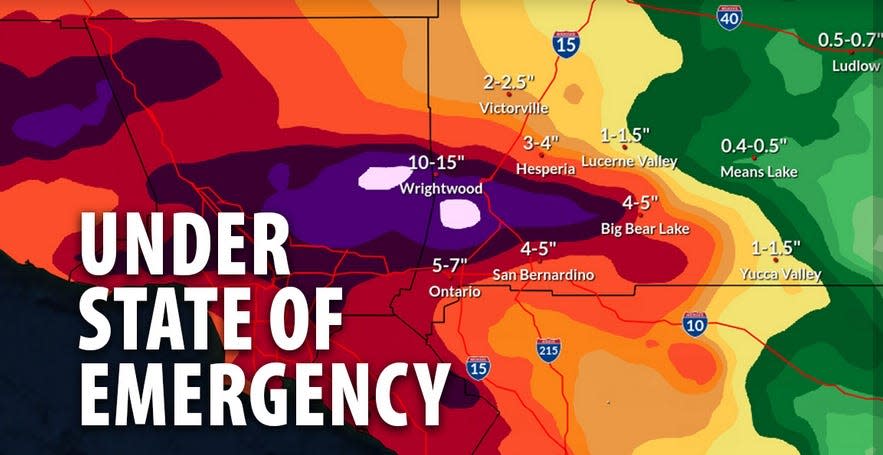
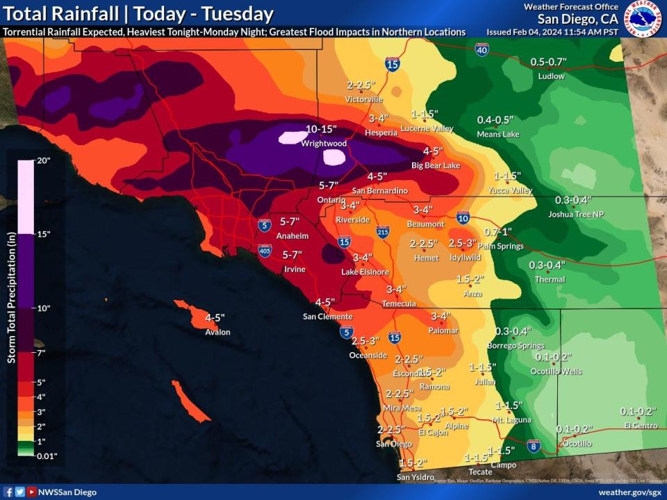
The San Bernardino County Sheriff’s Department reported that Forest Falls and Angelus Oaks communities are now under evacuation warning. Parts of the San Bernardino Mountains are expected to be pummeled with 7 to 20 inches of rain through Tuesday, according to the weather service.
https://t.co/x1kr3VK2qY pic.twitter.com/32xN6W4nE8
— FirePhotoGirl (@FirePhotoGirl) February 5, 2024
Swift water rescue
At 11:55 p.m. on Sunday, the Daily Press reported that San Bernardino County Fire Department officials responded to the report of a water rescue on Keenbrook Road west of Cajon Boulevard.
Fire officials stated that a vehicle with three occupants attempted to cross the flooded roadway.
First responders arrived to find the occupants stranded in a tree while their vehicle was submerged in rapid flood waters.
At about 12:31 a.m. The fire department's rescue team was set up Monday to retrieve the three people.
Local snowfall
In the San Bernardino Mountains, heavy snow fell from Sunday to Monday morning, beginning above 7,000 feet and then dropping to the 6,000-foot level.
Caltrans District 8 reported that chain control is already present on Highway 18 from Stanfield Cutoff in Big Bear to the northwest of Running Springs.
Travelers should expect chain control throughout the mountain communities during and after the storm.
Evac warning due to potential mud and debris flow for El Dorado and Apple fire burn scars.
Be prepared and stay safe.
⁃Your Yucaipa PD#YucaipaPD #Weatheralert #Staysafe #Beprepared #EvacuationWarning pic.twitter.com/JIafbYPOSR— Yucaipa Police (@YucaipaPD) February 5, 2024
Be prepared to evacuate
Mountain residents in the affected areas should monitor county-associated social media pages for updates on flooding and evacuations, county officials stated on Sunday.
Residents should be prepared to leave or not be able to return home due to the evacuation order.
Residents should have a go-bag ready with important medication documents, clothing, and other supplies.
Pet owners should also prepare a go-bag for their animals, county officials said.
On Sunday, Governor Gavin Newson declared a state of emergency for Los Angeles, Orange, Riverside, San Bernardino, San Diego, San Luis Obispo, Santa Barbara, and Ventura counties.
Powerful storm
Last week, weather experts sounded the alarm as they expected a powerful, slow-moving, atmospheric river-fueled storm to roll through Southern California, including the High Desert, over the weekend.
The weather service “predicted catastrophic and life-threatening flooding” for the San Bernardino Valley and coastal slopes of the San Bernardino Mountains on Sunday through Tuesday, with the chance of showers through Friday, county officials said.
The oncoming storm could make travel and commuting difficult and could cause urban flooding and small streams and rivers to rise, according to the county.
During the storm, residents in the mountain areas should expect strong winds. At 6:10 p.m. on Sunday, a 92 mph wind gust was recorded east of the Cajon Pass, the National Weather Service reported.
Heavy rain, reduced visibility, and strong winds were reported Sunday night in the San Bernardino Mountains.

High Desert
In the High Desert, most rain will fall through Tuesday.
The National Weather Service forecasts that the storm will bring up to 4 inches of rain to the High Desert, with heavier rainfall in places like the Cajon Pass and portions of Hesperia.
A flood watch will be in effect in southwest California, including Apple Valley, Lucerne Valley, Hesperia, and the San Bernardino Mountains.
State of emergency
The county’s emergency declaration puts the state and federal government on notice that San Bernardino County residents will need their help, said Board of Supervisors Chair and Third District Supervisor Dawn Rowe in a written statement.
“The county is taking all available steps to keep our residents safe, and we are making preparations to meet their needs during and after the storms,” Rowe said. “I urge everyone to take necessary precautions, avoid unnecessary travel, and visit Prepare.SBCounty.gov for vital safety information.”
The county sent out phone and text warnings in English and Spanish, warning residents about the potential for flooding and mudslides. The county will continue to post notices and safety information on its social media platforms.
The county has crews and equipment in position to be activated as needed.
The county’s emergency declaration clears the way for state and federal assistance that will likely be needed to assist the county in coping with the storms and their aftermath.
The proclamation, which San Bernardino County CEO Luther Snoke signed as the county's director of emergency services, will be submitted to the County Board of Supervisors for ratification.
Governor’s response
The state’s emergency proclamation includes provisions authorizing a California National Guard response if tasked, facilitating unemployment benefits for impacted residents, and making it easier for out-of-state contractors and utilities to repair storm damage.
These are the five things you can do to stay safer, as suggested by state officials:
Stay connected. Dial 311 to get help or ask questions. If you have a critical emergency, call 911. Stay informed by signing up for emergency alerts, including warnings and evacuation notices, at CalAlerts.org.
Get your information from trusted sources. Check state and local government or emergency management websites and social media accounts for trusted information about your area. Local news outlets and meteorologists are also a good source of information. Be wary of posts from unknown sources on social platforms or from online ‘experts’ without credentials.
Prepare for high winds. Before a high wind event: remove any dead trees or overhanging branches near structures, remove loose roofing material, bring in unsecured objects from patios and balconies, secure outdoor objects that could blow away, shutter windows securely, and brace outside doors. During a high wind event, take cover next to a building or under shelter, stay away from windows, stay clear of roadways and train tracks, avoid elevated areas such as roofs, and watch for flying debris.
Travel safely. Avoid non-essential travel during the peak of the storm expected on Sunday and Monday. If you must drive, download the QuickMap app or visit QuickMap (ca.gov) to learn up-to-the-minute information on road conditions, traffic, closures, and more. Do not walk, swim, or drive through flood waters. Turn Around, Don’t Drown! Remember, just six inches of moving water can knock you down, and one foot of moving water can sweep your vehicle away.
Be ready in case of power outages. Take inventory of the items you need that rely on electricity. Keep your devices charged. Plan for batteries and other alternative power sources to meet your needs if the power goes out, such as a portable charger or power bank. Have flashlights for every household member.

Rain expected to begin Monday morning in Palm Springs area
Most of the Coachella Valley was expected to get heavy rain all day Monday, according to Adam Roser, a meteorologist with the National Weather Service in San Diego.
The storm is forecasted to expand across the valley overnight heading into Tuesday, with a half-inch to three-quarters of an inch of rain expected in the western Coachella Valley and a quarter to a third of an inch forecasted in the eastern parts of the valley through Tuesday night, according to Roser, who warned of potential flash flooding later Monday.
More snowfall is expected in the surrounding mountains later Monday heading into Tuesday, with most of the snow falling at elevations over 7,000 feet. As of 4:30 a.m. Monday, the National Weather Service had recorded just over three-quarters of an inch of precipitation at its station near Idyllwild over the last 24 hours, with more on the way.
Another smaller storm system could move through the area on Thursday or Friday, potentially bringing another 0.10 inches of rain in Palm Springs, according to Roser.

Storm affects other parts of California
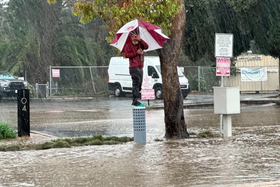
Sunday’s storm flooded roadways, and knocked out power to nearly 850,000 people, and prompted a rare warning for hurricane-force winds, the Associated Press reported.
The storm flooded streets and brought down trees and electrical lines across the San Francisco Bay Area, where winds topped 60 mph in some areas. Gusts exceeding 80 mph were recorded in the mountains.
The National Weather Service office for Los Angeles warned that “all systems are go" for one of the most dramatic weather days in recent memory.”
On Sunday, customers called the Santa Barbara Home Improvement Center inquiring about sandbags and flashlights. and generators said assistant manager Lupita Vital. Sandbags sold out on Saturday, so people were buying bags of potting soil and fertilizer instead, she said.
More than 847,000 customers were without electricity statewide by Sunday evening, with most of the outages concentrated in coastal regions, according to poweroutage.us.
“This is a dangerous system with major risks to life and property,” the weather service’s LA-area office said. “Residents should heed any evacuation orders. Stay off the roads, especially the freeways, this afternoon through at least Monday morning.”
The Associated Press and the USA TODAY Network- California contributed to this story.
Daily Press reporter Rene Ray De La Cruz may be reached at 760-951-6227 or RDeLaCruz@VVDailyPress.com. Follow him on Twitter @DP_ReneDeLaCruz
This article originally appeared on Victorville Daily Press: Storm prompts state, county officials to declare state of emergency

