Winter storm warning: Snow, dangerous wind chills and hazardous driving expected in Akron area
Friday weather update: Up to 7 inches of snow now expected in the area; schools cancel
The big one is coming.
Northern Ohio has been spared the brunt of winter storms so far this winter, but forecasters say our luck appears to have run out.
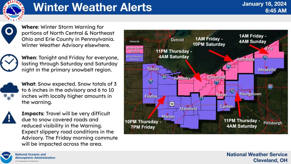
Winter storm warning starts Thursday night
The National Weather Service has issued a winter storm warning for Medina, Summit, Lorain, Cuyahoga, Erie and Huron counties from 11 p.m. Thursday through 4 a.m. Saturday.
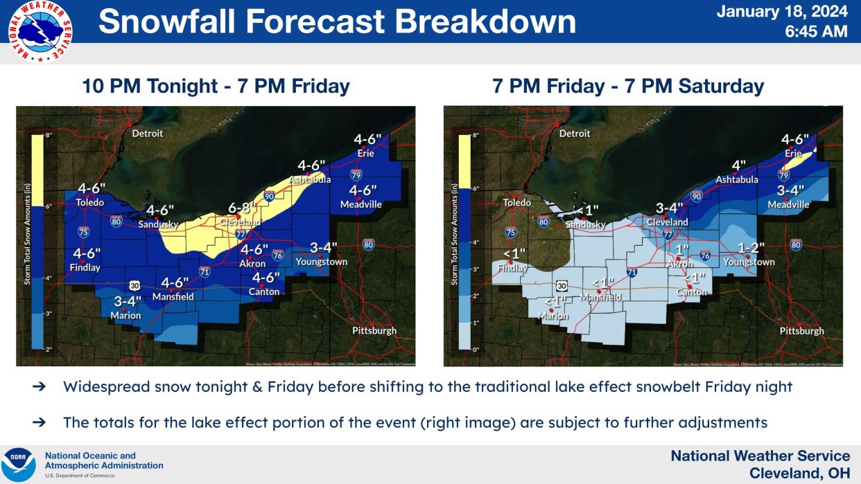
How much snow is Akron going to get?
Heavy snow is expected with anywhere from 5 to 9 inches expected to fall across the region.
Akron road conditions
"Travel could be very difficult," the weather service warns. "The hazardous conditions could impact the (Friday) morning and evening commute."
The widespread snow will start Thursday night and eventually transition to lake effect-enhanced snow by Friday afternoon.
What will the wind chill be like?
The wind will be a problem too with gusts as high as 30 mph.
Wind chills as low as 5 to 15 degrees below zero are expected.
"If you must travel, keep an extra flashlight, food, and water in your vehicle in case of an emergency," the weather service advises.
Winter weather advisory for other northern Ohio counties
Other northern Ohio counties including Portage, Stark, Wayne, Ashland and Richland counties are under a winter weather advisory with anywhere from 3 to 6 inches of snow possible.
Akron warming centers
To help residents cope with the cold temperatures, Akron plans to offer places for residents keep warm.
The Summit Lake Community Center at 380 W. Crosier St. is open as a warming center 8 a.m. to 7 p.m. through Friday. Summit Lake Community Center will be unavailable as a warming center Saturday due to a number of private events scheduled there.
On Saturday, the City of Akron is extending hours at Mason Park Community Center (700 E. Exchange St.) to serve as a warming center from 8 a.m.-7p.m.
All other City of Akron community centers will be open during their normal business hours.
Unless otherwise specified, all centers will return to normal business hours starting Sunday, January 21.
The Emergency Overnight Shelter at 111 East Voris St. will be open 7 p.m. to 8 a.m. through Monday. The shelter is a community partnership between The Peter Maurin Center, Summit County Continuum of Care, and Community Support Services and provides food, shelter, and clothing. You can find more information about their services at https://www.akronemergencyshelter.org/.
What's the forecast?
Thursday: A slight chance of snow showers before 9 a.m., then a chance of snow showers after 11 a.m. Cloudy, with a high near 27. Southwest wind 9 to 11 mph. Chance of precipitation is 30 percent. Total daytime snow accumulation of less than a half inch possible.
Thursday night: Snow, mainly after 11 p.m. Low around 21. South wind around 5 mph becoming calm in the evening. Chance of precipitation is 100 percent. New snow accumulation of 1 to 2 inches possible.
Friday: Snow before noon, then snow showers after noon. High near 26. Light northwest wind increasing to 8 to 13 mph in the morning. Chance of precipitation is 100 percent. New snow accumulation of 2 to 4 inches possible.
Friday night: Snow showers likely, mainly before 1 a.m. Cloudy, with a low around 8. Wind chill values as low as -3. West wind 11 to 14 mph. Chance of precipitation is 70 percent. New snow accumulation of less than one inch possible.
Saturday: A chance of snow showers, mainly before 1 p.m. Mostly cloudy, with a high near 16. West wind 11 to 15 mph. Chance of precipitation is 30 percent. New snow accumulation of less than a half inch possible.
Saturday night: A chance of snow showers, mainly before 1 a.m. Mostly cloudy, with a low around 12. Chance of precipitation is 40 percent. New snow accumulation of less than a half inch possible.
Sunday: Partly sunny, with a high near 24.
Sunday night: Partly cloudy, with a low around 12.
Monday: Mostly cloudy, with a high near 34.
Monday night: A chance of snow showers after 1 a.m. Cloudy, with a low around 28. Chance of precipitation is 30 percent.
Tuesday: A chance of showers. Cloudy, with a high near 39. Chance of precipitation is 50 percent.
Tuesday night: A chance of showers. Cloudy, with a low around 35. Chance of precipitation is 50 percent.
Wednesday: A chance of showers. Cloudy, with a high near 45. Chance of precipitation is 50 percent.
Check Akron weather hourly
Need to know weather conditions by the hour? Make sure to check out our weather page here.
This article originally appeared on Akron Beacon Journal: Winter storm warning for Summit County Thursday night into Saturday

