Colorado releases map showing movements of state's 12 collared wolves
Colorado Parks and Wildlife unveiled for the first time Wednesday a map and website to help identify the general locations of where the state's 10 recently released wolves and two North Park pack members have been located.
The state wildlife agency released the website and map just weeks after hearing complaints from the public about wanting to know the whereabouts of the wolves. Those complaints came after the wolves captured in Oregon were released in Grand and Summit counties in late December.
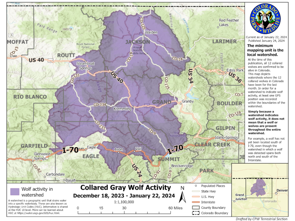
As of Jan. 22, all 12 collared wolves were alive and in Colorado and there have been no reported depredations by the released wolves, according to Colorado Parks and Wildlife.
How the mapping of Colorado's wolves will be shared
The maps will show where wolves have been in the past month. Currently, the map shows wolf tracking from Dec. 18, 2023, the initial release date, to Jan. 22, 2024.
The map will be updated with new information on the fourth Wednesday of every month and will reflect data for the prior month.
How the GPS collars work and how often signals are received
Currently, the collars are programmed to record a position every four hours.
Once four locations have been recorded, the four locations are transmitted via satellite to Colorado Parks and Wildlife biologists.
The frequency of both position recording and transmission of the data can be delayed by a number of factors such as dense cloud cover, closed terrain, etc.
The data allows Colorado Parks and Wildlife staff to learn where wolves have been.
It is important to note the signals cannot indicate where wolves are at a current point in time, nor can they predict where the wolves will go.
To protect the wolves, specific GPS data will not be shared.
What you will see on the map to track the wolves' movements
The map is broken down into watersheds where the 12 collared wolves in Colorado have been for the last month.
Watersheds were used for mapping because wolves are far more likely to use geographic features to affect their movement than political boundaries.
The watershed maps provide detailed information that can help agricultural producers be informed of the general areas where wolf activity is known to exist without being too general while also not being specific enough to risk the protection of individual wolves.
In order for a watershed to indicate wolf activity, at least one GPS point from a wolf's collar was recorded within the boundaries of the watershed.
Simply because a watershed indicates wolf activity, it does not mean that a wolf or wolves are present throughout the entire watershed nor that they may currently be in the watershed, as wolves tend to wander widely.
Colorado Parks and Wildlife reserves the right to buffer maps shared with the public if doing so protects wolf welfare during sensitive times of the year such as mating season.
How to report a wolf sighting to Colorado Parks and Wildlife
The state wildlife agency asks the public to report possible wolf sightings to https://cpw.state.co.us/learn/Pages/Wolf-Sighting-Form.aspx.
It is beneficial to include video and/or photographs as well as location, time and date of the sighting.
Some photos of the released wolves have been captured by the public.
Resources to help you live with and know more about Colorado's wolves
Colorado Parks and Wildlife has created a hands-on resource guide to help reduce wolf depredations on livestock. Visit cpw.state.co.us to access the guide.
Colorado Parks and Wildlife also has created a brochure on how to avoid conflicts with wolves and what to do should you encounter them while recreating.
This article originally appeared on Fort Collins Coloradoan: Where are Colorado wolves? How to use Colorado Parks and Wildlife map

