How much snow will we get? Here are the latest projections for this weekend's winter storm
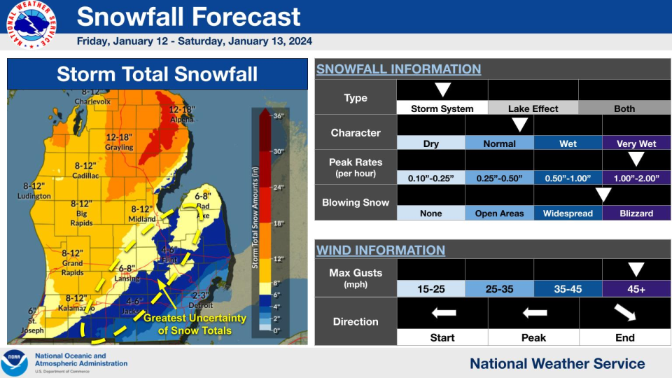
LANSING — Residents are preparing for snowfall Friday afternoon into Saturday, and weekend totals are expected to vary between 6-8 inches in Ingham County and 8-12 inches north into Clinton County.
Weather
Embedded content: https://www.weather.gov/images/grr/wxstory/Tab2FileL.png?86f0c61edd39bbafdffa849c28a7b90a
The National Weather Service in Grand Rapids is expecting the heaviest snowfall from 1 p.m. to 7 p.m. Friday, although a winter storm warning is in effect from 10 a.m. Friday to 7 p.m. Saturday.
Meteorologists advise drivers to stay off the roads Friday afternoon, due to poor visibility, snow covered roads and blowing and drifting snow.
It will be worse to the north. Many areas in the northern Lower Peninsula are in the 8-12 inch projections, and it will be worse in some areas of the Upper Peninsula. Grand Marais on the shores of Lake Superior in the central UP and Ishpeming in the western UP are expected to get 18-24 inches of snow.
Here are snowfall totals for the Lansing area and surrounding communities within about an hour's drive.
Snowfall predictions
Alma: 9-13 inches
Ann Arbor: 4-6 inches
Clare: 11-15 inches
Detroit: 1-2 inches
Flint: 4-8 inches
Grand Rapids: 10-14 inches
Howell: 5-8 inches
Jackson: 5-8 inches
Lansing: 6-8 inches
Midland: 8-11 inches
Mount Pleasant: 8-12 inches
Owosso: 5 inches
Saginaw: 5-8 inches
More: Michigan power outage maps: How to check your status in the Lansing area
More: Storm update: Latest forecast says 'snow could be heavy' on Friday
This article originally appeared on Lansing State Journal: How much snow will we get? Here are the latest projections


