How much snow will the South Shore get during this weekend's winter storm?

QUINCY – The South Shore is bracing for what will be the first snowfall of the season, though areas inland will likely take the brunt of the storm this weekend.
Meteorologists project that the storm will move into the area on Saturday night and continue through some of the day Sunday, though they aren't exactly sure how much snow it will bring.
"As the storm pushes northward Saturday night into Sunday, the storm is bumping into some colder air that will be here in New England," WCVB StormTeam 5 chief meteorologist Cindy Fitzgibbon said. "By 5 a.m. on Sunday, it will be snowing across much of our area, and there will be some rain, some mixing in Southeastern Massachusetts and along the coast."
Fitzgibbon predicts that areas west of Route 128 are more likely to see significant snowfall, while the coast could see a mix of snow and rain resulting in less than 6 inches.
More: What to know about parking when Quincy declares a snow emergency

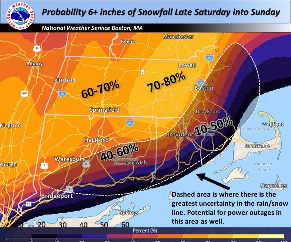
The National Weather Service says the areas to the south and east of Interstate 95 have less than a 40% chance of that getting six inches of snow due to warmer temperatures that will increase the likelihood of rain.
"The other concern in the forecast is the gusty winds across the coastal plain and perhaps into portions of the interior," according to The National Weather Service.
Where in Massachusetts is expected to really get hit?
The National Weather Service says the area northwest of Interstate 95 has the the highest probability of 6 or more inches of snow, at 40% to 70%.
Cities and towns near the highway, where rain could mix with snow, face the greatest chances of power problems, the weather service says in its forecast discussion Thursday.
"This will also be the location where heavy, wet snow falls somewhere and coupled with strong winds, we could have potential power outages," the weather service says.
Meteorologist Kyle Pederson, of the National Weather Service in Norton, said meteorologists are still determining where the rain/snow lines will occur within the state, though he said he thought now that coastal areas will not get as much snow.
Another National Weather Service meteorologist, Rob Megina, told the Telegram & Gazette of Worcester that forecasters will have more confidence "when we get to the end of the week.”
Will there be power outages?
According to The National Weather Service, areas southeast of Interstate 95, such as the South Shore, should be prepared for potential electrical outages.
"This will also be the location where heavy wet snow falls somewhere and coupled with strong winds we could have potential power outages," the service says.
A storm the week before Christmas hit the South Shore hard. The high-wind storm killed a Hingham man and caused widespread damage to properties. More than 99% of Scituate customers were without power at one point. They were among the 190,617 Massachusetts households without power.
Scituate readies for storm, offers residents an inside look
Given the impact of the wind storm, the town of Scituate created a video through Scituate Community TV that has been shared to Facebook and YouTube giving residents a primer on how the town prepares its roadways for snow.
“Much of what we do (to prepare) is pre-treat,” said Scituate DPW Direct Kevin Cafferty, who appears in and narrates the video.
A salt and brine mixture will be applied to the roads Saturday, which helps break up the snow and ice as it falls.
“It increases the meltability of the snow itself,” he said. “As well as making the salt stickier, it applies to the ground better and stays a lot longer.”
He explained that a second approach is to mix the rock salt in the town’s salt barn with molasses and other materials that allows the salt to be used on the roads at temperatures lower than what the untreated salt would allow after the snow falls.
“It allows us to get a cleaner cut when we plow the road,” he said.
Cafferty stressed the importance of not moving snow from driveways into the roadways, whether from homeowners or hired snow removers.
“It causes a lot of problems,” he said. “It can cause an accident.”
He added there are also fines for doing so.
The town, he added, is always looking for additional help with snowplowing.
Anyone interested in working with the town in plowing during and after Sunday can call 781-545-8732.
High wind gust in Milton: 90 mph set a new record
A new official peak gust for the date was set at 11:33 a.m. Monday, Dec. 18.
The prior record for peak gust for the date was 76 mph and was set in 1978.
Emergency numbers to know
To report a downed power line, medical, fire or other emergencies, dial 911.
Eversource: 800-592-2000
National Grid: 800-465-1212
Verizon: 800-VERIZON
Comcast: 800-XFINITY
This article originally appeared on The Patriot Ledger: South Shore bracing for first snowfall of the season this weekend

