Jan. 9 weather roundup: state of emergency; high rain, winds, flooding. What to know
ASHEVILLE — Buncombe County is now under a flash flood warning until 5 p.m. Jan. 9 for "life threatening flash flooding," as announced by the National Weather Service.
"At 12:11 p.m., emergency management reported flooding and swift water rescues in the Candler area," the alert said. "Between 2.5 and 4 inches of rain have fallen. ... Additional flooding remains possible on pretty much any tributary of the French Broad River, especially along Hominy Creek."
Heavy rain is increasing the risk of landslides, according to the NWS. The weather service advises the following:
Be especially alert if near a stream, especially at the base of a mountain or in a cove.
Watch for loose-moving soil and rocks or a sudden increase in streamflow.
Leave the area quickly if this is observed.
When driving along roads where the terrain is steep or rocky, watch and listen for falling rocks, mud, trees and other debris.
Heavy rain, very windy conditions and the threat of flooding will impact Western North Carolina through this evening, causing road closures and forcing some school districts to switch to remote learning for Jan. 9.
Gov. Roy Cooper signed an executive order Jan. 8 declaring a state of emergency ahead of the severe weather, waiving truck weight, size and hours of service restrictions so that vehicles carrying essential supplies can get their jobs done quickly, his office announced.
The Asheville Regional Airport has already received 1.45 inches by 7 a.m., according to meteorologist Jake Wimberley with the National Weather Service. Wimberley said the area could receive 1.5 to 2 inches through 7 p.m.
"A number of sites across the Southern mountains closer to the South Carolina border that are already at 2 to 3 inches of rain," Wimberly said. "Rain is going to continue through the morning and rainfall rates may still increase as thunderstorms move north into the area."
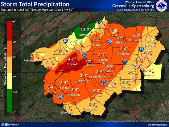
The NWS previously told the Citizen Times that Asheville will see an estimated 2.8 inches of precipitation from this storm system. To the south, in areas of Buncombe, Henderson, Haywood and Transylvania counties, there could be up to 6 inches of rain.
A flood watch is still in effect for all of the North Carolina mountains, except Madison, Swain and Graham counties, according to Wimberley. Flash flooding along small streams and minor or main stem river flooding is possible, according to the NWS.
A wind advisory has also been issued and extended across the North Carolina mountains from 10 p.m. Jan. 9 through 1 p.m. Jan. 10.
Near Asheville, the peak chance of thunderstorms Jan. 9 is between 9 a.m. and noon in Hendersonville and Brevard. But more "impactful" thunderstorms and the threat of severe weather is mostly going to be "upstate South Carolina and over toward Charlotte," Wimberley said.
The NWS is expecting a cold front to pass through with this weather system, and temperatures are expected to cool by this evening. Higher elevations near the Tennessee border should see precipitation change over to snow, with the highest peaks getting 2 to 3 inches, Wimberley said. However, Asheville is expected to stay too warm for any snow accumulation.
"One thing that has changed is the winter advisory that was in effect for some of the mountains has expired," Wimberley said, noting that the warning expired at 7 a.m. "There were some areas that got some ice accretion in the northern mountains, but temperatures are warming, they're already right at freezing and continuing to warm."
More info on storms Jan. 9: WNC 'dynamic storm system' will bring heavy rain, possible flooding to Asheville area
Closures and power outages
Some roads in the area have closed due to weather conditions, including the entire Blue Ridge Parkway for snow, ice and incoming weather, according to the park's website.
In the Great Smoky Mountains National Park, the following roads are closed due to downed trees: Newfound Gap Road, Laurel Creek Road, Cades Cove Loop Road, Foothills Parkway West (the new section), Cherokee Orchard Road, Greenbrier Road, Tremont Road, Lakeview Drive and Little River Road from Sugar Lands Visitor Center to Metcalf Bottoms.
West Chapel Road between Hendersonville Road and Sweeten Creek Road is closed both directions in Asheville until 5 p.m., according to DriveNC.gov. The following roads in and around Asheville are also closed, as of 3:45 p.m.:
Swannanoa River Road at Azalea Road
Hominy Creek Road at Shelburne Road
Meadow Road at Victoria Road
Iris Street at London Road
Caribou Street at Sweeten Creek
Riverside Drive at the Railroad Trestle
Druid Drive
The N.C. Department of Transportation has already seen multiple reported incidents on the roads, as announced on social media. If anyone must drive, N.C. DOT advises the following:
Slow down
Give following space
Never cross barricades
visit DriveNC.gov before you drive.
Because of flooding from Hominy Creek, the Buncombe County Transfer Station and County Garage will close at 3 p.m. Jan. 9, according to a news release from Buncombe County.
"The Buncombe Landfill at 85 Panther Branch Road is open on its regular schedule until 4:30 p.m. for waste and recycling needs," the release said. "Loads requiring more than 30 minutes to unload must be in the landfill by 4 p.m."
About 362 Duke Energy customers in Buncombe County are out of power as of 1:30 p.m. Jan. 9 due to downed lines and trees having fallen on lines and poles, according to spokesperson Madison McDonald. She said that most of these outages are scattered across the county and power will be restored between 4:30 p.m. and 7 p.m. tonight.
"We have crews actively out doing repairs," McDonald told the Citizen Times. "Our crews are going to continue work as long as it takes, and as long as it's safe to do so."
Schools switch to online learning
Buncombe County Schools and Asheville City Schools will have asynchronous remote learning Jan. 9 due to severe weather conditions, as announced in emails sent to staff.
Jan. 9 will also be an optional teacher workday for Buncombe County Schools. Teachers will upload assignments to their Learning Management System by 10 a.m. for students to work on at their own pace, the email said.
Assignments must be completed and turned in within five school days, according to the BCS announcement.
"Ten- and 11-month staff may work or use accrued leave by logging their absence in Red Rover," the email said. "12-month staff may work or take leave with supervisor permission. Staff who are able to complete their job functions from home may work remotely, with supervisor approval."
Full list of school delays, closings: School closings, delays in Western North Carolina for Jan. 9
City parks closed due to flooding
As severe weather continues to move through the area, some city parks have been closed due to flooding Jan. 9, including:
Amboy Riverfront Park
Azalea Park including the dog park
Carrier Park
French Broad River Park including the dog park
Jake Rusher Park
Jean Webb Park
John B. Lewis Soccer Complex
Weaver Park
BCS lunches
Certain Buncombe County schools will still provide lunch Jan. 9 between noon and 1 p.m.
"Families may come to one of the schools listed below with their students and join them in the cafeteria," the announcement said. "Adults are welcome to purchase a meal as well."
Schools serving lunch include:
North Windy Ridge Intermediate in the North Buncombe District
Estes Elementary School in the T.C. Roberson District
A.C. Reynolds Middle School in the A.C. Reynolds District
Black Mountain Primary in the Owen District
Sand Hill-Venable Elementary in the Enka District
Emma Elementary and Leicester Elementary in the Erwin District.
Ryley Ober is the Public Safety Reporter for Asheville Citizen Times, part of the USA Today Network. Email her at rober@gannett.com and follow her on Twitter @ryleyober
This article originally appeared on Asheville Citizen Times: WNC heavy rain, wind possible flooding expected Jan. 9