Nor'easter picking up along the South Shore. Here are the latest updates.
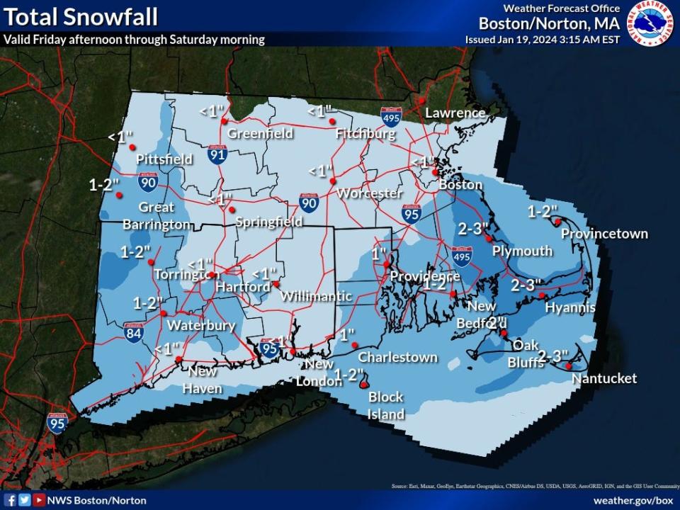
While much of the state woke up to far lower predicted snow totals from Tuesday’s nor’easter, residents from the South Shore to the Cape and Islands will still get several inches of snow, high winds and coastal flooding, according to the National Weather Service.
“Heavy, wet snow may lead to snow load issues, mainly across southern Rhode Island, Southeastern Massachusetts and Cape Cod, where some power outages are possible,” the latest update from the weather agency said.
Upper South Shore sees reduction in predicted accumulation
The storm was expected to begin overnight. Instead, much of the South Shore woke up to see it just starting.
The heaviest snow was expected to fall from 10 a.m. to 3 p.m., the weather service said.
A winter weather warning is in effect until 7 p.m. Tuesday for much of the state, including Norfolk and Plymouth counties, which the National Weather Service initially said could get snow totals from 4 to 8 inches.
The agency has since reduced those totals to 3 to 6 inches.
Plymouth and points south could be the hardest hit
Areas from Plymouth to the Cape and Islands are still in the storm's crosshairs, with snow totals of up to 9 inches possible and damaging winds that could exceed 50 mph, according to the National Weather Service.
Nor'easter will bring high winds
Wind gusts of up to 40 mph are expected along the South Shore, with damaging gusts of 50 mph or more expected for the South Coast and especially the Cape and Islands, the National Weather Service said.
The agency said the strongest winds will be late afternoon and early evening. The winds will coincide with an astronomical high tide that begins at about 2 p.m.
The storm is moving quickly and should be mostly over by late afternoon to early evening, according to the agency.
National Grid and Eversource power outages
As of noon Tuesday, National Grid's power outage map showed virtually no outages locally, with only Scituate reporting one affected customer in Scituate.
Eversource's map likewise showed few to no outages along the South Shore.
"Strong wind gusts and the accumulation of wet, heavy snow have the potential to damage trees and knock down power wires, causing power outages across the region," a press release from National Grid said.
“National Grid has been monitoring the forecasts closely for multiple days. We have secured additional crews and personnel across Massachusetts who are ready to respond as quickly and safely as possible to any impact this storm may bring,” Tanya Moniz-Witten, vice president for electric operations for New England, said in the release.
Tides could be some of the highest in years
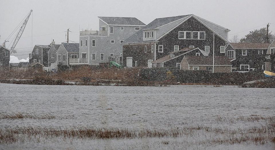
According to a report by WCVB, the nor'easter coupled with the afternoon's astronomical high tide could bring some of the highest tides to the area in six years. A coastal flood warning is in effect until 5 p.m.
In Quincy, Victory Road leading to Marina Bay is closed from East Squantum Street to the rotary due to flooding.
The afternoon high tide was expected to crest shortly before 2 p.m. at about 13.2 feet in Scituate.
Roads along the beach will flood, and so will part of the business district along Front Street, according to the town administrator.
“Our public safety has extra personnel on. We've pre-positioned our high-water vehicles. We have some down in Scituate Harbor. We have more down in Humarock. They're available if we have to go get someone in flood areas,” Scituate Town Manager Jim Boudreau told WCVB.

Watch out for icy roads Tuesday night
Temperatures are expected to drop as the evening progresses, which is likely to cause icy roads, state Department of Transportation Highway Administrator Jonathan Gulliver told WCVB.
"We're expecting a steep temperature drop after the snow stops. This is a wet, heavy snow, which means there's going to be some damp pavement out there. And that's something that's going to give us some concerns about icing," Gulliver said. "We're going to keep crews on for some time to just put down some final treatment to try to prevent that icing. But drivers that are out tonight should be cautious. It could get slippery out there."
Do I need to cancel my Valentine's Day plans?
While the snow will still be on the ground come Valentine's Day on Wednesday, the weather will be mostly sunny with a high near 33 and no further snowfall expected.
Quincy parking ban in effect
Quincy Emergency Management Direct Ally Sleiman noted that the astronomical high tides could lead to coastal flooding, specifically in the Squantum, Houghs Neck and Adams Shore neighborhoods.
Last month, the combination of heavy rain and astronomically high tides flooded coastal roads and neighborhoods, including Squantum, Marina Bay and Houghs Neck, leaving some drivers and passengers stranded.
Sleiman cautioned residents to avoid coastal roads between noon and 3 p.m., especially Marina Bay, East Squantum Street and the Newport Avenue Extension. High tide will occur at 1:45 p.m., Sleiman said.
A snow parking emergency went into effect Tuesday at 6 a.m., which prohibits parking on designated streets and emergency arteries.
How is the rest of Massachusetts expected to fare?
The high snow totals of up to a foot expected for much of the state Monday are no longer expected, as the track of the storm has moved farther south, according to the National Weather Service. Cape Cod and the Islands will likely get 2 to 8 inches and wind gusts of up to 60 mph.
Track the storm's impact: Severe weather alerts and warnings
The Cape is under a coastal flood warning, a winter storm watch and a high wind warning.
The South Coast area is expected to get 4 to 10 inches of snow and some flooding, the National Weather Service said.
What’s the difference between a winter storm watch and a warning?
A “watch” covers a broad region and is an advisory to start preparing for a storm in the coming days. A “warning” covers a smaller area and is a notice that storm activity is happening very soon.
More: Many Boston flights are canceled. Is your flight among them?
South Shore school cancellations
Schools that are closed Tuesday include:
Abington public schools
Archbishop Williams
Blue Hills Regional Vocational in Canton
Braintree public schools
Canton public schools
Cohasset public schools
Curry College in Milton
Eastern Nazarene College in Quincy
Fontbonne Academy in Milton
Granite Academy in Braintree
Hanover public schools
Hingham public schools
Hull public schools
Inly School in Plymouth
May Center in Randolph (staff still reports)
Milton Academy in Milton
Milton public schools
New England Academy in Marshfield
Norwell public schools
Notre Dame Academy in Hingham
Old Colony Vocational Technical in Plymouth
Pembroke public schools
Plymouth public schools
Quincy College - Quincy and Plymouth campuses
Quincy public schools
Randolph public schools
Rising Tide Charter in Plymouth
Rockland public schools
SELA: The International Private School in Norwell and Hingham
Sacred Heart schools in Kingston
Sharon public schools
South Shore Charter in Norwell
South Shore Christian Academy in Weymouth
Southeastern Regional Vocational Technical High School in Easton
Stoughton public schools
Thayer Academy in Braintree
Weymouth public schools
Whitman public schools
Whitman-Hanson Regional
Woodward School in Quincy
Stay informed: Online power outage tracker
How should I prepare for a snowstorm?
Make sure you have enough food, water and medication to last at least a few days, in case driving is difficult afterward.
Keep your cars full of gas to keep the fuel line from freezing.
Have enough rock salt or ice melter and some sand or non-clumping cat litter on hand to provide traction on your sidewalk or driveway.
Have an emergency kit with flashlights, batteries and extra blankets in case your house loses electricity.
When it comes time to shovel, go slowly and take frequent breaks. If you’re using a snowblower, always keep your hands and feet clear of the blades.
Make sure fire hydrants and furnace and clothes dryer vents are clear of snow.
Emergency numbers to know
To report a downed power line, medical, fire or other emergencies, dial 911.
Eversource: 800-592-2000
National Grid: 800-465-1212
Verizon: 800-VERIZON
Comcast: 800-XFINITY
This article originally appeared on The Patriot Ledger: Nor'easter expected to dump snow, cause flooding on South Shore

