Life-threatening flood threat as heavy rain and powerful winds clobber California
Editor's Note: This page is a summary of the California storm news for Sunday, Feb. 4. For the latest news on the storm please see our live updates file for Monday, Feb. 5.
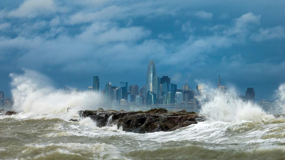
SAN FRANCISCO − A fierce winter storm fueled by a raging atmospheric river was thrashing Californians on Sunday with intense downpours, leaving hundreds of thousands without power, flooding roadways and prompting a rare warning of hurricane-force winds.
Up to 37 million people, about 94% of the state's population, were at risk for life-threatening floods from the storm, Accuweather meteorologists warned. The atmospheric river − like a river in the sky − is the second to pound the state in recent days, but forecasters said this storm would be the season's most potent, particularly in Southern California.
The National Weather Service issued a rare hurricane-force wind warning for the Central Coast: Wind gusts up to 92 mph were possible from the Monterey Peninsula to the northern section of San Luis Obispo County.
San Francisco officials sent out alerts about flooded and blocked streets, fallen trees − including a large one that brought down power lines − and a hillside landslide. About 100 miles down the coast in Monterey County, the final round of the AT&T Pebble Beach Pro-Am golf tournament was postponed until Monday, when weather conditions don't look favorable either.
The storm was expected to head south and hit the Los Angeles area with downpours, flash floods, and high-elevation mountain snow Sunday afternoon into the evening, then to pound Orange County and San Diego on Monday and Tuesday. Los Angeles and Orange were among eight Southern California counties were Gov. Gavin Newsom declared a state of emergency.
"All systems are go for one of the most dramatic weather days in recent memory," the National Weather Service said Sunday.
The first storm in the "Pineapple Express" soaked the state with 1-6 inches of rain Wednesday and Thursday. The new storm is laden with even more moisture, forecasters said, setting up dangerous and deadly conditions in already-saturated regions.

Latest developments:
∎ Winds exceeded 60 mph in some parts of the San Francisco Bay Area, with gusts above 80 mph in the mountains, strong enough to qualify for a Category 1 hurricane. Some areas received wind gust speeds of 98 mph and 102 mph.
∎ More than 856,00 homes and businesses were without power in California by 9:00 p.m. PST, the majority of them concentrated in coastal regions, according to poweroutage.us.
∎ Firefighters rescued a man stranded on an island in the Ventura River Sunday. The man was trapped with water rising around him, said Jeremy Henderson, a battalion chief with the Ventura City Fire Department. Someone reportedly heard the man screaming for help and called 911.
Local leaders warn residents to evacuate amid flood, mudslide risks
Evacuation warnings and orders were in effect for Santa Barbara, Los Angeles, Ventura, and Monterey counties.
Classes were canceled Monday for schools across Santa Barbara County. The Santa Barbara Airport closed Sunday evening due to flooding on the airfield, it said on its website.
“This storm is predicted to be one of the largest and most significant in our county’s history and our goal is to get through it without any fatalities or any serious injuries,” Santa Barbara County Sheriff Bill Brown said.
Los Angeles County Supervisor Lindsay Horvath urged residents near wildfire burn areas of Topanga and Soledad canyons to follow orders and evacuate ahead of possible mudslides.
“If you have not already left, please gather your family, your pets, your medications and leave immediately,” Horvath said at a Sunday briefing. The county set up shelters where evacuees could spend the night.
In San Diego, Mayor Todd Gloria said during a news conference Sunday that the storm "has the potential to drop a significant and unusual amount of rainfall on San Diego." He added that the city could receive between 2 to 2.5 inches of rain from Sunday night to Tuesday, with some areas possibly getting half an inch of rain per hour.
Gloria noted that the storm would be the city's third rain event in two weeks and reissued an evacuation order for low-lying and flood-prone areas within the city.
Meanwhile, Orange County issued an evacuation warning for Silverado Canyon, Williams Canyon and Trabuco Canyons due to heavy rains, and encouraged residents in the area to evacuate, especially those with disabilities, access or functional needs, and with large animals.
Desert communities on high alert
While the heaviest rains in the low and high California desert are expected late Monday through Tuesday, the surrounding mountains will be hit earlier, with heavy rain likely beginning Sunday night, and heavy snows expected Monday night.
About a quarter- to a half-inch of rain is expected in the western part of the Coachella Valley on Monday and a total of 1 to 1.5 inches through Tuesday. The east valley is forecast to get three-quarters of an inch of rain.
Mount San Jacinto is expected to receive up to 3 feet of snow and San Gorgonio a little more. Chances of rain lessen across the Coachella Valley by Wednesday but intermittent showers could occur through the end of the week.
Southern California schools brace for severe weather
The weather service forecast up to 8 inches of rainfall across Southern California’s coastal and valley areas, with 14 inches possible in the foothills and mountains.
Flash flood warnings were issued for the majority of Los Angeles County, including downtown and where the Grammy Awards are being held along with the east area, according to the weather service in Los Angeles. The alerts are in effect until 12 a.m. on Tuesday.
By 5 p.m. Sunday, the weather service said up to 1 inch of rain had fallen. "Additional rainfall amounts of 2 to 5 inches are possible in the warned area. Flash flooding is ongoing or expected to begin shortly," the weather service added.
In response to the dangerous conditions, some schools said Sunday that instruction would move to online classes.
"Out of an abundance of caution and with the safety of students, faculty and staff as its top priority, Cal State Fullerton will pivot to remote classes on Monday, Feb. 5, 2024. Staff are encouraged to work remotely," the university said in a statement.
California State University Long Beach also said campus operations would be modified due to the severe weather, adding that "in-person classes may shift to online instruction or alternative assignments, where possible."
As of Sunday afternoon, the Los Angeles Unified School District said it was planning to open schools as usual Monday. The decision would be reevaluated at 6 a.m. Monday, said Superintendent Alberto Carvalho.
Torrential rain could lead to flooding and mudslides
Heavy rain was expected from the San Francisco Bay Area and the Central Coast through Southern California on Sunday into Monday, the NOAA Weather Prediction Center said. Rainfall of 2-5 inches and up to 6-10 inches in some spots was likely, the prediction center said. “This will result in considerable flash, urban and small stream flooding with debris flows and mudslides,” the prediction center said.
The National Weather Service in Los Angeles warned Sunday that heavy rain would be moving into the area: 3-6 inches was expected for the coasts and valleys and up to 6-12 inches in the mountains.
“Due to the numerous mountains and hills, even just a few inches of rain can cause significant flooding,” AccuWeather Senior Director of Forecasting Operations Dan DePodwin said. “The greatest risk … is expected across the canyons and hills of Southern California, especially in Ventura, Santa Barbara, and Los Angeles counties.”
Storm's slow pace makes it more damaging
By lingering over large parts of California, the storm was drenching terrain that was already saturated from the atmospheric river-driven system that hit much of the state Wednesday and Thursday, increasing the chances of flooding.
“The core of the low pressure system is very deep, and it’s moving very slowly and it’s very close to us,'' said Ryan Kittell, a meteorologist at the National Weather Service’s Los Angeles-area office. "And that’s why we have those very strong winds. And the slow nature of it is really giving us the highest rainfall totals and the flooding risk.”
Heavy rain is expected in Southern California through Tuesday and there's a chance for showers through Friday, making mudslides and debris flows likely, forecasters say.
“Even if the rain does start to let up on Monday morning, just the sheer amount of rain overnight will cause lingering flooding issues into the morning hours,” Kittell said.
Three children ‘in the eye of the storm’ 400-plus miles away
Doug and Pam Barry were among more than 100,000 Californians without power when an outage hit their Miraloma Park neighborhood in San Francisco on Sunday morning.
That was far from their biggest concern, though. Their two sons are attending college in Los Angeles and San Diego, respectively, and their daughter Jessica was visiting the youngest son in San Diego when the storm hit. Now she’s hoping her plans to return Sunday to her home in Scottsdale, Arizona, don’t get disrupted.
“We have all three children in the eye of the storm in Southern California,” Doug Barry said. “We texted them yesterday to be careful with the approaching storm. We will get a good storm, but they will have it worse. Rarely do we share the same weather concerns with our children in California who are 400-plus miles away.”
Will harsh weather keep stars from arriving at Grammys?
Those sporting stylish outfits and elaborate hairdos at the Grammy Awards need not fear the wet and windy weather Sunday in Los Angeles, despite the downpour of biblical proportions expected early in the evening.
The infamous L.A. traffic? That may be another story.
The traditional red-carpet walk is being held under a roof and tarp outside the Crypto.com Arena in Downtown L.A., where nearly 5 inches of rain are forecast through Tuesday. The National Weather Service's L.A. office is warning of a "DANGEROUS SYSTEM with major risks to life and property. Substantial flooding.''
That's bound to make traffic even more of a nightmare than usual, even for the stars. Last year, headliners such as Beyonce and Bad Bunny arrived late after getting caught in traffic, and it wasn't raining.
Though the heaviest rainfall is not expected until 6 p.m. local time, an hour after the Grammys begin, the forecast calls for moderate rain from noon on, in addition to 30-50 mph winds in Los Angeles County.

Heavy snow, powerful winds could lead to whiteout conditions
Heavy, wet snow was expected to spread across the Sierra Nevada on Sunday through Tuesday morning, with snowfall of 2-3 inches per hour, the prediction center said. Wind gusts of up to 60 mph could lead to whiteout conditions in the Southern California mountains, forecasters said.
Palisades Tahoe, a ski resort about 200 miles northeast of San Francisco, said it was anticipating the heaviest snowfall yet this season, with accumulations of 6 inches per hour for a total of up to two feet.
HEAVY RAINFALL IS STILL IN THE FORECAST! Rainfall amounts 3-6 inches are expected for coasts and valleys up to 6-12 inches in the mountains. @NWSWPC has a moderate to high risk of excessive rainfall in effect for most of the area. #LARain #CAwx pic.twitter.com/DqT7CjtPcK
— NWS Los Angeles (@NWSLosAngeles) February 4, 2024
What is a Pineapple Express?
A Pineapple Express is the best-known nickname for an atmospheric river, which occurs when the source of the moisture is near Hawaii. When a Pineapple Express hits land in the western U.S. and Canada, it triggers heavy rain and snow. In California, it can lead to several inches of rain in a day.
Contributing: Doyle Rice, USA TODAY; Cheri Carlson, Ventura County Star; Kate Franco and Christopher Damien Palm Springs Desert Sun; The Associated Press
This article originally appeared on USA TODAY: Significant flooding threat as atmospheric river bulldozes California

