UPDATE: Ice forecast increases across Oregon Saturday morning as system stalls
Updated at 9 a.m. on Saturday, Jan. 13
The National Weather Service said the amount of ice expected in the Willamette Valley and the mountains has increased and is expected to last longer than previously forecast, bringing impacts to travel and utilities.
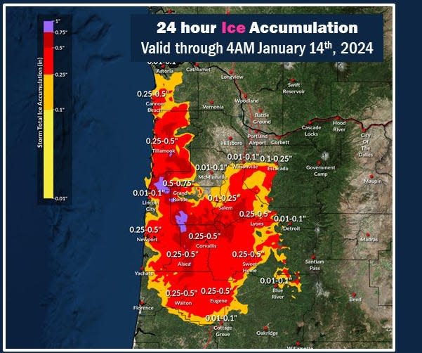
Updated totals shows between a quarter and half-inch of ice for a much larger area than expected, spanning from Newport on the Coast to Sweet Home in the Cascade Foothills all the way down to Eugene and north to Tillamook.
"The track of the storm slowed slightly, which means it's going to linger further into the evening and bring more precipitation that is falling either as sleet or as freezing rain," NWS meteorologist Tom Schuldt said. "That much ice will bring significant impacts to travel and everyday life.
"We're really asking people to stay off the road. It's very dangerous."
Schuldt said the freezing rain is expected to continue overnight and until 4 to 10 a.m. on Sunday before letting up. And even then, temperatures remain below freezing through Monday. It won't be until Tuesday that things start to melt out, he said.
For live updates on the winter storm including news on power outages, closures and road conditions, see this live updating story.
——
ORIGINAL STORY
A significant freezing rain event could cripple roads and knock out power between Salem and Eugene from late Friday night and into Saturday, according to the National Weather Service.
Upwards of a half-inch of ice could form, with the worst conditions currently projected for between Albany-Corvallis and Eugene.
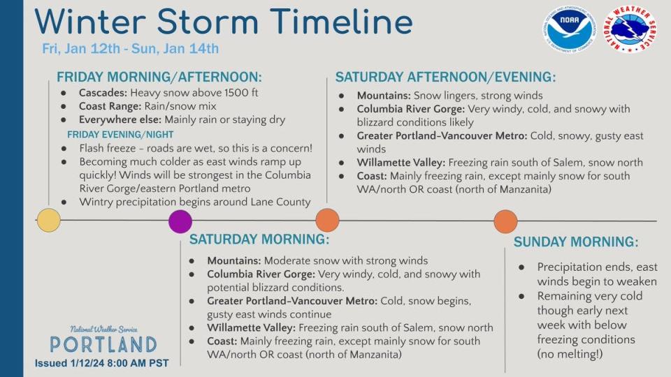
While some light freezing rain could fall by 5 p.m. Friday, the greatest concerns center on between 6 to 8 a.m. on Saturday morning.
“Saturday will not be a good time to be on the road,” National Weather Service meteorologist John Liu said. “We are projecting this as a more severe event.”
The line between Willamette Valley snow and freezing rain is right at Salem, Liu said. Given that, Salem could see a little more snow and a little less ice than areas to the south, but conditions are expected to be dangerous either way.
Temperatures stay frigid through the weekend and start to warm by Tuesday. Here's how to prepare.
Power companies prepare for outages
The two major power companies, PGE and Pacific Power, said they were preparing for outages. It’s unclear whether this system will bring power outages on the scale of the 2021 ice storm, when hundreds of thousands lost power for an extended period, but that level of impact is possible primarily on the south end of the Willamette Valley.
Will there be ice in the foothills?
Even in the Cascade Foothills outside of Salem and Eugene, freezing rain is considered more likely than snow even up to 1,000 feet in places such as Mill City, McKenzie Bridge and Lebanon. Roads into the Coast Range and toward the coast could be extremely slick.
How long will ice stick around?
The ice could last throughout the weekend, especially on roads not treated for ice, because temperatures are forecast to stay below freezing into Monday.
“On untreated roads, the ice could really stick around,” Liu said. “The high temperatures are only above freezing for maybe an hour on Sunday and Monday. That’s not a lot of time for the ice to melt. It will probably break up somewhat, but for any driving this weekend, you’ll want to be extremely careful especially off main roads.”
Snow forecast for Portland and north of Salem
Snow is forecast north of Salem, with about 1-3 inches of snow, and maybe more, forecast for the Portland metro area.
Columbia River Gorge could see 'blizzard-like' conditions
Extremely snowy, windy and difficult conditions are forecast for the Columbia River Gorge and Interstate 84.
Cascade Range passes snowstorm continues
Heavy snow, high winds and frigid temperatures continue at Cascade Range passes into Saturday.
The skies finally clear by Sunday and Monday.
Tips for planning for the ice storm from utilities
Utilities in the Willamette Valley suggest the following:
Prepare an outage kit that includes:
Flashlight or headlamps
Battery-powered or hand crank radio and alarm clock or watch
Car charger for your cell phone, laptops and/or tablets
72-hour supply of ready-to-eat food and water
Extra blankets
Bottled water for people and animals (for those who rely on electricity to pump water)
For people with an electric garage door opener, learn how to operate it manually.
Protect home electronics by investing in surge protection equipment.
Be familiar with safe cooking, heating, and lighting practices. Information on safe generator use and other tips are available on portlandgeneral.com/safety
Zach Urness has been an outdoors reporter in Oregon for 15 years and is host of the Explore Oregon Podcast. To support his work, subscribe to the Statesman Journal He can be reached at zurness@StatesmanJournal.com or (503) 399-6801. Find him on Twitter at @ZachsORoutdoors.
This article originally appeared on Salem Statesman Journal: UPDATE: Ice forecast increases in Oregon as system stalls in Oregon

