Massive winter storm slams Northeast with flooding rain, powerful winds: Updates
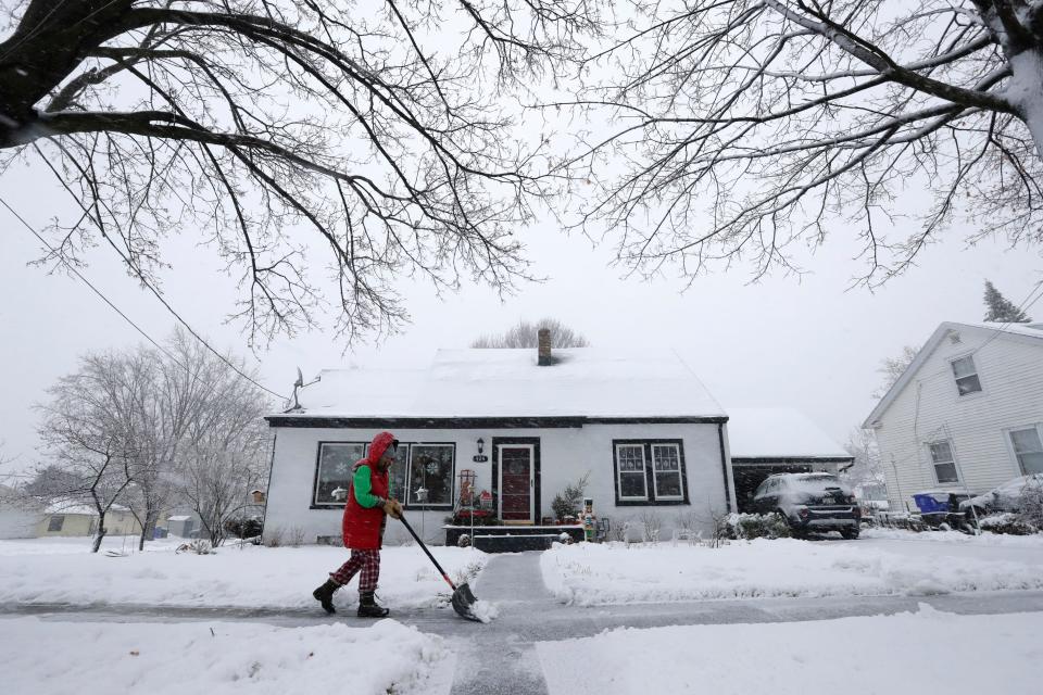
A massive winter storm dumped rain across the Northeast on Wednesday, flooding roads, closing schools and knocking out power the day after barreling through the south, leaving at least five dead in its wake.
The storm was on its way north into Canada later Wednesday after battering the region with wind gusts up to 95 mph, but more windy weather was expected through the evening. And more is yet to come later this week as another powerful storm will rev up by Friday, bringing more frigid air and snow to the East Coast, the National Weather Service said.
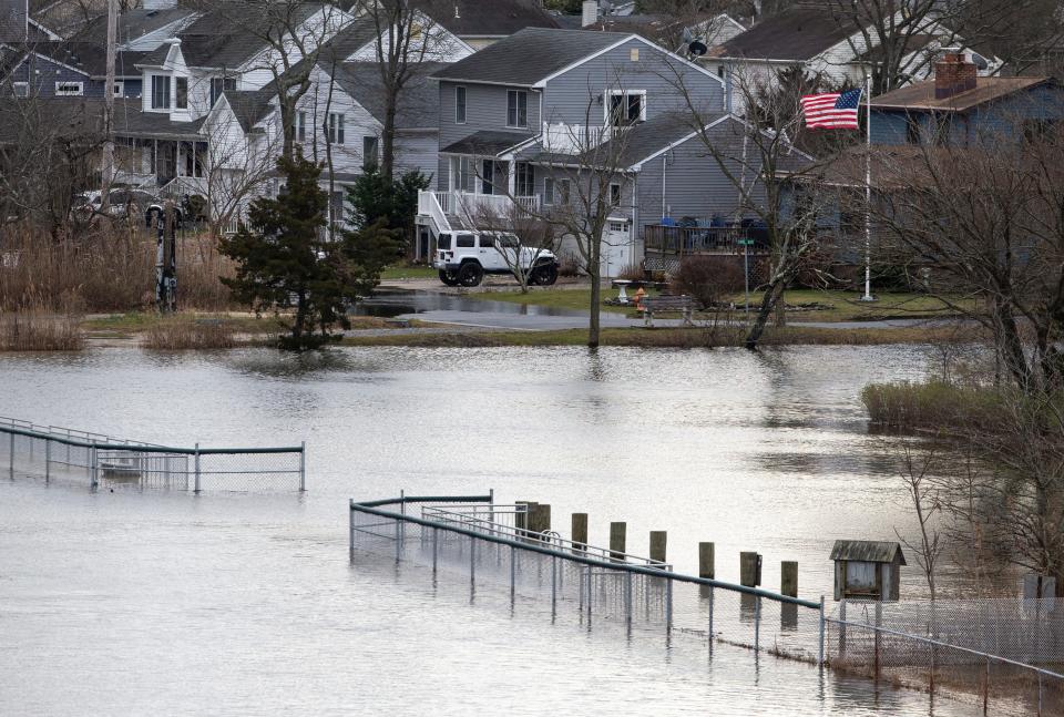
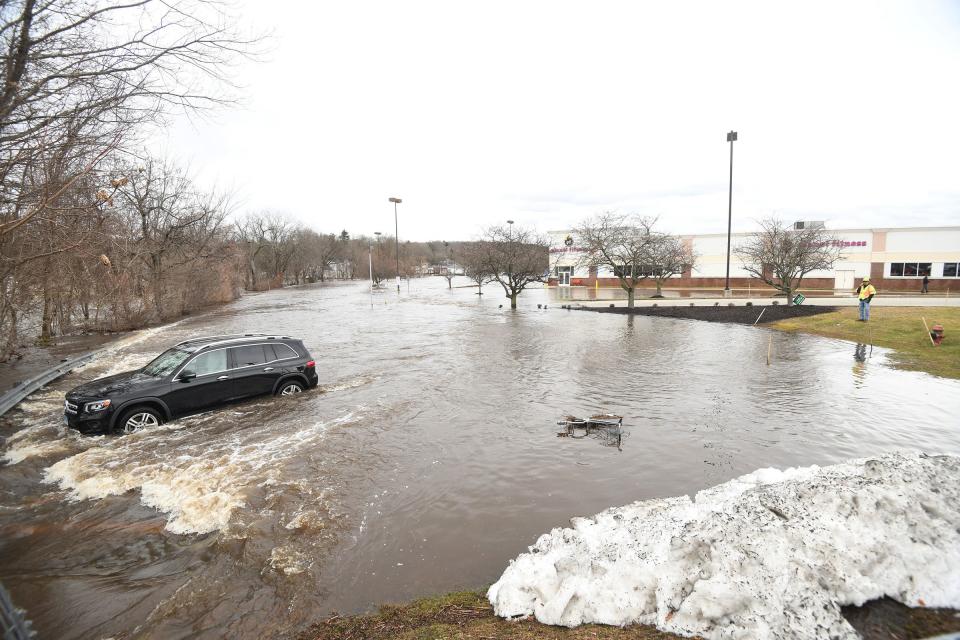
The combination of up to 3 inches of rain over highly saturated and snow-covered ground elevated the risk of flooding, especially along low-lying and coastal areas throughout the mid-Atlantic and New England, forecasters said.
Over 189,000 utility customers across New York State, New Jersey and Pennsylvania were without power Wednesday afternoon. Many school districts delayed the start of classes or canceled them because of the storm.
On Tuesday, the storm brought blizzard conditions, heavy rain and powerful winds to over 30 states and more than 2 million square miles. At least five deaths and several injuries were reported across the Midwest and Southeast. At least three tornadoes were confirmed across the Florida Panhandle on Tuesday with wind gusts as high as 106 mph.
Meanwhile, dangerous blizzard conditions that peaked on Tuesday persist in the Pacific Northwest, where heavy snow fall has made for treacherous travel conditions along mountain roads in the Cascades and Olympics.
The coldest air of the season will move into the central U.S. through the weekend as a cold front shifts south and high pressure builds to the north, according to the weather service. High temperatures in the Northern Rocky Mountains and Northern Plains are forecast to reach 10 to 20 degrees below zero on Friday and Saturday, and wind chills could exacerbate hypothermia and frostbite risks.
Developments:
∎ More than 15,000 flights were delayed across the nation Wednesday, and about 1,300 were canceled as the storm continued to move across the Northeast, according to FlightAware. Airports in Denver, Chicago and Miami accounted for the most travel delays and cancellations.
∎ Over 150 rivers throughout the Atlantic Coast were at their flood stage, according to the weather service.
∎ Amtrak canceled dozens of trains across the mid-Atlantic region and up through Maine on Wednesday, citing impacts of the immense winter storm that passed across the Northeast. Several of the canceled trains were in major metropolitan areas, including New York City, Boston and Philadelphia.
Get a grip on winter driving: How to prepare for snow and ice on the roads.
Evacuation order lifted after partial dam break in Connecticut
A mandatory evacuation order prompted by a partially damaged dam was lifted Wednesday after hundreds of people were forced to flee their homes, the Connecticut Division of Emergency Management and Homeland Security said.
Officials would be monitoring the dam through the night, the agency added.
The evacuation zone stretched for several miles along the Yantic River from the town of Bozrah to Uncas Falls in downtown Norwich, a city about 45 miles northeast of New Haven.
“The City Manager has determined that the Yantic River Flood Zone must be evacuated to protect the life and safety of residents in the area,” said a statement from Norwich Public Utilities.
An emergency shelter was opened at Kelly Middle School in Norwich, where the Red Cross was stationed to help the hundreds of people who had to leave their homes.
Around 7 a.m., Norwich Public Utilities announced the dam had partially collapsed. The company said Wednesday afternoon power was restored after cutting it off for about 5,000 customers to avoid “potentially catastrophic” infrastructure damage.
Norwich Public Utilities said the state Department of Energy and Environmental Protection would oversee stabilizing the damaged infrastructure, and a coffer dam would be installed to hold back water and “allow for further investigation and repair.”
At 12:15 p.m., the Yantic River was measured at 12.8 feet, according to the U.S. Geological Survey. The river’s flood stage is 9 feet.
Weather service confirms rare EF-3 tornado hit Florida
Four tornadoes, including a rare and powerful EF-3, slammed Florida on Tuesday, the National Weather Service confirmed after a preliminary damage survey Wednesday.
An EF-1 tornado slammed southwest Jackson County around 6 a.m. local time Tuesday, the weather service said, uprooting several trees and damaging some sheds in its seven-minute span. Minutes later, an EF-2 tornado in central Jackson County injured seven people, flipped over mobile homes and tore off roofs, according to a preliminary assessment.
The weather service also confirmed an EF-3 tornado and EF-2 tornado hit Bay County, both spawning from the same parent storm.
Don Van Dyke, a meteorologist at the weather service in Tallahassee, Florida, told USA TODAY the tornadoes were fueled by an unusually strong cold front, lots of wind shear and a moist and unstable airmass from the Gulf of Mexico. He noted EF-3 tornadoes were rare for the area, while lower-scale twisters were more common.
National Oceanic and Atmospheric Administration records show Florida only had 41 EF-3 tornadoes between 1954 and 2022.
Tornadoes are classified on the Enhanced Fujita scale, which ranges from zero to five. It takes into account estimated wind speeds, observed damage, and damage verified in weather service surveys after tornadoes.
An EF-3 tornado has wind gusts ranging from 136 to 165 mph. Its winds can destroy entire stories of well-constructed houses, severely damage large buildings such as shopping malls, overturn trains, rip off bark from trees, blow away structures with weak foundations, and lift heavy cars off the ground.
Storm kills at least 5 people, authorities say
Authorities said the large storm caused at least five deaths in Wisconsin, Alabama, Georgia and North Carolina on Tuesday.
One person was killed and four people were injured in Claremont, North Carolina, when a tornado hit Catawba County, damaging multiple homes in a mobile home park, county spokesperson Amy McCauley told USA TODAY. About 30 people were displaced by the storm, she said, and the American Red Cross was assisting with shelter efforts. The weather service preliminarily determined the storm was categorized as an EF-1 tornado, meaning it had 3-second wind gusts of 86 to 110 mph.
Police in Clayton County, south of Atlanta, say a man died during heavy rain when a tree fell on his car on a state highway in Jonesboro.
An 81-year-old woman died in Cottonwood, Alabama, after an apparent tornado touched down around 7:30 a.m. on Tuesday, Houston County Coroner Robert Byrd confirmed to USA TODAY. Charlotte Paschal's mobile home was picked up by the storm and "rolled" three to four times, Byrd said.
A second person in Alabama died Tuesday when a tree fell on the 68-year-old man’s car as he was driving down Crestwood Boulevard, Birmingham Fire and Rescue Battalion Chief Clay Hendon told USA TODAY. The storm had mostly passed by the time the man was on the road, but soaked grounds from earlier rainfall and high winds likely pushed the tree to collapse, Hendon said.
In Wisconsin, treacherous road conditions amid intense snowfall led to a car wreck in Jefferson County that left one person dead.
Rescue response: Avalanche at Palisades Tahoe ski resort forces closures in area as crews conduct search
Snowfall broke Des Moines record on Tuesday
Des Moines, Iowa, saw a record 8.3 inches of snow on Tuesday, breaking previous records for Jan. 9 snowfall, the National Weather Service said.
The previous record for Jan. 9 was 7.3 inches, set in 1957. Tuesday was the second day the storm dumped snow on Des Moines, which saw a total of 11.2 inches Monday and Tuesday.
Iowa may have its coldest Caucus Day ever on Jan. 15 with "arctic cold" en route to the state. By 6 p.m. on Monday, when people will be lining up to check-in before caucusing for Republican presidential primary candidates, temperatures are expected to be minus 1 to minus 5 degrees depending on which part of the state you're in. Wind chills in the evening could dip to nearly minus 20 degrees, meteorologist Brad Small said.
− The Des Moines Register
Maine flooding covers roads, submerges cars
Large swaths of Maine’s Atlantic Coast flooded early Wednesday as heavy rain poured across New England, melting snow banks and quickly raising the level of rivers and streams.
Stephen Oliver, a building contractor who lives and works in Hancock, a seaside town at the head of Frenchman Bay, said the storm surge had swelled over entire roadways and submerged cars.
“There's a lot of flooding everywhere,” he told USA TODAY.
Oliver, 47, spent Tuesday afternoon covering building materials in tarps and installing extra braces on a house he’s working on near the coast. Multiple building sites lost power overnight, he said.
Coastal communities may be inundated with up to 3 feet of water before the rain subsides, the weather service said. From Tuesday night to Wednesday morning, 1 to 4 inches of snow fell along Maine’s coastal towns and neighborhoods, while inland areas received snow totals in the double digits.
The York County emergency management department reported coastal flooding Wednesday morning, with water inundation of up to one foot in buildings in the village center of Kennebunkport and part of a road washed away in Biddeford, the weather service in Gray, Maine said.
Two previous storms also caused flooding and damaging winds in December, Oliver said. Weather this winter season has been “very unusual,” he said.
“This is like the third instance where there’s been heavy wind and rain in the last few months,” he said, adding that he can’t remember a time when extreme weather struck the region with a similar frequency.
Severe weather to continue: Bomb cyclone, arctic blast, East Coast snowstorm
The parade of snowstorms is just a teaser for what's to come. By Friday, cold air equivalent to true artic air will reach the central U.S., and many places will be unable to reach temperatures above zero degrees Fahrenheit by Sunday, according to AccuWeather Chief Meteorologist Jonathan Porter.
A possible "bomb cyclone" blizzard − a winter hurricane − could cause an arctic blast courtesy of the polar vortex in the Midwest next week as well as the first real East Coast snowstorm in years.
The National Weather Service said the storm carrying the arctic air will continue to bring heavy snow, blizzard conditions and snow squalls throughout parts of the Pacific Northwest through Thursday before the system makes its way to the Midwest later this week.
A polar vortex is just the beginning: January's weather forecast is chaotic and dangerous
Migrants in NYC sheltered at a school during storm
Nearly 2,000 migrants were brought to a high school in Brooklyn, New York, on Tuesday ahead of the storm's intense wind and rain.
The 500 families had been sheltering in tents at Floyd Bennett Field, an airfield in southeast Brooklyn, only a few miles from James Madison High School, when they were picked up in buses Tuesday evening and dropped off at the school.
The school's students studied from home Wednesday.
“This relocation is a proactive measure being taken out of an abundance of caution to ensure the safety and well-being of individuals working and living at the center,” the New York City Emergency Management said in a statement. “The relocation will continue until any weather conditions that may arise have stabilized and the facility is once again fit for re-occupancy.”
Zachary Iscol, the commissioner of the city’s emergency management department, said at a news conference the migrants were relocated primarily “because of the high winds.”
Around 5 a.m. Wednesday, when the storm had largely passed over the city and the strong winds had subsided, authorities began taking families back to the airfield.
Migrants arriving to NYC: City adds restrictions to 'rogue' buses of migrants sent by Texas gov.
Power outages surge across country
While heavy rain moved out of the area early Wednesday, more than 140,000 are without power in New York State after gusts of up to 60 mph knocked over power lines and downed trees.
More than 100,000 utility customers in Pennsylvania and 80,000 in North Carolina were without power at about 6 a.m., according to a USA TODAY tracker.
Areas throughout the Midwest, where snowfall has lessened since blizzard conditions swept over the region earlier this week, remained without power Wednesday morning. In Michigan, more than 44,000 utility customers had no power amid freezing temperatures.
By afternoon, things had improved somewhat. In New York, about 113,000 customers were still without power; 20,000 in North Carolina; and 28,000 in Michigan.
US weather watches and warnings
National weather radar
Contributing: Doyle Rice, Dinah Voyles Pulver, USA TODAY; The Associated Press
This article originally appeared on USA TODAY: Winter storm updates: Power outages, flooding across Northeast

