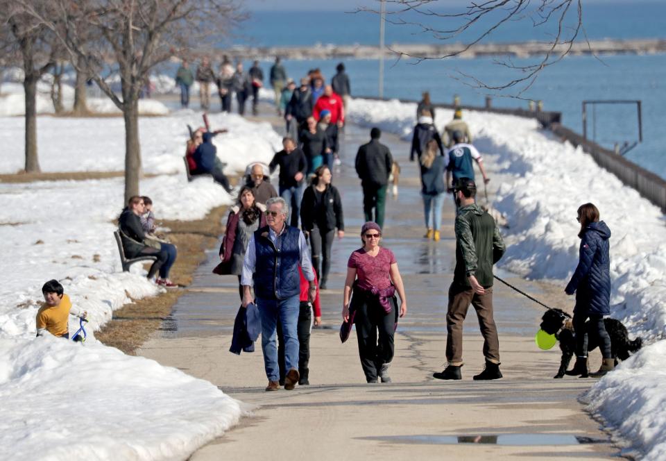
Milwaukee might see temperatures in the 60s before February is over, National Weather Service says
It's looking more and more likely that Milwaukee (and the rest of Wisconsin) will experience the warmest winter on record.
This February started out as Milwaukee's warmest on the books, setting three daily high temperature records of 49 degrees on Feb. 1, 59 on Feb. 8 and 54 on Feb. 9. High temps have been above average every day this month in Milwaukee, except last Friday and Saturday (which saw highs of 30 degrees), according to data from the State Climatology Office.
Normal temps for the end of February in Milwaukee are in the mid-30s. Most days this month have been eight-to-15 degrees above normal, said local National Weather Service meteorologist Jaclyn Anderson.
The forecast doesn't indicate that things are cooling down any time soon. The rest of the month is expected to see at or above-normal temperatures, with the possibility of at least one day in the 60s, Anderson said.
Currently, Milwaukee's warmest February on record occurred in 2017, when temperatures were 35.5 degrees on average. Accounting for the temps we've already seen this February and those in the forecast for the rest of the month, the average will be around 36.5 degrees, Anderson said, potentially setting the all-time record by one degree.
"Milwaukee is projected to see the warmest February on record based on where we're at now and the forecast going forward," she said. "It would have to be a pretty significant change, a pretty significant cooldown, for us not to at this point."
This winter, Wisconsin set the record for its warmest December on record at 10.9 degrees above normal, on average. And ― even with nine days of well-below-normal temperatures during a cold snap in the middle of the month ― this January was among the state's 10 all-time warmest at 8.5 degrees above normal, on average.
More: This will almost certainly be the warmest winter ever in Wisconsin's recorded history
Milwaukee weather forecast for the rest of February 2024
Milwaukee is expected to see temps at or above normal for the remainder of the month. Wednesday and Thursday could see highs as warm as the mid-50s, according to the National Weather Service.
The biggest fluctuation will occur Friday and Saturday, when a cold front is likely to knock high temperatures closer to normal for this time of year. AccuWeather forecasts that Milwaukee will see a high of 33 degrees Friday and 37 on Saturday before temps return to the low 50s on Sunday.
Next Tuesday could set another high temperature record for Milwaukee, Anderson said, "with temperatures climbing into the 60s." The city's current record high for Feb. 27 of 64 degrees was set in 2000, she added. Tuesday is also likely to see rain, and a slight chance of thunder is in the forecast.
With low temperatures expected to dip just below freezing but highs in the 40s, next Wednesday might see a rain-snow mix, Anderson said.
Why has this been the warmest winter in Wisconsin history?
The primary culprit behind Wisconsin's unseasonably warm winter is a weather phenomenon known as El Niño.
An El Niño event is caused when sea surface temperatures in the central and eastern Pacific Ocean warm to above average for several months. During an El Niño, the polar jet stream is shifted northward, which limits cold air intrusions from the north, NWS explains.
In general, El Niño brings above-average temperatures to the northern United States, which often result in below-average snowfall in moderate-to-strong El Niño years.
Last year, the Milwaukee area NWS said this winter's El Niño was on track to be one of the strongest on record.
According to the weather service, during the past seven winters with strong El Niño effects, temperatures across southern Wisconsin were "near average to 6 degrees above average." Additionally, snowfall has been as much as 18 inches below average in southern Wisconsin during strong El Niño winters.
It is important to remember that El Niño conditions ― warmer-than-average temps and below-average snowfall ― apply to the winter season average. Individual days can still see lots of snow, as Milwaukee saw in early January, or below-normal temperatures, as we saw in the middle of last month.
Could El Niño impact spring weather?
"It mostly just affects the wintertime, when our jet streams are the strongest across the country, because it impacts how far south the colder air from Canada can intrude into our neck of the woods," Anderson explained. "Once we head into the spring and summer months, those jet streams aren't necessarily as strong over the United States, so that correlation tends to weaken."
While the Climate Prediction Center expects El Niño to become more neutral in the summer months, it also says there are "increasing odds" of a La Niña effect developing next winter.
La Niña allows more Arctic air to make its way down to the Midwest, Anderson said, and can cause the opposite effects of El Niño ― meaning we could see a colder, snowier winter in 2025.
More: From sub-zero to 40s, what's caused temperatures to vary so much in Milwaukee this January?
More: Winter businesses may be eligible for disaster relief loans
This article originally appeared on Milwaukee Journal Sentinel: Milwaukee weather to remain warm for February 2024 with highs in 50s
